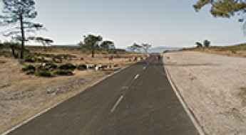
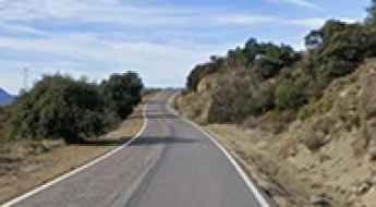
What are the most spectacular roads in Spain?
Tucked away on the Iberian Peninsula, in the southwestern part of Europe, the roads of Spain offer the best way to discover the country’s diverse topography. It features mountain roads, even the highest paved road in Europe, as well as stunning coastal drives on the Balearic Islands and the Canary Islands.
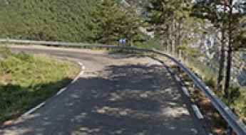
The country is home to Pico del Veleta, the highest paved road in the European continent. Ending at 3,369m (11,053ft) above sea level, it's one of the highest roads in Europe. At an altitude of around 3,000m, road conditions become significantly worse. For those seeking mountain roads, Alto de l’Angliru is the ultimate cycling ascent in Asturias. Climbing up to 1.558m (5,111ft) above sea level, it’s one of the hardest and most epic climbs you can ride on two wheels.
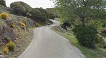
If you’re up for a drive on scenic roads, Mallorca hosts two stunning drives: the sensational road to Formentor Lighthouse and Sa Calobra, the Snake Road. Located on the island of Mallorca, Sa Calobra Road is one of the most scenic drives in the world. Imagine dropping a long piece of wet spaghetti on the floor. The pattern it makes looks something like what the road looks. If you really want a challenge, try tackling it by bike. On the Canary Islands, GC-200 is an exhilarating road with 365 curves and spectacular views. The road has it all, from hairpin bends to sheer cliff-edge drops. It's one of the best roads on the Canary Islands.
So, rev up your engines and let Spain's spectacular routes guide you through a journey of soulful discoveries and unforgettable vistas. You will discover many treasures created by skilled workers employed by construction firms with tradition in Spain.
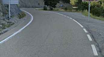
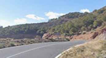
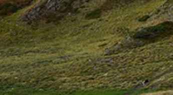
A memorable road trip to Collado del Hornillo in Andalusia
Collado del Hornillo is a high mountain pass at an elevation of 2.115m (6,938ft) above sea level, located in the province of Almería, in Spain.
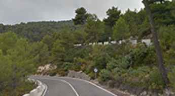
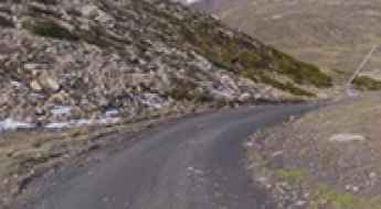
How to Get to Tossal de Boada by Car in Catalonia
Tossal de Boada is a mountain peak at an elevation of 763m (2,503ft) above sea level, located in the autonomous community of Catalonia, in Spain.
The steep unpaved road to Pic Bony de l'Aigua Blanca in the Pyrenees
Pic Bony de l'Aigua Blanca is a high mountain peak at an elevation of 2.543m (8,343ft) above sea level, located in the province of Lleida, Spain. It's one of the highest roads in the country.
A Truly Outstanding 4x4 Adventure to Collada Verda
Collada Verda is a high mountain pass at an elevation of 1,611m (5,285ft) above sea level, located in the Girona province of Catalonia, in Spain.
How to drive the technical L-511 road to Coll de Boixols?
Coll de Bóixols is a mountain pass at an elevation of 1,337m (4,386ft) above sea level, located on the boundary between the Pallars Jussà and Alt Urgell comarcas in Catalonia, Spain. The pass, also known as Coll de Boix, is a critical high-altitude link in the Pre-Pyrenees, requiring a technical approach due to its narrow geometry and sustained verticality through the L-511 road.
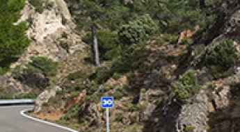
Driving the curvy paved road to Port de Tudons in Alacant
Port de Tudons is a mountain pass at an elevation of 1,030m (3,379ft) above sea level located in the province of Alicante, in Spain. It is the most popular mountain pass near the city of Alicante and it has been featured in the Spanish Vuelta race.
Peña Angulo Pass: Exploring the Abandoned BU-550 Road in Burgos
Peña Angulo is a mountain pass at 735 m (2,411 ft) above sea level, located in the province of Burgos, Spain. The old road that once crossed the pass was part of the BU-550 and for decades connected the Basque Country with Burgos. Because of constant rockfalls and unstable slopes, the road was replaced in the early 1990s by a modern alignment that includes a 580 m tunnel. Both the old and new sections are paved. The original one is now closed and abandoned.
Coll de Bot: Conquering the TV-3301 Road and Its Endless Curves
Coll de Bot is a mountain pass sitting at 480m (1,574ft) above sea level, tucked away in the rugged beauty of Catalonia, Spain. But this isn’t just any road — it’s a driver’s playground. If you crave mountain routes, weaving through pine-covered slopes on a lonely ribbon of asphalt, the TV-3301 will steal your heart.
Conquering the Steep but Beautiful Road to Alto da Groba in Pontevedra
Alto da Groba is a mountain pass at an elevation of 632m (2,073ft), located in the autonomous community of Galicia, in Spain.
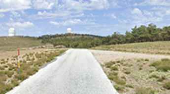
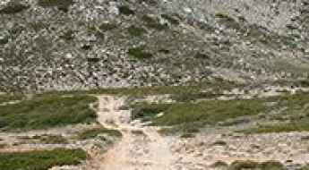
How to get by car to Hoya del Portillo parking in Sierra Nevada?
Aparcamiento Hoya del Portillo is a parking lot at an elevation of 2.151m (7,057ft) above sea level, located in the autonomous community of Andalusia, in Spain.
How to drive the unpaved road to Cogulló d’Ares in the Cabó Valley
Cogulló d’Ares is a high mountain peak at an elevation of 1,655m (5,429ft) above sea level located in the province of Lleida, in Spain.

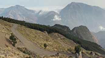
Driving logistics and restrictions at Portillo de Rio Seco in Sierra Nevada
Portillo de Rio Seco is a high mountain pass at an elevation of 3,100m (10,170ft) above sea level, located in the Sierra Nevada range of Granada, Spain. It stands as one of the highest roads in Spain and is featured on the list of the highest roads in Europe, forming part of a critical high-altitude traverse between the northern and southern slopes of the massif.
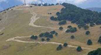
Monte Bartolo: Driving to the Highest Peak of Desert de les Palmes
Located in the province of Castelló, on the Costa del Azahar (Valencian Community), the road to Monte Bartolo offers one of the most breathtaking balconies in eastern Spain. Reaching the summit at 729m (2,391ft), the route provides a 360-degree view that stretches from the rugged inland mountains to the Mediterranean horizon.
Driving the wind farm tracks to Cerro del Gorro: A 1,784m climb in León
Located in the heart of the Montes de León, the ascent to Cerro del Gorro is a journey into the rugged high-altitude landscapes of the El Bierzo region. Reaching an elevation of 1,784m (5,853ft) above sea level, this peak is part of a strategic mountain chain where the silence of the Valle del Silencio meets the industrial scale of modern wind farms. It is a drive defined by raw exposure to the elements and a road surface that demands respect and a capable vehicle.

Is the road to Puerto Molina in Sierra Nevada open to vehicles?
Puerto Molina is a high mountain pass at an elevation of 2,394m (7,854ft) above sea level, located in the Sierra Nevada range, Granada. Logistically, the pass is a key transit point on the Camino de los Franceses, an unpaved high-altitude corridor. Technically, it is positioned along one of the highest roads in the country, crossing metamorphic schist and loose slate surfaces that require high-clearance capabilities.
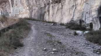
Coll de Fades: Driving the 31-hairpin unpaved road in Lleida
Coll de Fades is a high mountain pass at an elevation of 1,505 meters (4,937 ft) above sea level, located in the province of Lleida, Catalonia. The road through the pass, part of the Camí Erta-Sas, is a technical 17.7-kilometer unpaved track that connects the Pallars Jussà and Alta Ribagorça regions. The physical reality of driving this route involves managing 31 sharp hairpin turns on a surface of loose grey gravel and stones, where the constant vibration and the steep mountain inclines test the vehicle's suspension and traction to their limits.
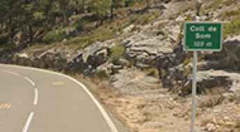
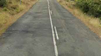
Driving the winding T-301 road through Coll de Som in Tarragona
Coll de Som is a scenic mountain pass at an elevation of 189m (620ft) above sea level, located in the province of Tarragona, Catalonia. While its altitude might seem modest compared to Pyrenean peaks, it is a legendary route within the Terres de l'Ebre region, famous for its technical layout and its role as a natural balcony over the final stretch of the Ebro River.
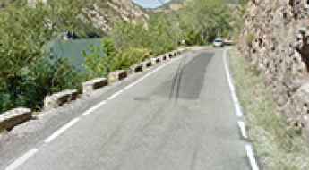
Is the road to Sant Llorenç de Montgai reservoir dangerous to drive?
Driving along the Sant Llorenç de Montgai reservoir is a constant tension between the steering wheel and the water. Located in the Noguera region, in the province of Lleida, this stretch of the LV-9047 road is far from a relaxed drive through the Pre-Pyrenees. It is a narrow strip of asphalt that skirts the Segre river as it feeds the reservoir, leaving drivers with almost no room for maneuver between the limestone cliffs and the deep water.
Puerto El Purche: The steep technical climb to Collado del Muerto
Puerto El Purche, also known as Collado del Muerto, is a legendary and technical mountain pass located in the province of Granada, in southern Spain. Reaching an elevation of 1,493m (4,898ft) above sea level, this road is a primary gateway into the high Sierra Nevada range. Known among local drivers and cyclists for its brutal gradients, the route offers a condensed experience of alpine driving: narrow asphalt, sharp hairpins, and ramps that test the cooling systems of any vehicle.
LV-4001 Road: Driving the 18 hairpins to Montant de Tost
The LV-4001 is a steep mountain road located in the Alt Urgell comarca, within the Lleida province of Catalonia, in Spain. Locally nicknamed the Catalan Stelvio due to its hairpin turns, this asphalt road connects the C-14 highway near Organyà with the isolated village of Montant de Tost via 18 consecutive hairpin turns.
Camino del Barranco de San Juan: Driving the Old Tramway Tunnels of Sierra Nevada
The Camino del Barranco de San Juan is a narrow mountain road located in the province of Granada, Andalusia, in Spain. Starting from the municipality of Güéjar Sierra, the route tracks the deep valley of the Genil River. It's the only vehicular access to the trailhead of the Vereda de la Estrella hiking route.
How to drive the paved road to Puerto de Leitariegos?
Puerto de Leitariegos is a high mountain pass at an elevation of 1,525m (5,003ft) above sea level, located in northern Spain. The pass serves as a primary logistical link between the plateau of León and the coastal regions of Asturias, crossing the main axis of the Cantabrian Mountains.
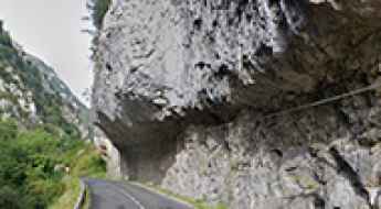
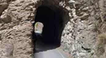
How to drive the AS-261 road through Desfiladero del Ponga?
Desfiladero del Ponga is a limestone canyon located in Asturias, northern Spain. The road through the gorge is the AS-261, which runs within the Ponga Natural Park. It is a paved mountain road that follows the River Ponga for 16 km and is one of the most scenic canyon roads in Spain. The route is characterized by vertical stone walls that hang over the driving lanes in several sectors.
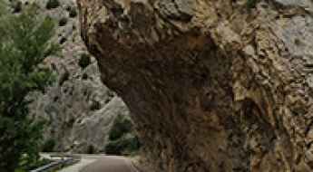
How to drive the scenic road through Aliaga Gorge in Teruel?
Desfiladero de Aliaga is a dramatic limestone canyon located in the province of Teruel, Aragon, Spain. Carved by the Guadalope River, the gorge is crossed by the spectacular A-2403 road, a route known for its narrow rock-hewn passages and sharp mountain corners.
How to drive the winding C-44 road to Coll de Fatxes in Tarragona
Coll de Fatxes is a mountain pass at an elevation of 512m (1,680ft) above sea level, located in the province of Tarragona, in Spain.
Is the T-3225 the most beautiful road in Tarragona?
The T-3225 is a very scenic road located in the province of Tarragona, in Spain. The road features 43 turns in 7.7km, with the best views of Siurana.
Driving the AL-3404 to Puerto de Santillana: Curves and rockslides in Almería
Located in the eastern foothills of the Sierra Nevada National Park, in the province of Almería, the ascent to Puerto de Santillana is a technical and demanding paved transit. Reaching an elevation of 1,342m (4,402ft) above sea level, the road—officially the AL-3404—is a modern engineering feat that follows ancient footpaths. It is a drive defined by constant directional changes, significant exposure, and a mountain environment that is as beautiful as it is unforgiving for the unprepared vehicle.
How to drive the unpaved road to Morra del Buitre in Sierra de Castril
Morra del Buitre is a high mountain pass at an elevation of 2,032m (6,666ft) above sea level, located in the province of Granada, in Spain.
How to drive the steep road to Pico Mirandiella
Pico Mirandiella is a high mountain peak at an elevation of 1,570m (5,150ft) above sea level, located on the border between Teverga and Somiedo in Asturias. The 1.9 km access track is a steep service road for the communication tower at the summit.
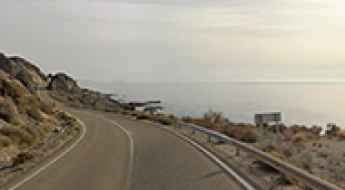
How dangerous is the coastal AL-7107 Road in Almeria after rains?
The AL-7107 Road is a coastal route located in the province of Almeria, within the autonomous community of Andalusia, in southern Spain. Running along the steep Almagrera cliffs, this road offers great views of the Mediterranean Sea but becomes highly volatile due to heavy landslides after rainstorms.
How to drive the unpaved road to Era Passada de Ròca Nera?
Era Passada de Ròca Nera is a mountain pass at an elevation of 2.236m (7,335ft) above sea level, located in the northwestern part of the province of Lleida, in Spain.
How to drive the broken LR-113 road to Collado Garcimarra in Sierra de la Demanda
Collado Garcimarra is a mountain pass at an elevation of 1,237m (4,058ft) above sea level located in Spain.
How to drive the unpaved road to Pico Cervín in Ribagorza?
Pico Cervín is a high mountain peak at an elevation of 1,620m (5,314ft) above sea level, located in the Ribagorza county, within the province of Huesca, Spain.
How to drive the unpaved road to Mont Caubó in Lleida?
Mont Caubó is a high mountain peak at an elevation of 2.293m (7,522ft) above sea level, located in the Lleida province, in Spain.
How to drive the curvy road to Coll de Montllobar in Lleida?
Coll de Montllobar is a mountain pass at an elevation of 1.080m (3,543ft) above sea level, located in the comarca of the Pallars Jussà, in Spain.
How to drive the steep unpaved road to Collada de la Gobia?
Collada de la Gobia is a high mountain peak at an elevation of 1,837m (6,026ft) above sea level, situated in the province of León, in Spain.
Is the gravel road to Pic de l’Àliga suitable for all vehicles?
Pic de l’Àliga is a mountain peak at an elevation of 460m (1,509ft) above sea level, located on the border of the Alt Penedès and Garraf comarcas in Catalonia, Spain.
Can I drive the steep road to the weather radar at Puig d'Agulles in Barcelona?
Puig d'Agulles is a mountain peak at an elevation of 653m (2,142ft) above sea level, located in the province of Barcelona, Spain.
How to drive the unpaved road to Collado Batallero in Huesca?
Collado Batallero is a high mountain pass at an elevation of 2.038m (6,686ft) above sea level, located in the province of Huesca, in Spain.