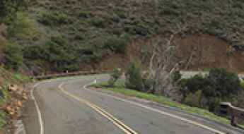
What are the most spectacular roads in the USA?
Located in North America, the USA is a true paradise for drivers, as it hosts more than 2,000 roads listed as the most spectacular in the world.
Featuring mountains, deserts, coasts, and snow, in the USA you’ll get your dream road. And you’ll never want to wake up. For instance, at the top of your list, you need to drive the Million Dollar Highway, the most beautiful road in America, and probably in the world. Built in the late 1880s, you'll be on the "outside" for a while with a hell of a view to your right (let the passenger enjoy the view; you'll want to watch the road). Another paved option must be the Iron Mountain Road, featuring 17 miles, 314 curves, 14 switchbacks, 3 pigtails, and 3 tunnels in the Black Hills of South Dakota. No list would be complete without the winding Tail of the Dragon: 318 curves in 11 miles. Spanning Tennessee and North Carolina, it is one of the most scenic drives in the USA. You also can’t skip driving Mount Evans Scenic Byway, the highest paved road in North America, climbing up to 4,310m (14,130ft) in Colorado. It is said to be the highest paved road in North America.
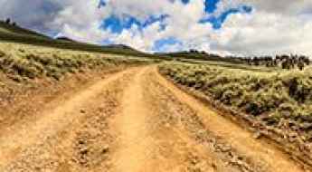
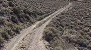
For those who prefer unpaved experiences, the country hosts some of the most defiant yet scenic roads in the world. You can’t miss Black Bear Pass, a high mountain adventure in the Colorado Rockies. Climbing up to 3,915m (12,844ft) above sea level, it's one of the highest roads in Colorado. You can also discover the beauty of Engineer Pass, a mountain pass at an elevation of 3,901m (12,800ft) above sea level in Colorado. It’s mostly a first-gear ride because the road is rough and rocky. The legendary Shafer Trail Road in Utah's Canyonlands National Park is an iconic drive located on the east-central edge of Utah. At times, the road is so narrow that only one car can pass. And Lippincott Mine Road in California is for experienced 4WD drivers using high-clearance vehicles only. You'll need a good map, as the routes are not marked and there are no signs. It’s one of the challenging backcountry roads in Death Valley National Park.
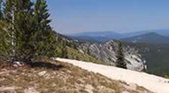
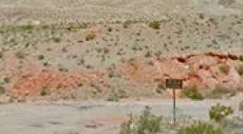
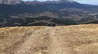
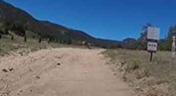
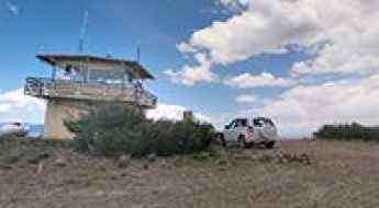
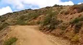
How to get by car to the lookout at Square Mountain in Idaho?
Square Mountain is a high mountain peak at an elevation of 2,435m (7,988ft) above sea level, located in Idaho County, in the U.S. state of Idaho.
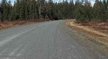
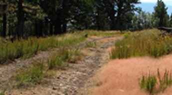
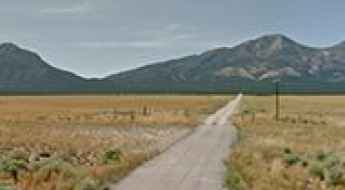
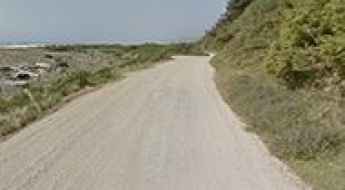
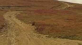
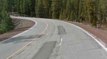
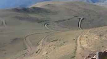
Adventure Along Forest Highway 10 in Alaska
Forest Highway 10 is a very scenic drive located in the U.S. state of Alaska, between the town of Yakutat and Harlequin Lake.
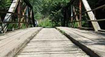
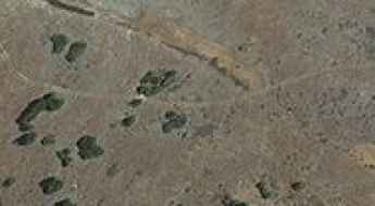
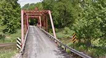
How to drive the wooden Lake Catatoga Road Bridge in Illinois?
The Lake Catatoga Road Bridge is a specialized wooden structure located in Macoupin County, Illinois, USA. Situated within the private residential area of Lake Catatoga, this 22-meter bridge serves as a critical logistical link for local transit. Despite its short length, it is considered one of the most spectacular bridges in the world due to its primitive construction and strict weight constraints.
Casner Mountain Trail in Arizona: The Road That Has It All!
Straddling Yavapai and Coconino counties, in the U.S. state of Arizona, Casner Mountain Trail No. 8 is one of the most scenic and rugged trails in Arizona. It’s designated as a motorized trail with very rugged conditions along a narrow ridge with limited opportunities for two-way traffic.
The Ultimate Guide to Traveling the Anniversary Mine Road in Nevada
Anniversary Mine Road is a very scenic drive located in Clark County, in the U.S. state of Nevada. It requires a carefully driven high-clearance vehicle, although 4WD would be safer.
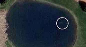
How Google Maps Uncovered a 9-Year-Old Mystery
The intersection of digital cartography and forensic investigation reached a turning point with the case of Davie Lee Niles. Missing since October 11, 2006, after leaving a local establishment in Byron Township, Michigan, Niles’ disappearance remained an unsolved cold case for nearly a decade. Ironically, the key evidence—a submerged vehicle—had been publicly accessible via satellite imagery for years before being identified by the human eye.
Driving the Saratoga Spring Road in Death Valley NP
Saratoga Spring Road is a thrilling desert drive located in San Bernardino County, in the U.S. state of California. It is one of the challenging backcountry roads in Death Valley National Park.
How to get by car to Dipper Lake in Wyoming?
Dipper Lake is a high mountain lake at an elevation of 3,279m (10,757ft) above sea level, located in Carbon County, in the U.S. state of Wyoming. It’s one of the highest roads in Wyoming.
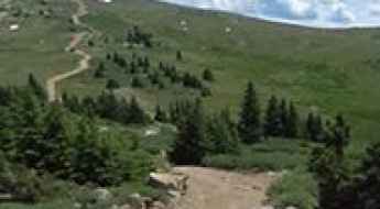
The Wild Road to Bald Mountain in Summit County
Bald Mountain is a high mountain peak at an elevation of 3,955m (12,975ft) above sea level, located in Summit County, in the U.S. state of Colorado. It’s one of the highest roads in Colorado.
How to get by car to Mangas Mountain in New Mexico?
Mangas Mountain is a high mountain peak at an elevation of 2,948m (9,671ft) above sea level, located in Catron County, in the US state of New Mexico.
How to get to the summit of Tucumcari Mountain in New Mexico?
Tucumcari Mountain is a high mountain peak at an elevation of 1,514m (4,967ft) above sea level, located in Quay County, in the US state of New Mexico.
Road Trip Guide: Conquering Iron Mountain in Montana
Iron Mountain is a high mountain peak at an elevation of 3.082m (10,111ft) above sea level, located in Sweet Grass County, in the U.S. state of Montana. It’s one of the highest roads in Montana.
Road trip guide: Conquering La Salle Pass in Colorado
La Salle Pass is a high mountain pass at an elevation of 2,973m (9,753ft) above sea level, located in Park County, in the U.S. state of Colorado.

Travel Guide to the Top of Mount Waas in Utah
Mount Waas is a high mountain peak located in Grand County, in the U.S. state of Utah. Set high in the Northern La Sal Mountains, the summit is accessed by either Beaver Basin or Miner’s Basin.

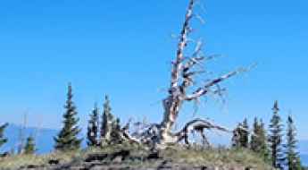
A memorable road trip to Tyee Mountain in Washington
Tyee Mountain is a high mountain peak at an elevation of 2,029m (6,656ft) above sea level, located in Chelan County, in the U.S. state of Washington. The peak is most notable for the fire lookout atop its summit. It’s one of the highest roads in Washington.
The road to Gold Hill in Colorado is not for the inexperienced
Gold Hill is a high mountain pass at an elevation of 3,752m (12,309ft) above sea level, located in the U.S. state of Colorado. It’s one of the highest roads in Colorado. The extremely fun and scenic trail through the summit connects Taylor Park to the south and Ashcroft/Aspen to the north.
Road trip guide: Conquering County Highway 730 in Colorado
County Highway 730 is a high mountain road located in Grand County, in the U.S. state of Colorado. It’s one of the highest roads in Colorado.
A Memorable Road Trip to Mount Dutton in Utah
Mount Dutton is a high mountain peak at an elevation of 3,371m (11,059ft) above sea level, located in Garfield County, in the U.S. state of Utah. It’s one of the highest roads in Utah.
A Memorable Road Trip to Patterson Pass in Nevada
Patterson Pass is a high mountain pass at an elevation of 2,260m (7,414ft) above sea level, located in Lincoln County, in the U.S. state of Nevada.
Travel guide to the top of Mount Withington in New Mexico
Mount Withington is a high mountain peak at an elevation of 3,087m (10,127ft) above sea level, located in Socorro County, in the U.S. state of New Mexico. It’s one of the highest roads in New Mexico.
A memorable road trip to Mount Champion in Colorado
Mount Champion is a high mountain peak at an elevation of 3,930m (12,893ft) above sea level, located in Lake County, in the U.S. state of Colorado. It’s one of the highest roads in Colorado.
The road to Pomeroy Lake in Colorado is not for timid drivers
Pomeroy Lake is a high mountain lake at an elevation of 3,672m (12,047ft) above sea level, located in Chaffee County, in the U.S. state of Colorado. It’s one of the highest roads in Colorado.
How to get by car to the stunning Gold Bluffs Beach in California?
Gold Bluffs Beach is a remote beach, renowned for its golden sands, rugged bluffs, and proximity to old-growth redwood forests, located in Humboldt County, in the U.S. state of California. It’s one of the most scenic drives in the Redwood National and State Parks.
The road to Sheep Mountain in California isn’t an easy one
Sheep Mountain is a high mountain pass at an elevation of 3.626m (11,896ft) above sea level, located in Mono County, in the U.S. state of California. It's one of the highest roads in California.
Roadkill hotspots in the USA
With a road network exceeding 4 million miles, the United States presents a constant intersection between high-speed transit and wildlife corridors. It is estimated that over one million animals die daily in vehicle collisions, a statistic that represents not only a biological crisis but a significant safety hazard for motorists. Annually, approximately 2 million wildlife-related accidents result in insurance claims and over 200 human fatalities, making animal strikes a primary concern for rural and mountain driving.
The Ultimate Guide to Traveling to Thousand Lake Mountain in Utah
Thousand Lake Mountain is a high mountain plateau at an elevation of 3,417m (11,210ft) above sea level, located in Wayne County, in the US state of Utah. It’s one of the highest roads in Utah.
Latigo Canyon Road is an awe-inspiring drive in Malibu
Latigo Canyon Road is a very technical drive located in Los Angeles County, in the U.S. state of California. The road is a test for any kind of rider. It’s one of the Top Scenic Drives in Malibu.
How to Travel the Phinney Canyon Road in Nevada
Phinney Canyon Road is an exciting desert drive located in Nye County, in the U.S. state of Nevada. A high-clearance vehicle is required for the first 21 miles, and 4x4 is necessary beyond that. It’s one of the challenging backcountry roads in Death Valley National Park.
The Road to Upper Pomeroy Lake in Colorado is Not for the Faint of Heart
Upper Pomeroy Lake is a high mountain lake at an elevation of 3,744m (12,283ft) above sea level, located in Chaffee County, in the U.S. state of Colorado. It’s one of the highest roads in Colorado.
The Wild Road to Tesuque Peak in New Mexico
Tesuque Peak is a high mountain peak at an elevation of 3,678m (12,066ft) above sea level, located in Santa Fe County, in the U.S. state of New Mexico. It’s one of the highest roads in New Mexico. The road to the summit is currently closed to private vehicles, blocked with a barrier.
How to Get to Buffalo Boy Mine by Car in Colorado?
Buffalo Boy Mine was a small gold and silver mine located in San Juan County, in the U.S. state of Colorado, at an elevation of 3,984m (13,070ft) above sea level. It is one of the highest roads in Colorado.

The breathtaking road to Rocky Bottom Lake in California
Rocky Bottom Lake is a high mountain lake at an elevation of 3,280m (10,761ft) above sea level, located in Inyo County, in the U.S. state of California. It’s one of the highest roads in California.
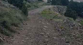
Driving the Scenic Montana Mountain Trail in Gila County
Montana Mountain Trail is a very scenic and challenging loop drive located in Gila County, in the U.S. state of Arizona. It’s a narrow trail up the mountain, with multiple river crossings.
Crossing the iconic Bertram Bridge in Iowa
Located in the village of Bertram in southern Linn County, in the US state of Iowa, Bertram Bridge is a bridge across the Big Creek river. It’s one of the most spectacular bridges in the world.
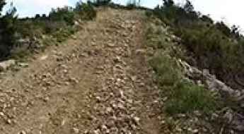
A Wild, Tough Mining Road to Wise Mountain in Colorado
Wise Mountain is a high mountain peak at an elevation of 3,675m (12,057ft) above sea level, located in eastern Summit County, in the U.S. state of Colorado. The road to the summit is dangerously steep with big, loose rocks. It’s one of the highest roads in Colorado.
Adventure Along Saddle Mountain Road in Arizona
Saddle Mountain Road is a very scenic drive running around the uniquely formed volcanic Saddle Mountain in Maricopa County, in the U.S. state of Arizona.
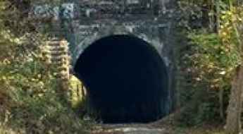
How to Get to the Haunted Moonville Tunnel in Ohio by Car?
Moonville Tunnel is located deep in the backwoods of Vinton County, in the U.S. state of Ohio. The ghost of a drunken man who was murdered near the tunnel is said to walk above it and toss pebbles at those below.
A memorable road trip to Spring Creek Pass in Colorado
Spring Creek Pass is a high mountain pass at an elevation of 3,323 meters (10,901 feet) above sea level, located in Hinsdale County, in the U.S. state of Colorado.
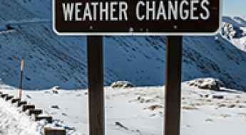
What to Know Before Driving High Mountain Roads in the USA?
Driving high mountain roads in the USA—from the 12,000-foot passes of the Colorado Rockies to the ridges of the Sierra Nevada—introduces severe mechanical, meteorological, and physiological variables. High-altitude environments feature rapid atmospheric changes that impact both vehicle performance and driver behavior.
The Ultimate Guide to Traveling to Agua Fria Peak in New Mexico
Agua Fria Peak is a high mountain peak at an elevation of 3,380m (11,089ft) above sea level, located in southwestern Colfax County, in the U.S. state of New Mexico. It’s one of the highest roads in New Mexico.
The road to Fredonyer Pass in California is well worth the time
Fredonyer Pass is a high mountain pass at an elevation of 1.762m (5,780ft) above sea level, located in Lassen County, in the US state of California.
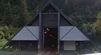
Anton Anderson Memorial Tunnel: Where Trains and Cars Share a Narrow, 2.5-Mile Tunnel
Anton Anderson Memorial Tunnel is located in the U.S. state of Alaska. It passes under Maynard Mountain and carries the scenic Portage Glacier Road. Also known as the Whittier Tunnel, it is the longest combined vehicle-railroad tunnel in North America. The tunnel is a single-lane, multi-use tunnel shared by cars and trains traveling in both directions.
A memorable road trip to Banner Creek Summit in Idaho
Banner Creek Summit is a high mountain pass at an elevation of 2,153 meters (7,063 feet) above sea level, located in the U.S. state of Idaho.
How To Travel The County Road 36 in Colorado?
County Road 36 is a high mountain road located in Hinsdale County, in the U.S. state of Colorado. It’s one of the highest roads in Colorado, topping out at 3.772m (12,375ft) above sea level.
A Memorable Road Trip to Mount Grant in Nevada
Mount Grant is a high mountain peak at an elevation of 3,388m (11,115ft) above sea level, located in Mineral County, in the U.S. state of Nevada. The road to the summit has steep cliffs along the shoulder, so drive cautiously. It's one of the highest roads in Nevada.
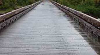
How to drive the wooden bridge over Harlequin Lake in Alaska?
The Harlequin Lake Bridge is a timber structure located within the Tongass National Forest in the U.S. state of Alaska. Part of the Forest Highway 10, this bridge is a critical logistical point on the route from Yakutat to the Dangerous River.
A Memorable Road Trip to Black Sage Pass in Colorado
Black Sage Pass is a high mountain pass at an elevation of 2,976m (9,763ft) above sea level, located in Gunnison County, in the U.S. state of Colorado.
A scenic paved road to Kings Hill Pass in Montana
Kings Hill Pass is a high mountain pass at an elevation of 2,251 meters (7,385 feet) above sea level, located in the US state of Montana.