What are the most spectacular roads in China?
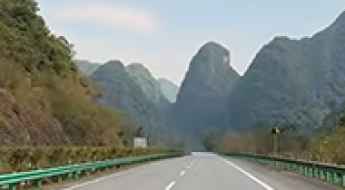
Located in the eastern part of Asia, and bordering 14 countries, China covers 9.6 million square kilometers. It’s the world's third-largest country by land area and it hosts more than 500 brutal driving experiences, listed as the most spectacular roads in the world. Due to its size and difficult geography, featuring mountains, plateaus, deserts, and plains, it has scenic, mountainous, and even flooding roads. It also holds many records, such as the world's longest traffic jam: a 100 km, 12-day standstill that occurred in August 2010, when the country witnessed the mother of all traffic jams.
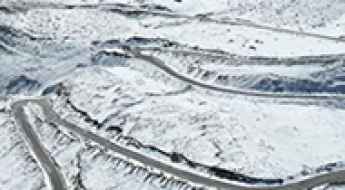
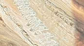
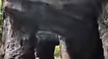
When travelling to China, you can’t miss the infamous Tian Men Shan Big Gate, a road with 99 turns, built in 1998, that offers a thrilling 11-kilometer journey; or the iconic Guoliang Tunnel, which was dug through the side of a mountain by hand. Built in the early 1970s it is one of the most famous Chinese tunnel roads. It’s also worth driving the Sichuan-Tibet Highway, one of the world's highest roads.
And if you like challenging mountain roads situated at high elevations, remember to check out our list with the highest roads in China, where you’ll find real gems, such as Chāmkang, a mountain pass at 5.953m (19,530ft) above sea level.
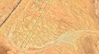
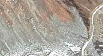
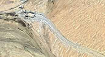
Aryktoryk Pass: Driving the High-Altitude Border Road in Xinjiang
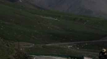
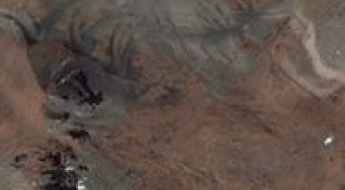
Aryktoryk Pass is a high mountain pass at an elevation of 3,468 meters (11,377 feet) above sea level, located in Wuqia County, in Xinjiang, China.
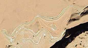
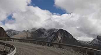
Driving the Remote Unpaved Road to Nyadong La in Tibet
Nyadong La is a high mountain pass situated at an elevation of 5,224m (17,139ft) above sea level in the southeastern Tibet Autonomous Region of China. Located in the heart of the Himalayas, this remote pass offers some of the most dramatic and least-visited landscapes in the Xigazê Prefecture.
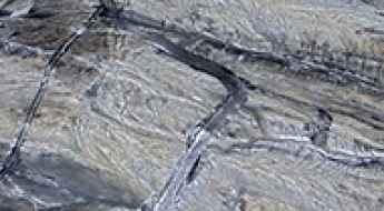
The Road to Nampa La in Tibet Is Not an Easy One
Nampa La is a high mountain pass at an elevation of 5,460m (17,913ft) above sea level, located on the border of Doilungdêqên District and Qüxü County, Lhasa Prefecture, Tibet.
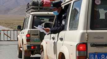
Driving your own vehicle in China: Logistics and border requirements
Entering the People's Republic of China with a foreign-registered vehicle is one of the most complex logistical operations in the world of overlanding. Unlike most international borders, China does not recognize the International Driving Permit (IDP) and strictly prohibits independent driving for foreigners. Crossing into Chinese territory requires a minimum of three to six months of prior coordination with government-authorized agencies, a mandatory escort, and a full mechanical and bureaucratic validation of both the driver and the vehicle.
A Wild Paved Road to Dzamba La
Dzamba La is a high mountain pass at an elevation of 4,901m (16,079ft) above sea level, located in Batang County, Sichuan Province, China.
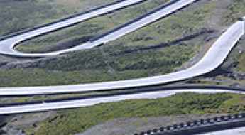
Driving the S60 Hena Expressway through the Guangxi Karst peaks
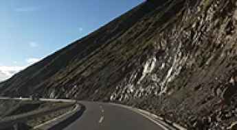
The Hena Expressway (S60) is a major high-speed logistical corridor at an elevation of varying karst plateaus, located in the Guangxi Zhuang Autonomous Region of southern China. Spanning 516 kilometers (320 miles), the S60 connects Hepu County to Napo County, traversing some of the most complex limestone topographies in Asia.

Top Three Best Cities in China for International Students and Young Travelers
Over the years, the number of international students and travelers coming to China has increased. China offers many advantages to international students, opening up numerous opportunities during their studies. China is a vast country with a rich history and diverse culture. It has a wide variety of ethnicities, landmarks, languages, and historical figures.
How to drive the unpaved Tiantao Line in the Taihang Mountains?
Tiantao Line, also known as the Taihang Bingchacha, is a mountain cliff road located in the Taihang Mountains, on the boundary between Pingshun County (Shanxi Province) and Linzhou (Henan Province), in China. The track is cut into the limestone walls of the range.
Muling La: The grueling 5,556m unpaved pass in Western Tibet
Muling La is a high-mountain pass at an elevation of 5,556m (18,228ft) above sea level, located in Zanda County, Ngari Prefecture, Tibet Autonomous Region, China. The track cuts through the western Transhimalaya range near the regional border lines.
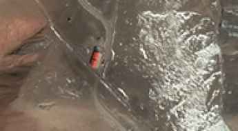
Is the military road to Uzbel Pass on the China-Tajikistan border paved?
Forget about your GPS or your travel plans; the Uzbel Pass is a place you will likely never see in person. Sitting at 4,685m (15,370ft) in the heart of the Pamir Mountains, this pass isn't a mountain crossing for travelers—it's a hardcore military zone on the sensitive border between China (Xinjiang) and Tajikistan. If you try to drive here, you won't find a road; you'll find a checkpoint with soldiers who won't be happy to see you.
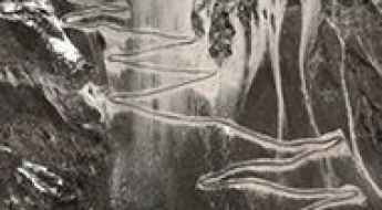
How to drive the 26 hairpins of the Kuteruk Pass?
Kuteruk Pass (also transcribed as Kuteerke) is a mountain pass at an elevation of 3,365m (11,040ft) above sea level, located in the Kunlun Mountains of Kargilik County, Xinjiang, China. The route runs through the Kashgar Prefecture, connecting the western settlement of Xikebande with Suluge Azi to the east.
Driving to Qiewulida Yiding Biele Pass: A remote journey through the Pamir Mountains
Qiewulida Yiding Biele Pass is a high-altitude mountain pass reaching an elevation of 4,463m (14,642ft) above sea level, located in Akto County, within the Kizilsu Kyrgyz Autonomous Prefecture of Xinjiang, China. This remote pass sits in the heart of the Pamir Mountains, a desolate and high-altitude wilderness.
Road to Oibalegen Pass: Driving the 4,624m Border Track in Xinjiang
Located in Akto County, within the Kizilsu Kyrgyz Autonomous Prefecture of Xinjiang, China, Oibalegen Pass is a high-altitude mountain pass reaching an elevation of 4,624m (15,170ft) above sea level. Situated near the Gorno-Badakhshan Autonomous Province of Tajikistan, the route is a critical unpaved road connecting the remote settlement of Chongrang with the international border.
How to drive the Meihan Road through Dawaliangzi Pass?
Dawaliangzi Pass, also known as Dawaliang, is a high-altitude mountain pass at an elevation of 4,597m (15,082ft) above sea level in Xiaojin County, Sichuan Province. The pass is a critical point on the Meihan Road (Meiwo-Hanniu), an 84 km highway that traverses the Mukekeliangzi range at peaks reaching 4,916m. This route was a key post-disaster reconstruction project following the 2008 Wenchuan earthquake, providing a direct tactical link between Meiwo and Hanniu townships that bypasses a previous 110 km detour through Danba County.
Road to Kuribankasi Daban: Driving the 4,267m Military Track in Xinjiang
Located in Akto County, within the Kizilsu Kyrgyz Autonomous Prefecture of Xinjiang, in China, Kuribankasi Daban (also known as Aghbai Budabel) is a high-mountain pass at an elevation of 4,267m (13,999ft) above sea level.
How to Drive the 42 Hairpin Turns of Kulamba Pass?
The Kulamba Pass is a high-altitude mountain crossing located in Kargilik County (Yecheng), within the Kashgar Prefecture of the Xinjiang Uyghur Autonomous Region. Reaching an elevation of 4,009m (13,152ft) above sea level, this unpaved track represents an extreme logistical challenge due to its vertical gain and the precarious nature of its switchbacks. Navigating this pass requires a specialized 4x4 vehicle and advanced mountain driving skills to manage the sustained torque demands and the lack of structural safety barriers.
How to drive the high-mountain road from Chuzhig to Nyangra?
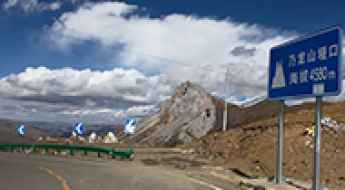
The road from Chuzhig to Nyangra is a high-altitude paved trip located in Xaitongmoin County, within the Xigazê prefecture of the Tibet Autonomous Region, China. Spanning 44.4 km, this mountain route is a vital link situated to the east of the Lungzang La pass. The road is engineered to traverse extreme terrain, reaching a peak elevation of 5,400m (17,716ft) above sea level.
How to drive the unpaved and remote S224 road to Riadong La in the Qiajajima Mountains?
Riadong La is a high mountain pass at an elevation of 5,005m (16,420ft) above sea level, located on the border of Zadoi and Zhidoi counties in the Yushu Prefecture of Qinghai, China.
How to drive the 26 hairpin turns to Nailong Pass in Sichuan
Nailong Pass is a high mountain pass at an elevation of 4,549m (14,924ft) above sea level, located in Garzê County, Sichuan Province, China. Traversed by the paved S455 highway, the pass is known for its extreme altitude and a relentless wall of 26 tight hairpin turns near the summit ridge.
How to drive the Old G214 to Baima Snow Mountain Pass in Yunnan?
Baima Snow Mountain Pass, also known as Baimang Shan Yakou, is a high mountain pass at an elevation of 4,363 meters (14,314 ft) above sea level in Deqen County, Yunnan.
How to drive the paved Baojin Line to Xuechao Pass
Xuechao Pass is a high mountain pass at an elevation of 3,707m (12,162ft) above sea level, located in China.
How to drive the unpaved and steep road to Dzi La?
Dzi La is a high mountain pass at an elevation of 4,799m (15,744ft) above sea level in Sêrxü County, within the Garzê Tibetan Autonomous Prefecture of Sichuan, China.
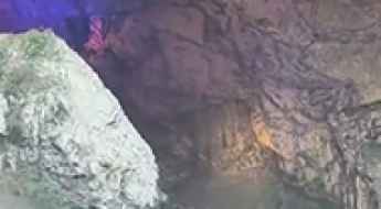
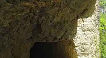
How to drive through the 861 Tunnel in Hunan?
The 861 Tunnel, also known as Baliuyi Tunnel, is a unique natural cave road located in Xiaopingzhen, within Chenxi County of China's Hunan province. It is one of the few places where you can drive through a cave on a fully paved surface.
What are the driving conditions on the road to Bairi Pass?
Bairi Pass is a high mountain pass at an elevation of 4,556m (14,947ft) above sea level, located in Dawu County, within the Garzê Tibetan Autonomous Prefecture of Sichuan. The route is a critical link between the high Tibetan Plateau and the lower valley settlements. Driving this section of County Road 179 requires managing a massive vertical drop that puts extreme stress on any vehicle's braking system.
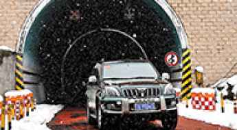
Get behind the wheels for Dulongjiang Tunnel, the lifeline of the Gaoligong Mountains
The Dulongjiang Tunnel is a high-altitude road tunnel located in Gongshan County, within the Yunnan province of China. Cutting through the Gaoligong Mountain range at over 3,000 meters, this 6,680-meter tunnel provides the only year-round link to the remote Dulongjiang Valley.
How to drive the old paved road to Dariga Pass?
Dariga Pass is a high mountain pass at an elevation of 3,602m (11,817ft) above sea level, located in the Xunhua Salar Autonomous County of Qinghai, China.
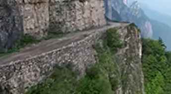
How to drive the cliff-hanging road to Xifanggoucun in the Daba Mountains?
Xifanggoucun is a remote mountain village located in Ningqiang County, Shaanxi province, China. The road to the settlement is a 6,000-meter concrete track carved into the vertical cliffs of the Daba Mountains. It is one of the most extreme tunnel roads in China, featuring hand-carved passages that hang 3,000ft above the valley floor.
How to drive the unpaved road to Bod La and Gong La?
The road from Lakangzhen to Gong La is a high mountain track located in Lhozhag County, within the Shannan Prefecture of Tibet. Starting from the G219 highway, this 58.8 km unpaved route is a mining track that crosses two high-altitude passes near the Bhutanese border.
How to drive the 64km unpaved mountain road to Lenglongling Pass
Lenglongling Pass is a high mountain pass at an elevation of 4,254 meters (13,956 ft) above sea level, located on the border between Qinghai and Gansu provinces in China.
How to drive the 100 hairpin turns to Chuti Chang La?
Chuti Chang La is a high mountain pass at an elevation of 5,047m (16,558ft) above sea level, located on the Line of Actual Control (LAC) between Tibet and Ladakh.
Driving the Songkan River Cliff Road in Guizhou
The Songkan River Cliff Road is located in the Qijiang District of the Guizhou province, China. Built directly into the vertical rock walls of a steep canyon, this narrow passage is part of the country's legendary "wall-hanging" roads created to break the absolute isolation of remote mountain communities. It’s one of the most famous Chinese tunnel roads.
Driving the Gokarla Tunnel: The world's longest high-altitude road tunnel
The Gokarla Tunnel is a high mountain tunnel located in the Tibet Autonomous Region. Situated on the Lhasa-Tsethang Highway, this infrastructure project took seven years to complete due to the difficulties of drilling through the mountains at an average altitude of 4,300 meters (14,107 ft) above sea level.
How to drive the unpaved X607 County Road in Tibet?
The X607 (County Road 607) is a high-altitude dirt road located in Nyima County, Tibet, reaching a maximum elevation of 5,089m (16,696ft) above sea level.
How to drive the unpaved road to Nangpa La?
Nangpa La is a high mountain pass at an elevation of 4,884m (16,023ft) above sea level, located in Baiyü County, in the western part of the Sichuan province, China.
How to drive the unpaved road to Zǔsōng La in the Gangdise Mountains?
Zǔsōng La is a high mountain pass at an elevation of 5,775m (18,946ft) above sea level, located in Coqên County, Tibet. It’s one of the highest roads in the world.
How to drive the 62-hairpin turns to Boi La in Tibet?
Boi La is a high mountain pass at an elevation of 4,950 meters (16,240 ft) above sea level, located in Cona County, Tibet. The road to the summit is a raw, unpaved track through a series of 62 sharp hairpin turns.
How to drive the desert track to Karatagh La?
Karatagh La is a high mountain pass at an elevation of 5,473m (17,956ft) above sea level, located in the Aksai Chin region of Tibet.
Driving the military roads to Tangkar La on the India-China border
Tangkar La is an international high mountain pass located on the rugged border between India and China. The pass features two separate unpaved military access tracks that climb the mountain slopes from each country, meaning the roads do not connect or cross the international border at any point.
Driving the military road to the international Kasa Irunun Beli Pass
Kasa Irunun Beli Pass is a high mountain pass at an elevation of 4,691 meters (15,390 ft) above sea level, located on the restricted border between Tajikistan and China. The extreme altitude and the sensitive border location make it one of the most restricted drives in Central Asia.