What are the most spectacular roads in Peru?
Located in the heart of the Andes, in the western part of South America, Peru is very challenging for drivers due to its geography that comprises the coast, the Andes Mountains, and the Amazon Rainforest. With such topography, it has more than 230 roads listed as the most spectacular in the world.
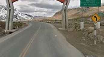
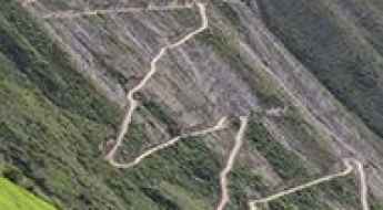
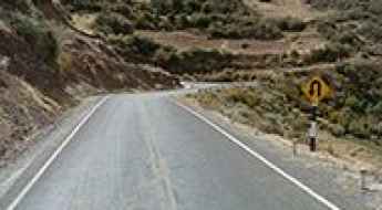
When traveling to the country, you can’t miss Curvas de Huanchaca, a series of 24 hairpin turns located on the boundary between Cusco and Apurimac. It’s one of the most hairpinned roads in the world, offering travelers a spectacular, vertigo-inducing drive. Or the harrowing paved road to Anticona Pass in the Andes, at an elevation of 4,824m (15,826ft) above sea level. The pass is often incorrectly said to be the highest paved road in South America.
If you want to try scary drives, don’t forget the Pasamayo Serpentine, a lethal coastal road known for fatal traffic accidents. The road has no safety fences, and one mishap, and you plunge off the cliff and into the sea. Or Pato Canyon Road, a path hewn out of sheer rock, located in the Ancash Region. And if you’re up for paved mountain roads, don’t miss the awe-inspiring drive to Punta Olímpica in the Andes, climbing up to 4,732m (15,525ft) above sea level. It's one of the highest paved roads in the country.
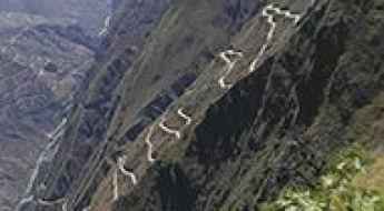
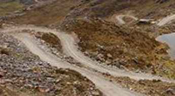
Curvas de Huanchaca: 24 Switchbacks on a Narrow and Steep Road
Curvas de Huanchaca is the name of a series of 24 hairpin turns located on the boundary of Cusco and Apurimac regions, in Peru. The ideal time to travel is during daylight, and night driving is not advised. It’s one of the most hairpinned roads in the world, offering travelers a spectacular and vertigo-inducing drive.
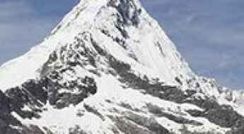
Can I drive to the Paramount Pictures logo mountain?
Artesonraju is a mountain peak located in the Caraz District in the southeastern part of the Huaylas Province, Peru. It has been suggested that the peak is the mountain depicted in the live-action Paramount Pictures logo.
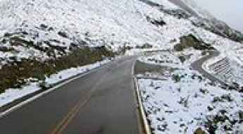
A hairy paved road to Anticona Pass in the Andes
Abra Anticona is a high mountain pass at an elevation of 4,824m (15,826ft) above sea level, located on the boundary between the Lima and Junin regions of Peru. The pass is incorrectly said to be the highest paved road in South America.
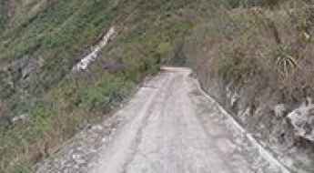
The road to Machu Picchu is pure adventure
Machu Picchu is a 15th-century Inca site at an elevation of 2,430m (7,970ft) above sea level, located in the Urubamba Province of Peru.
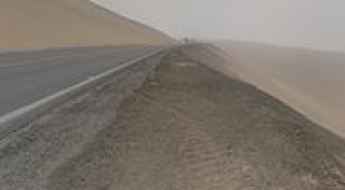
Pasamayo Serpentine is a lethal coastal road in Peru
Serpentín Pasamayo is a very dangerous coastal road located in the Lima Province of Peru, known for fatal traffic accidents. The road has no safety fences. One mishap, and you plunge off the cliff and into the sea.
What are the highest roads in Peru?
Located in western South America, Peru extends for nearly 1,500 miles along the Pacific Ocean, but its true geographical identity lies in its vertical core: the Andes Mountains. This immense, ice-capped range defines the nation, running parallel to the coast and creating some of the most spectacular high-altitude landscapes on Earth. With numerous peaks soaring above 20,000 feet, the Peruvian Andes are not merely a barrier, but a vast, elevated territory. This challenging topography has necessitated the construction of an extraordinary network of high-mountain roads, inviting drivers to conquer passes that rank among the highest and most remote motorable routes in the world.
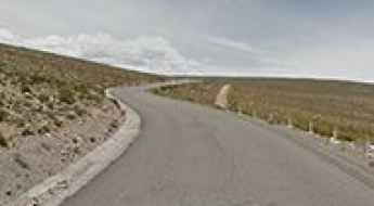
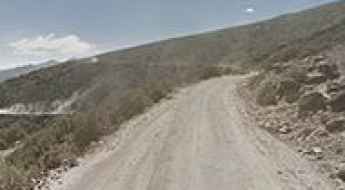
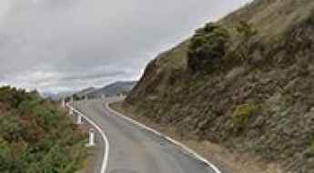
The Ultimate Road Trip from Chivay to Arequipa
Carretera Chivay-Arequipa is the name of a spectacular curvy mountain road located in the Arequipa region of Peru.
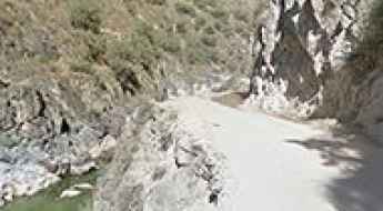
Pato Canyon Road is a path hewn out of sheer rock
Cañón del Pato (Spanish for Duck Canyon) is a scenic but dangerous canyon located in the Huaylas Province of the Ancash Region in Peru.
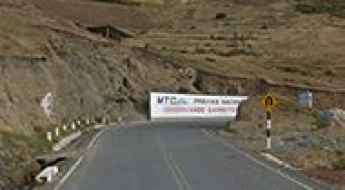
An awe-inspiring drive to Punta Olimpica in the Andes
Punta Olimpica is a high mountain pass at an elevation of 4,732m (15,525ft) above sea level, located in Ancash, Peru. It's one of the highest paved roads in the country.
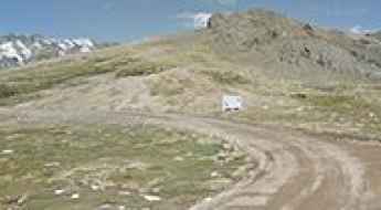
Driving the hairy road to Portachuelo Pass in the Andes
Paso Portachuelo Llanganuco is a high mountain pass at an elevation of 4,717m (15,475ft) above sea level, located in the Yungay province of Peru. It’s one of the most hairpinned roads in the world.
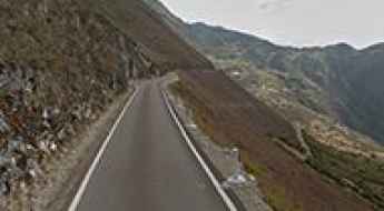
Driving the hairy road from Santa Maria to Santa Teresa in Peru
Carretera Santa María-Santa Teresa is a very scary drive with dangerous drops, located in the Cusco Region, in the central part of Peru.
An exciting drive to the top of Abra Malaga Pass
Abra Malaga is a high mountain pass at an elevation of 4,343m (14,248ft) above sea level, located in the Cusco Region of Peru.
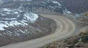
Patapampa Pass is one of the highest paved passes in the Americas
Abra Patapampa is a high mountain pass at an elevation of 4.879m (16,007ft) above sea level, located in the Caylloma province of the Arequipa region, in Peru. It’s said to be one of the highest paved passes in the Americas.
Driving the curvy road to Mirador Cruz del Condor in the Andes
Mirador Cruz del Cóndor is a natural vantage point at an elevation of 3.794m (12,447ft) above sea level, located in the Department of Arequipa, Caylloma province, Peru. The lookout is the most popular place for condor watching.
Oquepuño Pass is one of the highest paved roads of South America
Abra Oquepuño is a high mountain pass at an elevation of 4.883m (16,020ft) above sea level, located in the province of Carabaya, in Peru. It’s said to be one of the highest paved roads of South America.
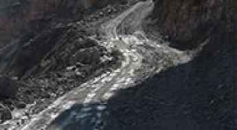
Driving Ruta 3N with vertigo-inducing depths of up to 1.000m
Located in the region Ancash of Peru, the defiant Carretera 3-N is one of the most dangerous roads in the world, with vertigo-inducing depths of up to 1.000m.
The Wild Road to Abra Huayraccasa
Abra Huayraccasa is a high mountain pass at an elevation of 4.971m (16,309ft) above sea level, located in the region Huancavelica, in Peru.
La Rinconada in Peru is one of the highest towns accessible by car
La Rinconada is a small mining town at an elevation of 5.130m (16,830ft) above sea level, located in the Ananea District, San Antonio de Putina Province, in Puno region of Peru. It’s one of the highest towns accessible by car on Earth.
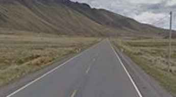
Driving the paved road to La Raya Pass in the Andes
Abra la Raya is a high mountain pass at an elevation of 4.352m (14,278ft) above sea level located on the boundary between Puno and Cusco regions in Peru.
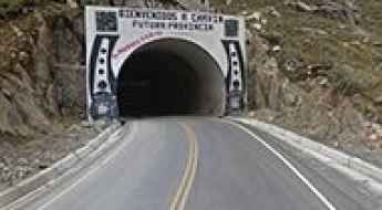
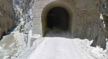
Kahuish Tunnel is one of the world's highest tunnels
Tunel de Kahuish is a high mountain tunnel at an elevation of 4.516m (14,816ft) above sea level, located in Ancash, a region of Peru. It’s one of the world's highest tunnels.
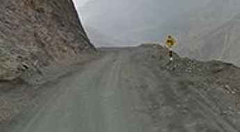
Driving 25km above 4,900m on the gravel road to Peru's Abra Azuca
Abra Azuca is a high mountain pass at an elevation of 5.190m (17,027ft) above sea level, located in Peru in Departamento de Apurimac, on the boundary between Cusco and Apurimac regions. It's one of the highest roads in Peru.
Driving to Punta Callan through one of the windiest roads ever built
Punta Callán is a high mountain pass at an elevation of 4.228m (13,871ft) above sea level, located in the Ancash Region of Peru.
LM-106 is a Peruvian epic road through the iconic Catajambo Canyon
Carretera 106 (LM-106) is a very challenging road straddling Ancash and Lima regions of Peru.
Iquitos: The Largest City in the World Without Road Access to the Outside
Located in the northern Amazon region of Peru, Iquitos is the largest city in the world with no roads connecting to other regions or countries. The city can only be reached by boat, plane, or a cul-de-sac road, that links only one town.
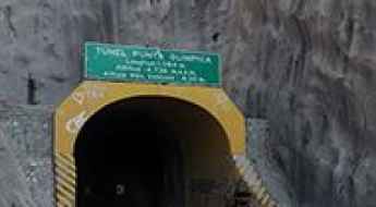
Punta Olimpica is the highest tunnel in the Americas
Located in the region of Ancash of Peru, Punta Olimpica Tunnel is one of the highest vehicular tunnels in the world, at an elevation of 4.735m (15,535ft) above sea level.
The Thrilling Road of Mantaro River Canyon: A Test of Nerves and Courage
Cañon del Río Mantaro is a scenic canyon located in the Huancavelica region of Peru. The road through the canyon is extreme and not for everybody..
The Road to Salinas Lake is One of the Toughest Tracks in the World
Laguna de Salinas is a salt lake at an elevation of 4,335 meters (14,222 feet) above sea level, located in the Arequipa Region of Peru.
A memorable road trip to Acumulacion Mariela Mine
Mina Acumulación Mariela is an open-pit mine at an elevation of 5,298m (17,381ft) above sea level, located on the boundary between the Puno and Moquegua regions of Peru. It’s one of the highest roads in the country.
Driving the Dizzying Road to Cotahuasi Canyon
Cañon de Cotahuasi is a very scenic yet challenging canyon located in the Department of Arequipa, in the Province of La Union, Peru. It’s said to be the deepest canyon in the Americas.
The paved road from Balzas to Celendin in northern Peru is not an easy drive
Located in the region of Cajamarca, in the northern part of Peru, the road from Balzas to Celendín tests the skill, and courage, of any driver. Hair raising stuff. There is absolutely no room for mistakes.
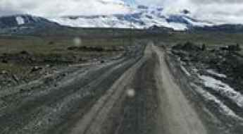
How to get by car to Lake Junin in central Peru?
Lago Junín is a high mountain lake at an elevation of 4,182m (13,720ft) above sea level, located in the Junín Region of Peru.
Driving the road from Celendin to Yerbabuena: absolutely no room for mistakes
Carretera Celendín-Yerbabuena is a very scary winding mountain road located in the region of Cajamarca, in Peru. Hair raising stuff! There is absolutely no room for mistakes.
The Road from Pusac to Uchumarca is Recommended for Drivers with Strong Nerves
Carretera Púsac-Uchumarca is a high mountain road located in the Bolívar Province of Peru. This road tests the skill and courage of any driver. It’s definitely not for those suffering from vertigo or a fear of landslides.
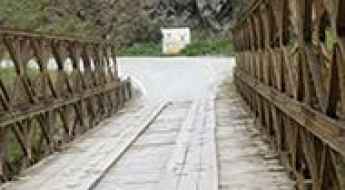
Puente San José: The wooden bridge over the Inambari River
Puente San José is a high-risk crossing located within the Bahuaja Sonene National Park, in the Sandia Province of Peru. Situated near the Bolivian border, this structure is an essential but precarious link on the unpaved Carretera 34H, connecting San Juan del Oro and Sandia. The physical reality of crossing this bridge involves driving over a 39.62-meter span made of aged wooden planks and a rusted metal frame, making it one of the most spectacular bridges in the world due to its fragile state and the sheer drop over the Inambari River.
Drive Across the Abra Chonta Pass in the Andes
Abra Chonta is a high mountain pass at an elevation of 4,875 m (15,994 ft) above sea level, located in the Huancavelica Region of Peru.
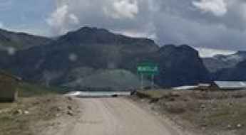
How to Get to Chiquian by Car?
Chiquián is a high mountain town at an elevation of 3,410 m (11,187 ft) above sea level, located in the Ancash Region of Peru.