What are the most spectacular roads in Peru?
Located in the heart of the Andes, in the western part of South America, Peru is very challenging for drivers due to its geography that comprises the coast, the Andes Mountains, and the Amazon Rainforest. With such topography, it has more than 230 roads listed as the most spectacular in the world.
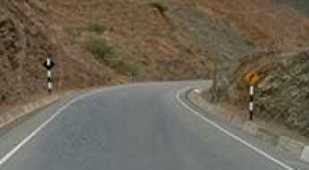
When traveling to the country, you can’t miss Curvas de Huanchaca, a series of 24 hairpin turns located on the boundary between Cusco and Apurimac. It’s one of the most hairpinned roads in the world, offering travelers a spectacular, vertigo-inducing drive. Or the harrowing paved road to Anticona Pass in the Andes, at an elevation of 4,824m (15,826ft) above sea level. The pass is often incorrectly said to be the highest paved road in South America.
If you want to try scary drives, don’t forget the Pasamayo Serpentine, a lethal coastal road known for fatal traffic accidents. The road has no safety fences, and one mishap, and you plunge off the cliff and into the sea. Or Pato Canyon Road, a path hewn out of sheer rock, located in the Ancash Region. And if you’re up for paved mountain roads, don’t miss the awe-inspiring drive to Punta Olímpica in the Andes, climbing up to 4,732m (15,525ft) above sea level. It's one of the highest paved roads in the country.
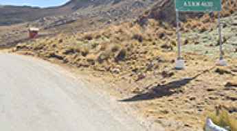
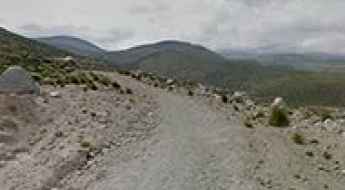
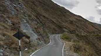
Abra Ojelaca is a paved road heading deep into the high mountains
Abra Ojelaca is a high mountain pass at an elevation of 4.606m (15,111ft) above the sea level, located in the Andes of southern Peru, in the Moquegua Region.
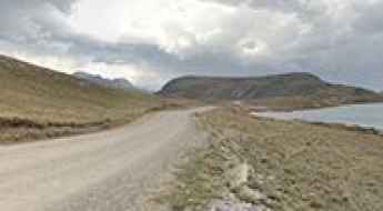
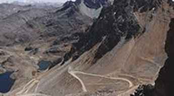
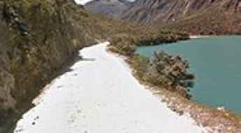
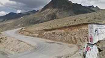
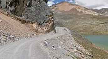
HU-110: Driving the high-altitude lake route in the Peruvian Andes
The HU-110 is a remote high mountain road located in the heart of the Peruvian Andes. This unpaved route is famous for its dramatic scenery, connecting the town of Antacolpa with the border of the Lima region while passing through a spectacular chain of glacial lakes at extreme altitudes.
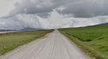
Driving Route PE-20C: The Unpaved 116 km Mountain Road in Peru
Ruta Nacional PE-20C is a high-altitude mountain road straddling the Lima and Pasco regions in east-central Peru. The route connects the Pacific coast watershed with the high Andean plateau, running through the western range of the Andes.
Abra Huarapasca
Punta Huarapasca is a high mountain pass at an elevation of 4.815m (15,797ft) above the sea level, located in the Huascarán National Park of Peru.
Abra Yanashalla: The Ultimate Road Trip Guide
Abra Yanashalla is a high mountain pass at an elevation of 4.689m (15,384ft) above the sea level, located in the Ancash department, in Peru.
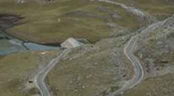
A pretty unpaved road to Laguna Marcapomacocha
Laguna Marcapomacocha is a high mountain lake at an elevation of 4.470m (14,665ft) above the sea level located in Yauli Province in the Junín Region in Peru.
The Scenic Unpaved Road to Vientos Pass in the Andes
Paso El Viento is a high mountain pass at an elevation of 5,012m (16,443ft) above sea level, located in Palca District of Tacna Province, in Peru. It’s one of the highest roads in the country.
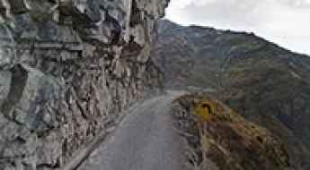
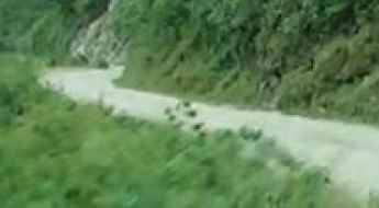
Driving the narrow cliff road to San José de Parac in Peru
San José de Parac is a high-altitude mountain settlement sitting at 3,815 meters in the San Mateo District of Huarochirí, Peru. The track leading to the town is a brutal example of Andean cliff engineering, where the road is literally carved into the side of a vertical mountain. This is a technical grind where you are squeezed between a solid rock wall and a drop of hundreds of meters, requiring total concentration and a vehicle that can handle tight, manual maneuvers on the very edge of the abyss.
Palambla-Huancabamba Road
Pista Palambla-Huancabamba is a high mountain track located in the province Huancabamba, in Northern Peru. In many places the road is bordered by a drop of hundreds of meters (many hundreds of feet) unprotected by guardrails. Words can’t describe the road and pictures don’t do it justice.
Quebrada Honda
Quebrada Honda is a high mountain peak at an elevation of 4.901m (16,079ft) above the sea level, located in the Carhuaz Province, in the Ancash Region of Peru.
How to get by car to Abra Condorillo?
Abra Condorillo is a high mountain pass at an elevation of 4.993m (16,381ft) above sea level, located in the Arequipa region of Peru.
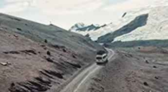
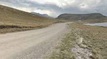
Driving the paved 20A road to Laguna La Viuda and Laguna Chuchon
Laguna La Viuda and Laguna Chuchon are two high-altitude glacial lakes located in the Cordillera de la Viuda, within the Lima Region of Peru. The lakes are accessed via Route 20A, a paved mountain road that crosses the Western Andes at over 4,500 meters above sea level.
Don Mario and Punta Pumacocha: The grueling 42km 4x4 crossing in Peru
Crossing the rugged border between the Lima and Junin regions in central Peru is a task for the most experienced off-roaders. This 42km high-altitude traverse takes you over two massive passes: Don Mario Pass and Punta Pumacocha. Reaching nearly 5,000 meters, this is a remote mining corridor where the thin air and extreme gradients create one of the most demanding driving environments in the Andes.
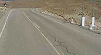
How to drive the cracked road to Abra Negro Bueno in the central highlands?
Abra Negro Bueno is a high mountain pass situated at 4,648m (15,249ft) above sea level, nestled in the central Peruvian Andes.
The Road to Caliz Pass in the Andes: Be Ready to Make Room for Oncoming Vehicles
Paso Caliz is a high mountain pass at an elevation of 5,206 meters (17,080 feet) above sea level, located on the boundary between the Canchis and Quispicanchi provinces of Peru. It is one of the highest roads in the country.
Volcanos Valley Road, one of the world's top drives
Carretera del Valle de los Volcanes is a high mountain road located in the province of Castilla, in Arequipa, in southern Peru. The drive is a great tourist circuit offering more than 85 volcanic cones.
Llanganuco Chinancocha
Llanganuco Chinancocha is a high mountain crystal blue lake located in the Cordillera Blanca in the Andes of Peru at an elevation of 3.850m (12,631ft) above the sea level.
Andahuaylas Airport
Located in the Andahuaylas Province in the Apurímac Region, in Peru, the Andahuaylas Airport is a high mountain airport at an elevation of 3.444m (11,300ft) above the sea level.
Abra de Porcuya
Abra de Porcuya is a high mountain pass at an elevation of 2.137m (7,011ft) above the sea level, located in the province Huancabamba in Peru.
Laguna Pallarcocha: Driving the remote AR-107 to 4,740m in Peru
Laguna Pallarcocha (also known as Laguna de Payarcocha) is a high-altitude lake at elevation of 4,740m (15,550ft) above sea level, hidden in the Condesuyos Province of the Arequipa Region. Situated in the southern Peruvian Andes, the journey to this remote body of water is a grueling test of endurance, crossing a barren and windswept landscape.
Road 101
Located in the province of Pallasca in Peru, Carretera 101 is one of the most dangerous roads in the world. There are vertigo-inducing depths of up to 1.200m. Only the suicidal, the insane, or the paid-to-do-this should ever drive down.
Abra Rit'ipata
Abra Rit'ipata is a high mountain pass at an elevation of 4.947m (16,230ft) above the sea level, located in the Apolobamba mountain range in the Andes of Peru.

Road 38
Located between the departments of Tacna and Puno, in the Andean Cordillera, near Peru’s border with Bolivia, Carretera 38 is an extreme high mountain road running entirely over the 3.200m above the sea level.
Salkantay Refuge
Refugio Salkantay is a high mountain refuge at an elevation of 3.849m (12,627ft) above the sea level, located in the Cusco Region, in Peru. Your wheels will be astounded at the wonderful views of the mountains spread out before you! They are terrible for drivers who are prone to vertigo. In many places the road is bordered by a drop of hundreds of meters (many hundreds of feet) unprotected by guardrails.
Road 110
Carretera 110 is a high mountain road located in northern Peru. Hair raising stuff ! There is absolutely no room for mistakes.
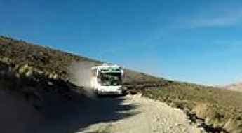
How to drive the unpaved LM-120 from Tinco to San Mateo?
The LM-120 is a long-distance high-altitude mountain road located in the Lima Department of Peru. The unpaved route runs for 140 kilometers (87 miles) across the Andes range to connect the settlements of Tinco and San Mateo, tracking through narrow dirt ledges and high mountain passes.
Driving the paved AN-110 road to Laguna de Querococha
Laguna de Querococha is a high-altitude glacial lake located in the Ancash Region of northern Peru. Situated within the Huascarán National Park in the Cordillera Blanca range, the lake sits along the paved AN-110 mountain highway at an elevation of 3,980 meters (13,060 ft) above sea level.
Road Lima-108
Carretera LM-108 is a mountain road located in central Peru, in the region Lima. There are some narrow sections impassable for two cars at the same time.
Abra Huamanripa
Abra Huamanripa is a high mountain pass at an elevation of 4.879m (16,007ft) above the sea level, located in the Departamento de Ancash, Peru.
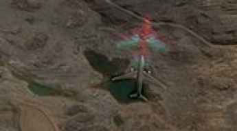
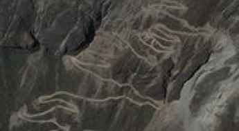
The Mysterious Plane in the Andes: A Google Earth Mystery
Google Earth often displays unusual sights during virtual exploration. In the Andes of Peru, the silhouette of a large aircraft appears in a remote high-altitude location, creating interest among virtual travelers.
Abra Chucopampa
Abra Chucopampa is an extreme high mountain pass at an elevation of 4.858m (15,938ft) above the sea level, located in the Cajamarca department, in Peru. The climb is brutal and cruel.
The Wild Road to Cañon Tablachaca
Located on the border of La Libertad and Ancash regions in northwestern Peru, Tablachaca Canyon has been carved by the Tablachaca river over millions of years.
Laguna de Choclococha
Laguna de Choclococha is a high mountain lake at an elevation of 4.529m (14,858ft) above the sea level, located in the province of Castrovirreyna in Peru.
Travel Guide to Abra Milloc in the Andes
Abra Milloc is a high mountain pass at an elevation of 4,826m (15,833ft) above sea level, located in the Andes of Peru.
Laguna Yantac
Laguna Yantac is a high mountain lake at an elevation of 4.641m (15,226ft) above the sea level located in the Andes, in the Yauli Province in the Junín Region in Peru.
How to drive the paved road to Abra Lliullita in the Andes?
Abra Lliullita is a high mountain pass at an elevation of 4,645m (15,239ft) above sea level, located in the heart of Apurímac Department in Peru.