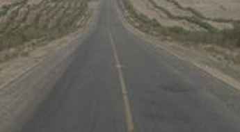
What are the most spectacular roads in China?
Located in the eastern part of Asia, and bordering 14 countries, China covers 9.6 million square kilometers. It’s the world's third-largest country by land area and it hosts more than 500 brutal driving experiences, listed as the most spectacular roads in the world. Due to its size and difficult geography, featuring mountains, plateaus, deserts, and plains, it has scenic, mountainous, and even flooding roads. It also holds many records, such as the world's longest traffic jam: a 100 km, 12-day standstill that occurred in August 2010, when the country witnessed the mother of all traffic jams.
When travelling to China, you can’t miss the infamous Tian Men Shan Big Gate, a road with 99 turns, built in 1998, that offers a thrilling 11-kilometer journey; or the iconic Guoliang Tunnel, which was dug through the side of a mountain by hand. Built in the early 1970s it is one of the most famous Chinese tunnel roads. It’s also worth driving the Sichuan-Tibet Highway, one of the world's highest roads.
And if you like challenging mountain roads situated at high elevations, remember to check out our list with the highest roads in China, where you’ll find real gems, such as Chāmkang, a mountain pass at 5.953m (19,530ft) above sea level.
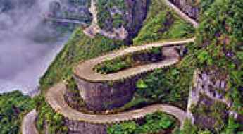
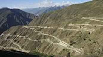
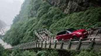
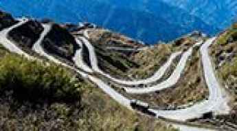
Tian Men Shan Big Gate is the road with 99 turns
Tian Men Shan Big Gate Road is a winding drive with 99 turns located in Tianmen Mountain National Park of China. From its construction in 1998 to the 11-kilometer journey, this road offers a unique experience.

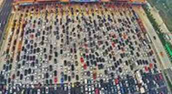
The World's Longest Traffic Jam: A 100km, 12-Day Standstill in China
In August 2010, China witnessed the creation of the mother of all traffic jams, an epic event that unfolded over 12 agonizing days. The chaos extended over an astonishing 62 miles (100 km), marking it as the longest traffic jam in recorded history. As vehicles came to a standstill along the China National Highway 110, a makeshift economy emerged, offering overpriced essentials like food, water, and cigarettes.
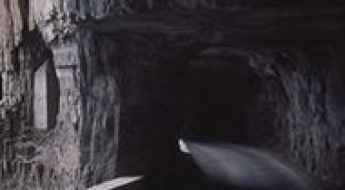
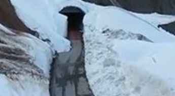
Guoliang Tunnel was dug through the side of a mountain by hand
Located in the northwest of Henan province, in China, Guoliang Tunnel is famous for its dangerous location and difficult construction. Built in the early 1970s, it has been dubbed as the road that does not tolerate any mistakes. It’s one of the most famous Chinese tunnel roads.
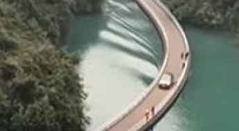
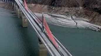
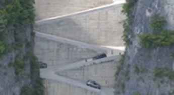
Driving on water surface through the Shiziguan floating bridge
Located in Xuan'en County of southwestern Hubei province, in People's Republic of China, the Shiziguan floating bridge is one of the most spectacular bridges in the world.

The historic Burma Road was built during World War II
The Burma Road was a crucial supply route built during World War II, linking Lashio in eastern Burma (now Myanmar) with Kunming in Yunnan province, China.
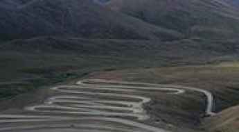
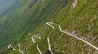
Driving the 208 Bends of the Panlong Ancient Road
Located in the Kashgar region of the Xinjiang Uygur Autonomous Region in China, the Panlong Ancient Road is not for the faint of heart or anyone prone to motion sickness.
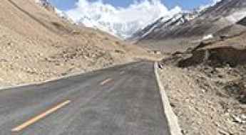
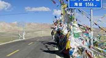
Sichuan-Tibet Highway is one of the world's highest roads
Sichuan-Tibet Highway is a high mountain road located in China. Nonetheless, it’s a regular route for truck drivers heading to the roof of the world.
Road trip guide: Conquering China National Highway 219
High altitude, thin, freezing dry air; intense harsh sunlight, galeforce winds with sub-zero windchill for hundreds and hundreds of kilometres. China National Highway 219 (G219) is a true adventure.
The Friendship Highway: The Ultimate Overland Guide from Lhasa to Nepal
The Friendship Highway (part of the G318 National Highway) is widely regarded as one of the most spectacular overland journeys on Earth. Connecting Lhasa, the capital of Tibet, with the Nepalese border, this 800-kilometer (500-mile) route traverses the high-altitude heart of the Himalayas, offering front-row views of the world's highest peaks.
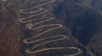
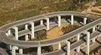
Driving the winding and hairpinned 24-Zig Road in China
Located near Qinglong town in Guizhou Province, 24-Zig Road is a curvy mountain road with 24 hairpin turns. The road was built by the Chinese during WWII to transport supplies to help resist the Japanese invasion. It’s one of the most famous hairpinned roads in the world.
Heaven's Gate is one of China’s most famous landmarks
Located in the Hunan Province of China, Heaven's Gate is one of the most famous landmarks in the country.
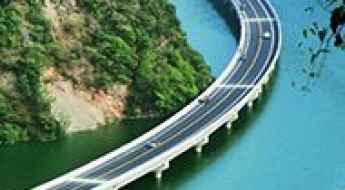
Over-Water Highway runs along the middle of a river valley in China
Located in the Guzhao district of Hubei province, in central China, Over-Water Highway is the name of a motorway completely built over water. It’s one of the world’s most scenic drives.
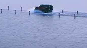
Yongwu Road is the most beautiful road under water
Located in Yongxiu County, in northern Jiangxi province of People's Republic of China, a road built across Poyang Lake is flooded every year. It’s one of the periodically flooded roads around the world.
Driving the National Highway 318 from China to Nepal
China National Highway 318 (G318), the Shanghai-Tibet Highway, is 5,476 kilometers (3,403 miles) long, running from Shanghai to the international border with Nepal. The route is the main commercial road into the Tibetan plateau.
The Ultimate Guide to Traveling the Yaxi Highway
Located in southwest China's Sichuan province, the Yaxi Highway is an engineering marvel with 270 viaducts and 25 tunnels.
Experience the Majesty of the Tianlongshan Highway: China's Road Above the Clouds
Dubbed as the highway above the clouds, the Tianlongshan Highway is a marvel of engineering located in Jinyuan District, in China.
What are the highest roads in China?
Located in East Asia, the People's Republic of China is the world's third-largest country by land area, boasting unparalleled topographical diversity. A staggering 65 percent of its landmass is covered by mountains, plateaus, and hills, creating one of the most vertically extreme nations on Earth. This immense scale is dramatically capped by the vast Qinghai-Tibet Plateau and the Himalayan ranges, home to dozens of peaks over 8,000 meters.
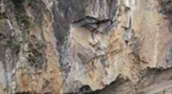
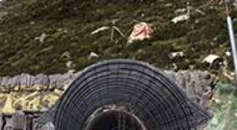
China's Engineering Marvels: Driving The 24 Most Daring Tunnel Roads
China is home to some of the most extreme tunnel roads in the world, built through sheer cliffs and rugged mountains. In remote areas like the Taihang Mountains, entire villages were once cut off, with only steep, dangerous footpaths as access. To connect these communities, locals took matters into their own hands, carving tunnels straight through the rock.
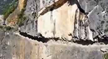
The awesome Lanying Cliff Road carved out of the mountains
Located in Wuxi County, in China, the infamous Lanying Cliff Road is an awesome path carved out of the mountains. It’s one of the famous Chinese tunnel roads.
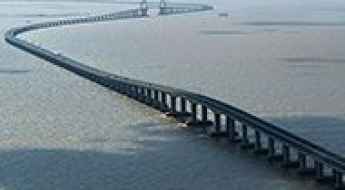
Hangzhou Bay Bridge is the longest ocean-crossing bridge
Located in the eastern coastal region of China, the Hangzhou Bay Bridge spans across the Hangzhou Bay and is one of the most spectacular bridges in the world.
An Unforgettable Drive to Gyatso La Pass on the Tibetan Plateau
At an elevation of 5,248m (17,217ft) above sea level, Gyatso La is the highest mountain pass along the legendary Friendship Highway (G318) in Tibet. Known as the gateway to the Everest region, it is a place where oxygen is scarce and the landscape is defined by its extreme desolation.
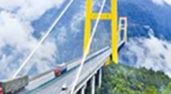
The spectacular Sidu River Bridge in China is the highest bridge in the world
Hubei Enshi Sidu River Bridge is located in Badong County of the Hubei Province of China. It opened in November 2009 and was the world’s highest bridge, rising more than 1,500 feet in the air. It’s one of the most spectacular bridges in the world.
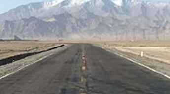
Tarim Desert Highway is China's longest desert road
Located in northwest China's Xinjiang Uygur Autonomous Region, Tarim Desert Road is the name of a paved road running across the Taklamakan, China’s largest desert.
Tuen Mun Road in Hong Kong is haunted by ghosts
Tuen Mun Road is a very congested highway located in Hong Kong, linking Tuen Mun and Tsuen Wan. Local folklore says it’s haunted by the ghosts of those who have been killed while traveling on it. It's considered one of the Top Haunted Roads in the world.
A paved road to Everest Base Camp, the Roof of the World
Located in the Tibet Autonomous Region of the People’s Republic of China, the Mount Everest Base Camp sits at an elevation of 5.157m (16,919ft) above sea level. The road to the base camp is a magnificent feat of engineering. It’s mostly paved.
The road with 64 switchbacks to Pang La
Pang La is a high mountain pass at an elevation of 5.205m (17,076ft) above sea level, located in Tingri County, under the administration of the prefecture-level city of Xigazê in the Tibet Autonomous Region of China.
Semo La: Driving one of the highest paved passes in the world
Reaching an elevation of 5,578m (18,300ft) above sea level, Semo La (also known as Sangmu La) is one of the highest roads in the world accessible by a paved surface. Located in Coqên County, within the Ngari Prefecture of the Tibet Autonomous Region, this pass is a legendary crossing on the Tibetan Plateau, offering a mix of extreme altitude and total isolation. It’s one of the highest roads in the country.
The Beijing-Zhuhai Expressway is one of the most congested roads on Earth
The Beijing-Zhuhai Expressway ranks among the most congested roads on Earth. While the road is fully paved and boasts up to 50 lanes in some sections, post-holiday traffic is notoriously challenging.
Zhongnanshan Tunnel is An Engineering Marvel in China's Shaanxi Province
The Zhongnanshan Tunnel, located in the Qinling Mountains in Shaanxi Province of China, connects Xi’an and Ankang. Running beneath Mount Zhongnan, it is one of the longest tunnels in the world.
Driving the Chamkang Pass: One of the World's Highest Roads
Chamkang is a high mountain pass at an elevation of 5,953 meters (19,530 feet) above sea level, located on the border between Xinjiang and Tibet in China. It is probably the world's highest motorable road.
G217 is a Chinese remote paved road
China National Highway 217 (G217) is a challenging road located in southwest Xinjiang Uyghur Autonomous Region, in the northwestern part of China.
The Ultimate Road Trip To Suge La Pass in Tibet
Suge La is a high mountain pass at an elevation of 5,453m (17,890ft) above sea level, located in the Tibet Autonomous Region of the People's Republic of China.
Driving one of the world's highest motorable roads to Lajiong La
Lajiong La is a high mountain pass at an elevation of 5.830m (19,127ft) above sea level located in Coqên County, in the Ngari Prefecture, in the Tibet Autonomous Region of China. It's one of the highest motorable roads in the world.
How to drive to Wenquan, one of Earth's highest road-accessible towns?
Wenquan is a high mountain town at an elevation of 5.100m (16,732ft) above sea level located in the Qinghai province of China. It’s one of the highest towns accessible by car on Earth.
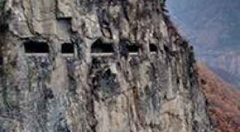
Kunshan Tunnel Road is China's Handmade Marvel Constructed by Farmers
Located in Henan Province, the Kunshan Tunnel Road is one of China's iconic tunnel roads. Unique features include cliff-facing windows made for the disposal of rock debris.
How To Have The Ultimate Road Trip To Jelep La Pass
Jelep La is an international high mountain pass at an elevation of 4,434m (14,547ft) above sea level, located on the border of India and China.
Driving the scary Wuxi's Token Stone Road in Chongqing
Wuxi's Token Stone Road is a very defiant and thrilling drive located in the Chongqing region of China. 1st gear only. Due its narrowness, it is impossible to turn back.
Sky Road is a drive with harrowing zig-zags
Located in western Hubei's Enshi Tujia and Miao Autonomous Prefecture, in central China's Hubei Province, the Sky Road is a marvel of engineering.
Cho La Mountain Tunnel is one of the world’s highest tunnels
The Cho La Mountain Tunnel is a high mountain tunnel at an elevation of 4.378m (14,363ft) above sea level, located in the Cho La Mountains of western Sichuan Province, in China.