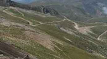
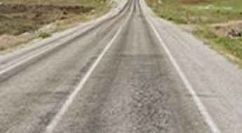
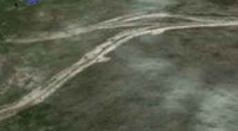
What are the most spectacular roads in Turkey?
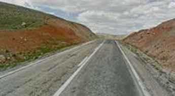
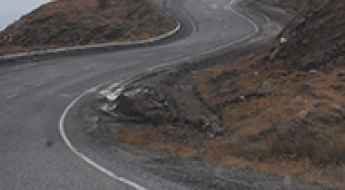
Straddling Europe and Asia, Turkey is one of the most exciting countries in the world to drive, and a must on any driver’s list. First on the list must be the challenging D915 (Bayburt-Of) Road. It stands as one of the world's most challenging roads, nestled between the Black Sea and the Northeast Anatolia regions. This road is for experts only.
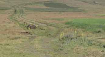
Covering an area of 783,356 square kilometers and sharing borders with eight countries, Turkey is home to about 200 roads listed as the most spectacular in the world. For the bravest drivers, the dangerous Kemaliye Stone Road above the Euphrates River is one of the most extreme roads in the world. This handmade road is for drivers with strong nerves only, with drops of hundreds of meters, unprotected by guardrails, and 38 unlit tunnels. The construction of the road started in 1870 and was finished in 2002. The road to Kus Yuvasi Pass will take your breath away. At 1,388m (4,553ft) above sea level, the pass is located in the Mediterranean Region of the country.
The Karabet Geçidi, at 2,994m (9,822ft) above sea level in Van Province, is one of Europe's highest paved roads, offering panoramic views. If the previous roads are not enough, the country is home to Gök Dağ, one of the highest roads in Europe, climbing up to 3,417m (11,210ft) above sea level. There are many construction companies established in Turkey that worked for building the new, better roads that attract many tourists each year.
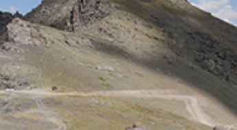
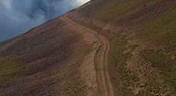
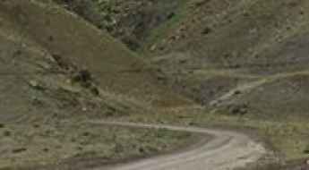
Driving the steep 4x4 track to Yedigöller in Erzurum
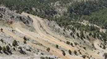
Yedigöller is a high-altitude cluster of seven glacial lakes hidden deep in the Erzurum Province of Eastern Anatolia. Reaching an elevation of 3,173 meters, the track to these lakes is one of the highest and most aggressive climbs in Turkey. This is a raw, unpaved mountain road that demands absolute respect from the driver; it is a landscape of jagged rock and thin air where the wind never stops and the terrain is constantly trying to push your vehicle to its limit.
Aladaglar National Park roads
Established in 1995, Aladaglar National Park is a national park located within the borders of Niğde, south of Kayseri and Adana provinces in the Mediterranean region of Turkey.
Driving the rough and rocky road to Karagöl Lake in Giresun
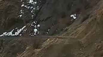
Karagöl is a high-altitude glacial lake sitting at 2,759 meters above sea level in the Giresun Province of northeastern Turkey. Located near the border with Sivas, the road to this high-mountain basin is a punishing track that tests the limits of any standard vehicle. This is a world of sharp, fragmented stones and thin air where the track is often buried under snow for most of the year. Driving here means committing to a relentless climb through the Black Sea mountains on a surface that hasn't seen a grader in years, where the risk of a shredded tire or a smashed oil pan is a constant reality.
Gök Dağ: Driving one of the highest roads in Turkey
Gök Dağ is a high mountain peak at an elevation of 3,417m (11,210ft) above sea level, located in eastern Turkey. Perched on the boundary between the provinces of Hakkari and Van, the road to the summit is one of the highest roads of Turkey. This is a primitive military-style track that scales the rugged peaks of the Armenian Highlands, very close to the border with Iran.
Büyükejder Tepesi: this road is not for timid drivers
Büyükejder Tepesi is a high mountain peak at an elevation of 3.155m (10,351ft) above sea level, located in the eastern province of Erzurum, in the east of Turkey. It’s one of the highest roads of the country.
Akçaağıl Gölü: Driving the high-altitude glacial track in Rize
Akçaağıl Gölü is a high mountain pass at an elevation of 3,107m (10,193ft) above sea level, located in Turkey. It is one of the highest mountain roads of Turkey.
Driving the steep and high-altitude Sakaltutan Geçidi
Sakaltutan Geçidi is a high-altitude mountain pass standing at 2,036 meters above sea level in the Erzincan Province of Eastern Anatolia, Turkey. Part of the critical D100 highway (and the European E80 route), this pass is a strategic but lethal link between Refahiye and Erzincan. This is not a quiet mountain road; it is a high-frequency transit road for heavy trucks and international logistics, where the combination of steep gradients, thin air, and brutal winter weather makes every crossing a high-stakes operation for your vehicle’s engine and brakes.
How to drive the unpaved road to Kırkamber Tepesi?
Kırkamber Tepesi is a high mountain pass at an elevation of 3,238m (10,623ft) above sea level, located in Turkey. It is one of the highest mountain roads in Turkey.
How to drive the unpaved road with 36 hairpin turns to Eğnaçor?
Eğnaçor is a high mountain lake at an elevation of 2,971m (9,747ft) above sea level, located in the Rize Province of Turkey. It is one of the highest roads of the country.
Driving the high 4x4 road to Hakkari Dağları
Hakkari Dağları is a massive mountain pass reaching an elevation of 3,340 meters (10,958 ft) above sea level in the Hakkâri Province of southeastern Turkey. This is one of the highest mountain roads in Turkey and represents a true frontier for off-road driving. The road to the summit is a raw, unpaved track that climbs through the jagged Cilo Mountains. Driving here means leaving any hope of paved comfort behind; you are entering a high-altitude zone where the thin air and the unstable dirt surface demand a prepared vehicle and a driver who knows how to handle extreme inclines on a shifting floor.
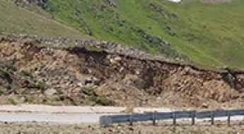
Morkaya Road is one of the most demanding drives in the world
Located in the District of Yusufeli, Artvin Province, in North-East Turkey, the road to Morkaya is one of the most dangerous roads in the world. This road has humbled many egos. It’s not for the sissies.
How to drive the unpaved road to Çalyan Tepe and Lake Çalyan?
Çalyan Tepe is a high mountain pass at an elevation of 2,913m (9,557ft) above sea level, located in Turkey. It’s one of the highest roads of Turkey.
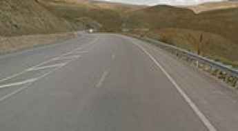
The Mountain Route Through Eastern Turkey: Driving the Scenic D975 Road
The D975 is a high mountain road located in the eastern part of Turkey. It climbs over many mountain passes, reaching a highest elevation of 2,763m (9,064ft) above sea level, and supports heavy traffic.
Köse Dağ
Köse Dağ is a high mountain peak at an elevation of 2.804m (9,199ft) above the sea level, located in Sivas Province of Turkey.
A 4x4 road to Kirklar Mescidi on the summit of Soganli Daglari
Kirklar Mescidi is a high mountain mosque at an elevation of 3.161m (10,370ft) above sea level, located on the boundary of Trabzon and Bayburt provinces, in Turkey. It’s one of the highest roads of the country.
Hüdavendigar Dağı: Driving the high-altitude track of Ağrı
Hüdavendigar Dağı is a high mountain pass at an elevation of 3,111m (10,206ft) above sea level, located in the Ağrı Province of eastern Turkey. Situated near the border with Iran, the route is one of the highest mountain roads of Turkey. It is a primitive, unpaved track that crosses the volcanic ridges of the region, serving as a vital but seasonal link for high-altitude summer pastures.
Fasikan Geçidi
Fasikan Geçidi is a high mountain pass at an elevation of 1.751m (5,744ft) above the sea level located in Karaman Province, in the Mediterranean region of Turkey.
How to drive the paved road to Bülbülen Geçidi
Bülbülen Geçidi is a high mountain pass at an elevation of 2.611m (8,566ft) above sea level, located in Turkey. It’s one of the highest paved roads in the country.
Driving the paved but high-altitude Yaylasuyu Geçidi
Yaylasuyu Geçidi is a high mountain pass reaching an elevation of 2,362 meters (7,749 ft) above sea level in the Erzurum Province of Eastern Anatolia, Turkey. Situated on the strategic D950 State Road, this pass connects the city of Erzurum with Çat. Although the entire 50-kilometer route is asphalted, the combination of thin mountain air and sustained steep gradients turns this drive into a mechanical challenge, especially for heavy transit vehicles and furgonetas that must navigate the extreme weather shifts of the Anatolian highlands.
How to drive the unpaved road to Güldağı Tepe?
Güldağı Tepe is a high mountain pass at an elevation of 2,834m (9,297ft) above sea level, located in the Artvin Province of the Black Sea region in northeastern Turkey. The route is a 21.6 km unpaved corridor that serves as a high-altitude link through the Pontic Mountains. Logistically, this is one of the most demanding tracks in the region, requiring 4WD vehicles with high ground clearance to navigate a surface dominated by sharp, exposed rocks and extreme vertical exposure.
Driving the extreme 4x4 track to Koçbaşı Tepe in Van
Koçbaşı Tepe is a massive mountain peak standing at 3,028 meters above sea level in the Van province of eastern Turkey. This is not just one of the highest mountain roads in Turkey; it is a raw, high-altitude ascent where the concept of a "road" disappears. The track to the summit is a primitive pair of ruts carved into the alpine tundra, offering no room for error and requiring total focus. Driving here means entering a remote mineral world where the wind, the thin air, and the complete lack of infrastructure turn a 6-kilometer climb into a high-stakes mechanical challenge.
Road to Kuskunkıran Geçidi: Driving the 2,245m High Pass in Turkey
Located on the provincial boundary between Bitlis and Van in eastern Turkey, Kuskunkıran Geçidi is a high mountain pass at an elevation of 2,245m (7,365ft) above sea level. This section of the D300 highway was the primary logistical link between the two provinces until the opening of the 2,306m Kuskunkıran Tunnel, which now bypasses the steepest part of the climb.
Gebeli Orman Gözetleme Kulesi: The brutal 4x4 climb in Isparta
Gebeli Orman Gözetleme Kulesi is an extreme high-altitude fire lookout tower at an elevation of 2,175 meters (7,135 ft) above sea level, located in the Isparta Province of Turkey’s Mediterranean region. The road to the summit, known as the Gebeli OGK yolu, is a technical 11.5-kilometer track that scales the jagged peaks of southwestern Turkey. The physical reality of this climb involves managing a raw, rocky surface with 18 sharp hairpin turns where the vertical exposure is total and the mechanical strain on the drivetrain is constant due to an average gradient exceeding 9%.
Pivazok Tepesi: Driving One of Turkey's Highest Gravel Roads (7.08% Avg. Gradient)
Pivazok Tepesi is a demanding high mountain pass situated in the remote Ağrı Province of Turkey. Reaching an elevation of 2,957 meters (9,701 ft) above sea level, this challenging route is notable for its steep, unpaved surface and extreme mountain environment.
Driving the steep and dangerous Kemer Dağı pass in Bayburt
Kemer Dağı is a high mountain pass at an elevation of 2,582 meters (8,471 ft) above sea level, located in the Aydıntepe District of the Bayburt Province, Turkey. Situated in the rugged Pontic Mountains, this pass is a critical and technical link between Kavlatan and Suludere. Although the 27-kilometer route was recently paved, the physical reality of driving here is defined by extreme altitude shifts and an unstable geography where the road is constantly under threat from the surrounding rock faces.
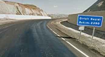
Things to Know Before Driving through Çirisli Geçidi
Çirisli Geçidi is a high mountain pass at an elevation of 2.320m (7,611ft) above sea level, located in Erzurum Province, Turkey.
How to drive the unpaved road to Kara Dağ in Hakkâri
Kara Dağ is a high mountain peak at an elevation of 3,308m (10,853ft) above sea level, located in the Hakkâri province of Turkey. It is one of the highest roads in Turkey.
How to drive the paved road to Palandöken Geçidi in Erzurum?
Palandöken Geçidi is a high mountain pass at an elevation of 2.897m (9,504ft) above sea level, located in the province of Erzurum, in Turkey.
Driving the high altitude volcanic track to Ala Dağlar in Ağrı
Ala Dağlar is a high-altitude gap in the Ağrı Province of eastern Turkey that reaches an elevation of 3,001 meters. This is one of the highest roads in the country, cutting through a raw volcanic landscape where the track is nothing more than a mix of loose ash and jagged basalt rocks. Driving here means pushing your vehicle through a lunar environment where the weather is unpredictable and the ground is constantly shifting. It is a slow, technical grind where any mechanical weakness will leave you stranded miles from the nearest village.
Driving the high altitude Hanlar Geçidi on the D070 road
Hanlar Geçidi is a high mountain pass reaching 2,271 meters in the Kars Province, located in the rugged highlands of northeastern Turkey near the Armenian border. Sitting on the D070 highway, this pass is a vital link between the city of Kars and the town of Digor. While the road is fully asphalted, the high elevation and the exposure to the elements make it a technical drive where the weather can turn from a clear sky to a blinding blizzard in a matter of kilometers, testing both the vehicle's traction and the driver’s nerves.
Çamlıyayla to Delimahmutlu: Driving the Steep 21% Taurus Track in Turkey
The mountain road linking Çamlıyayla and Delimahmutlu is a high-altitude backcountry route running along the provincial boundaries between Mersin and Konya in Turkey. Crossing the rugged core of the Taurus Mountains, the 58-kilometer unpaved track forces four-wheel-drive vehicles to manage tight limestone slopes, severe altitude engine drops, and unprotected vertical drop-offs.
How to drive the unpaved road to Pirreşit Dağı in Van?
Pirreşit Dağı is a high mountain peak at an elevation of 3.086m (10,124ft) above sea level, located in the Muradiye district of Turkey. It’s one of the highest roads of the country.
Alaca Dağ
Alaca Dağ is a high mountain pass at an elevation of 2.814m (9,232ft) above the sea level, located in Artvin Province in the Black Sea region of Turkey.
How to get by car to Devedagi Tepesi?
Devedağı Tepesi is a high mountain pass at an elevation of 2.821m (9,255ft) above sea level, located on the border of Artvin and Erzurum provinces of Turkey.
Is the 4x4 road to Yalın Dağ in Van difficult to drive?
Yalın Dağ is a high mountain pass at an elevation of 2,950m (9,678ft) above sea level, located in the Van province of eastern Turkey. It is one of the highest motorable roads in the country, offering a raw driving experience near the Iranian border. It’s one of the highest roads of the country.
Driving the dangerous cliff road through Çakıt Vadisi
The cliff road through Çakıt Vadisi is an extreme unpaved route situated on the provincial boundary between Adana and Mersin in southern Turkey. The track runs along a narrow shelf cut into the limestone walls of the Taurus Mountains.