What are the most spectacular roads in Canada?
Located in the northern part of North America, Canada -the second-largest country in the world- hosts many challenging drives, with more than 100 roads listed as the most spectacular worldwide. With mountains, lakes, rivers and coasts, the country has roads for every driver.
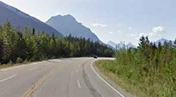
If you’re up for a scenic drive, the Icefields Parkway in the Canadian Rockies is a must do. Located in Alberta province, the road through big mountains, glaciers, and deep blue lakes is one of the most scenic drives in the world. But due to the geography of the country, you can tackle some challenging roads, such Coquihalla Highway, one of the worst roads in winter. In spring, summer, or fall, it's a breeze, but in winter, there are at least 400-500 accidents and plenty of fatalities.
If you’re up for a lifetime adventure, try the Trans-Labrador Highway, one of the world's most epic and remote road trips. Located in the province of Newfoundland and Labrador, most of the road features a well-packed asphalt/gravel surface, but along the route, drivers will experience sharp curves, winding parts, narrow bridges, and steep grades. And a very scenic yet difficult drive is the Bella Coola Road in British Columbia. It’s a 454-kilometer drive known for its steep grades and scenic views through a very diverse landscape.
How to get to the scenic Athabasca Pass Lookout in Alberta?
Located in the Alberta province of Canada, the Athabasca Pass Lookout sits at an elevation of 1.277m (4,189ft) above sea level.