What are the most spectacular roads in Pakistan?
Home to K2, the second highest peak in the world, Pakistan is a very mountainous country, located in the southern part of Asia. The country is a paradise for 4x4 mountain lovers, as it comprises the Himalayas, the Karakorams, and the Hindu Kush mountain ranges.
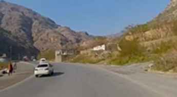
The country covers an area of 881,913 km2 and it’s bordered by India, Afghanistan, Iran, and China. However, due to the situation of the country, traveling there is not advised. If you travel to Pakistan, you should remain cautious and vigilant, including in major cities. There is a high threat of terrorism. The security situation is fragile and unpredictable. Several terrorist groups are present and operate across the country. If you take the risk, the country is home to countless mountain roads as well as a coastline along the Arabian Sea, providing beautiful coastal drives.
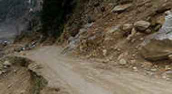
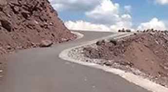
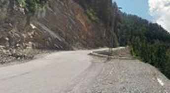
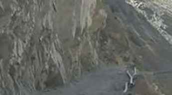
Speaking about roads, when traveling to Pakistan you can’t miss the treacherous Fairy Meadows Road. Located in the Gilgit-Baltistan region, the unpaved road is completely unmaintained, with no guardrails to protect you, and it gets so narrow that near the end, you’ll have to cover the last section by walking or biking. It’s also worth driving to Khunjerab Pass, the highest border crossing in the world, sitting at an elevation of 4,706m (15,439ft) above sea level, on the border with China. Babusar Pass is a mountain pass at 4,179m (13,710ft) above sea level on the boundary between Khyber Pakhtunkhwa and Gilgit-Baltistan provinces. It’s one of the most hairpinned roads in the world. And if you’re brave enough, try the Khaltaro Valley Road. Imagine a narrow gravel road, very steep (up to 15%) with horrendous drops on both sides. Welcome to hell! Only the suicidal, the insane, or the paid-to-do-this should ever drive down.
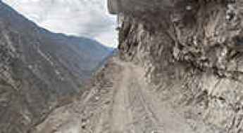
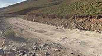
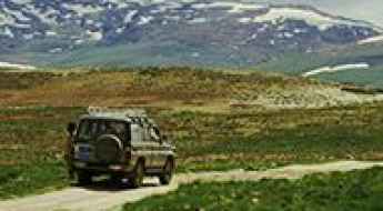
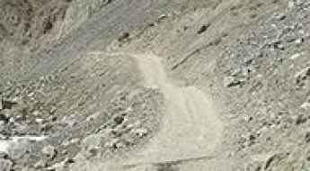
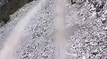
Driving the Treacherous Fairy Meadows Road in Pakistan
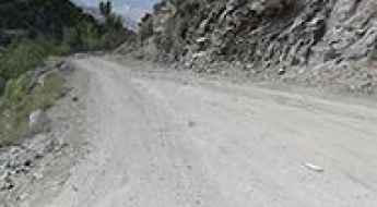
Fairy Meadows Road is a spectacular and perilous high mountain track located in the Gilgit-Baltistan region of Pakistan. The unpaved road is completely unmaintained, with no guardrails to protect you, and it gets so narrow that near the end, you’ll have to cover the last section by walking or biking.
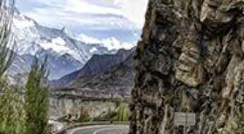
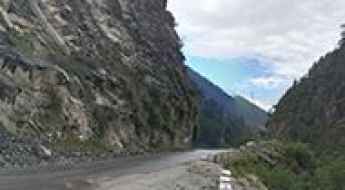
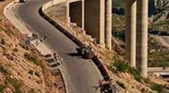
Karakoram Highway is the highest paved international road and Eighth Wonder of the World
The Karakoram Highway (informally known as the KKH) is said to be the highest paved international road in the world, running between Western China and Pakistan. It's the road to paradise for those who love exploring the mountains, offering a once-in-a-lifetime road trip for adventure lovers.
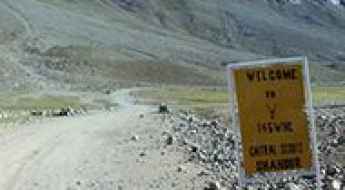
Khunjerab Pass: Conquering the Highest Border-Crossing in the World
Khunjerab Pass is an international high mountain pass at an elevation of 4,706m (15,439ft) above sea level, located on the border of Pakistan and China. It is said to be the highest border-crossing in the world and is the highest point on the Karakoram Highway.
Driving the winding road to the top of Babusar Pass
Babusar Pass is a high mountain pass at an elevation of 4,179m (13,710ft) above sea level located on the boundary between Khyber Pakhtunkhwa and Gilgit-Baltistan provinces of Pakistan. It’s one of the most hairpinned roads in the world.
The Ultimate Guide to Traveling the Neelum Valley Road
Neelum Valley Road is a spectacular and dangerous high mountain road located in Azad Jammu and Kashmir, in the western portion of the larger Kashmir region, in Pakistan, running parallel to Kaghan Valley and the Line of Control (LOC).
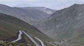
Dare to drive the defiant road from Gilgit to Skardu
Located in Gilgit–Baltistan, in the northern portion of the larger Kashmir region of Pakistan, the road from Gilgit to Skardu is a very challenging drive.
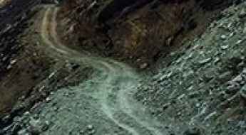
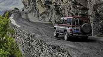
Welcome to hell: Khaltaro Valley Road is a scary drive
Tucked away in the Gilgit district, in the Northern Areas of Pakistan, the Khaltaro Valley Road is one of the scariest roads ever. Imagine a narrow gravel road, very steep (up to 15%) with horrendous drops on both sides. Welcome to hell! Only the suicidal, the insane, or the paid-to-do-this should ever drive down.
Driving the lethal Shimshal Valley Road in Pakistan
Shimshal Valley Road is a terrifying mountain drive located in Pakistan that tests both the skills of drivers and the endurance of their vehicles.
Lowari Pass is the Grand Daddy of the passes
Lowari Pass is a high mountain pass at an elevation of 3,118m (10,230ft) above sea level, located in the Khyber-Pakhtunkhwa region of Pakistan. It’s said to be the Grand Daddy of the passes. It is one of the most famous hairpinned roads in the world.
Fairy Meadows Road is the 2nd deadliest highway in the world
Pakistan’s picturesque Fairy Meadows Road, leading to the base of the Nanga Parbat Mountain has been ranked as the second deadliest highway in an interactive map released recently.
Bolan Pass is a gateway to and from South Asia
Bolan Pass is a high mountain pass at an elevation of 1.793m (5,884ft) above sea level located in Pakistan. The pass has been used as a gateway to and from South Asia.
The road to Paye Lake: some turns are enough to raise your hair
Siri Paye is a high mountain lake at an elevation of 3,025m (9,924ft) above sea level, located in the Khyber-Pakhtunkhwa province of Pakistan.
Driving the terrifying road to Noori Top in Pakistan
Noori Top is a high mountain pass at an elevation of 3,949m (12,956ft) above sea level, located on the boundary between Khyber Pakhtunkhawa Province and Azad Kashmir, in Pakistan.
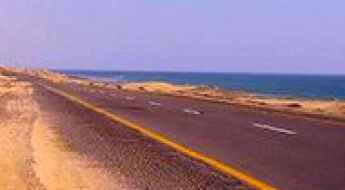
Driving the scenic Makran Coastal Highway
Running along Pakistan's Arabian Sea coastline, the Makran Coastal Highway is one of the most scenic coastal drives in the world.
The paved Khyber Pass is part of the Silk Road
Khyber Pass is a high mountain pass at an elevation of 1,070m (3,510ft) above sea level, located in the Khyber Pakhtunkhwa province of Pakistan. The road through the pass is the main route between Pakistan and Afghanistan.
Pir Chinasi is a frighteningly narrow road in Pakistan
Pir Chinasi is a high mountain peak at an elevation of 2.900m (9,500ft) above sea level, located in the Azad Jammu and Kashmir region of Pakistan.
Road trip guide: Conquering Nathia Gali in Pakistan
Nathia Gali is a mountain resort town at an elevation of 2,450m (8,038ft) above sea level, located in the Abbottabad District of Khyber Pakhtunkhwa, Pakistan.
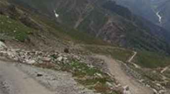
Dare to drive the dangerous Deosai Park Road
Deosai Park Road is a very defiant drive located in the Skardu Gilgit-Baltistan province of Pakistan.
National Highway 15 is a very popular drive among tourists in Pakistan
National Highway 15 (N-15) is a scenic highway located on the boundary between Khyber Pakhtunkhwa and Gilgit-Baltistan provinces of Pakistan.
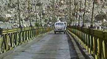
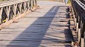
The wooden Alam Bridge is one of the scariest bridges in the world
Located in the Gilgit District of Gilgit-Baltistan region in Pakistan, the Alam Bridge was built with a combination of iron rods and wood over the Gilgit River. It is one of the scariest bridges in the world.
Driving the hairpinned road to Burzil Pass in Pakistan
Burzil Pass is a high mountain pass at an elevation of 4.210m (13,812ft) above sea level, located in the Gilgit-Baltistan territory of Pakistan.
Garhi Dupatta is a spectacular bridge in Pakistan
Located near the small town of Garhi Dupatta, in Muzaffarabad District, Azad Kashmir, Pakistan the Bailey bridge over the Jhelum river is one of the most spectacular bridges in the world.
The unforgettable hairy road to Lalazar in Pakistan
Lalazar is a tourist spot at an elevation of 3,123m (10,246ft) above sea level, located in Mansehra District of Khyber Pakhtunkhwa province of Pakistan. The road to the picturesque area tests the skill and courage of any driver.
Don’t glance down at your phone on the Astore Valley Road
Astore Valley Road is a very challenging drive located in the Gilgit-Baltistan territory of Pakistan.
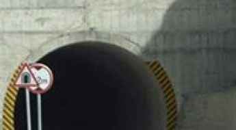
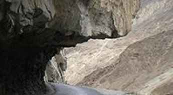
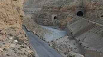
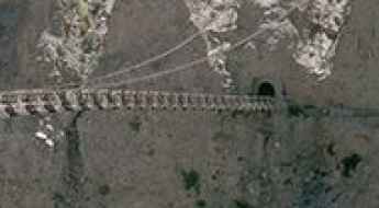
Travelling through the Attabad Lake tunnel
The Attabad Lake Tunnel is a series of five tunnels located near the village of Attabad in the Hunza Valley of Gilgit-Baltistan, Pakistan.
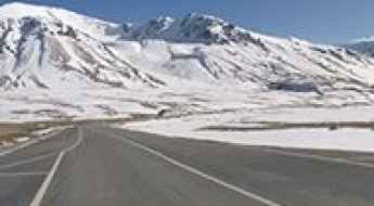
Shandur Pass: driving in 1st and 2nd gear only
Shandur Pass is a high mountain pass at an elevation of 3.728m (12,230ft) above sea level, located on the boundary between Chitral and Ghizer districts of Gilgit Baltistan, in Pakistan. Expect a rough gravel road and driving in 1st and 2nd gear only.
Driving the unpaved road to Lake Saiful Muluk, the Mirror of Heaven in Pakistan
Saif ul Maluk is a clear water lake with a slight green shade, located at an elevation of 3,224 meters (10,578 feet) above sea level in Mansehra District, Khyber Pakhtunkhwa province, Pakistan..
Dare to drive the dangerous road from Bahrain to Kalam
Running along the banks of the Swat River, in the Khyber Pakhtunkhwa province of Pakistan, driving the road from Bahrain to Kalam is not for the faint-hearted.
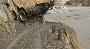
Discovering the unpaved road from Chitral to Parsan is a terrifying adventure on wheels
The road from Chitral to Parsan is one of the most frightening drives in the world. Located in the Parsan Valley of the Khyber Pakhtunkhwa province of Pakistan, the road is a nightmare for travelers. It’s literally blasted out of the side of the mountain, and the smallest error can be fatal.
A memorable road trip to Ali Malik Mar Pass in Pakistan
Ali Malik Mar Pass is a high mountain pass at an elevation of 4.082m (13,392ft) above sea level, located in Skardu Gilgit-Baltistan province of Pakistan.
A Journey on Kalash Valley Road, Pakistan's Most Challenging Drive
Kalash Valley Road is a very defiant road located in the northernmost district of Pakistan, Chitral district, near the Afghanistan border. It’s one of the most challenging roads of the country.
Raakhi Gaaj Project is the Asia’s Second Largest Steel Bridge
Located in the Punjab province of Pakistan, Raakhi Gaaj Project is said to be the Asia’s Second Largest Steel Bridge. It’s one of the most spectacular bridges in the world.
Danyore Suspension Bridge: Crossing the "Bridge between Heaven and Hell"
In the heart of Gilgit-Baltistan, the Danyore Suspension Bridge stands as one of the most extreme examples of mountain engineering in Northern Pakistan. Spanning 510 feet across the Hunza River, this narrow cable-and-plank structure is locally known as "Pul-e-Sirat"—the bridge between heaven and hell. It is a high-consequence crossing that ends abruptly in a 10-meter curved tunnel carved directly into the vertical rock face, creating a transit that is as claustrophobic as it is dizzying.
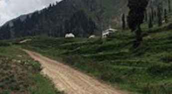
How to Survive on the road to Naltar Lakes
Naltar Lakes is the given name to three lakes – Strangi Lake, Blue Lake, and Bodlok Lake – situated in the Gilgit District of the Gilgit–Baltistan territory of Pakistan. The lakes are inaccessible by vehicle during the winter season.
Badawi Pass is a difficult road for experienced drivers only
Badawi Pass is a high mountain pass at an elevation of 3.523m (11,558ft) above sea level, located in the Khyber Pakhtunkhwa province of Pakistan.
Haramosh Valley Road: Avoid Driving in Rain or After Sunset
Located in the Gilgit district, in the Northern Areas of Pakistan, the Haramosh Valley Road is a narrow gravel road, pretty steep with dangerous drop-offs. Don’t try the drive in rain or after the sunset.