How to drive the high-altitude track to Pico Miranda?
Pico Miranda is a high mountain peak at an elevation of 4,162m (13,654ft) above sea level, located in the Mérida region of Venezuela. Situated within the Sierra de la Culata National Park, it ranks as one of the highest driveable points in the Venezuelan Andes. The route is a technical spur that demands high-altitude experience and a vehicle prepared for sustained steep gradients in thin air.
| Road facts: Pico Miranda | |
|---|---|
| Location | Mérida, Venezuela (Sierra de la Culata) |
| Elevation | 4,162 m (13,654 ft) |
| Length | Approx. 7 km (from La Venta) |
| Surface | Unpaved / Loose rock and mud |
What are the technical conditions of the road to Pico Miranda?
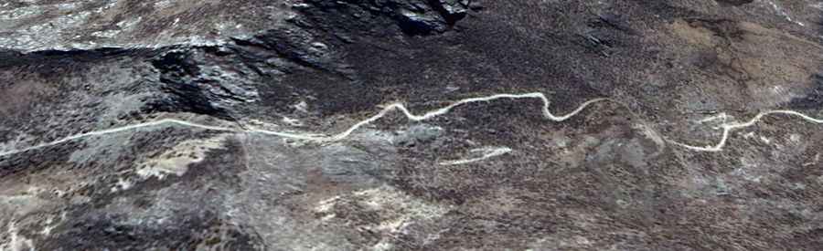
The 7km track starting from La Venta is entirely unpaved and characterized by a "bumpy" and irregular surface. Technically, the road suffers from severe erosion due to the high humidity of the Andean páramo. Logistically, a 4x4 vehicle with high clearance is mandatory. The track consists of loose scree and deep ruts that can easily trap a 2WD vehicle. Due to the lack of official mapping, drivers must rely on visual line selection to avoid soft shoulders that collapse into the steep valley sides. The road is a prime example of the challenges found on the highest roads in Venezuela, where maintenance is non-existent.
How does the altitude affect vehicle performance on Pico Miranda?
At 4,162m, the atmospheric pressure is significantly lower than at sea level. Logistically, this means internal combustion engines will experience a power loss of approximately 30-35%. Technically, the cooling system is also under extreme stress; the lower boiling point of coolant at high altitudes can lead to overheating even in cold ambient temperatures. Drivers should monitor engine temperature gauges closely during the slow, high-torque ascent. Safety protocols recommend using low-range gears (4L) for both the climb and the descent to ensure maximum traction and to prevent brake fade on the steep return toward La Venta.
What is the climate like on the Pico Miranda ascent?
The weather in the Sierra de la Culata is notoriously unpredictable. Technically, you are driving through a high-altitude "tundra tropical" environment. Logistically, visibility can drop to less than 10 meters in seconds due to the "neblina" (thick fog) that rolls up from the lower valleys. Temperatures at the 4,162m summit often hover near freezing, and sudden rain can turn the rocky track into a slippery mud slide. There are no logistical supports, fuel stations, or mechanical workshops beyond La Venta, making self-sufficiency—including carrying extra fuel and recovery gear—a technical necessity for this route.