Driving the paved road to Collado del Condor in the Andes
Collado del Cóndor is a high mountain pass at an elevation of 4.050m (13,287ft) above sea level located in the Merida region, of Venezuela. It's one of the highest roads of the country.
What’s the history of Collado del Cóndor?
At the top of the pass there’s a bronze statue of a real condor, which commemorates when Simon Bolivar and his army of liberation passed the Andes in 1813, during the Admirable Campaign, and there’s a shop where visitors can drink hot chocolate and buy souvenirs and a the small white-and-green chapel.
Is the road to Collado del Cóndor paved?
Set high in the Andes mountain range, the road to the summit is totally paved. It’s called Trans-Andean highway, also known as 7 National/Troncal road. It's the highest point on the road. North to the pass, a paved road climbs up to a weather station, known as Estación Sismologica Redsav Pico El Aguila, at 4.208m (13.805ft) above sea level.
How long is the road to Collado del Cóndor?
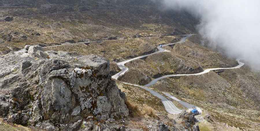
The road to the summit, also known as Pico El Aguila, is 50.6 km (31.44 miles) long, running south-north from Apartaderos to Timotes. With more than 40 hairpin turns and without guardrails, the drive is not easy. Beware that on weekends it's very crowed -so try to arrange your visit on a weekday.
How long does it take to drive the road to Collado del Cóndor?
To drive the road without stopping will take most people between 1.5 and 2 hours.
Is Collado del Cóndor worth the drive?
The drive offers stunning views. The summit is a beautiful viewpoint over the surrounding desert mountains. The landscape is characterized by páramo with the high-altitude shrub frailejón (Espeletia Schultzii) that is endemic to the Andean Mountains of Colombia, Ecuador and Venezuela. From the summit it’s a beautiful switchback drive down all the way to Lake Maracaibo.
Pic: Rogelio Rojas