What are the most spectacular roads in Venezuela?
Located on the northern coast of South America, Venezuela is a dream for drivers. The country hosts a very diverse geography, providing endless roads for everybody.
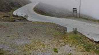
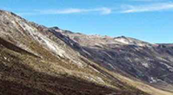
When travelling to the country, you can’t miss driving the paved road to Collado del Condor in the Andes, a mountain pass at 4,050m (13,287ft) above sea level in the Merida region of Venezuela. It's one of the highest roads in Venezuela. Or the Trans-Andean Highway, a real adventure in the heart of the Venezuelan Andes. And if you’re in love with paved roads, don’t forget the drive to Apartaderos, one of the highest towns in Venezuela. Located at 3,505m (11,499ft) above sea level, it’s one of the highest towns accessible by car on Earth.
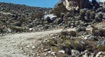
If you prefer unpaved roads, try to tackle the road to Las Pailas peak. At an elevation of 4,579m (15,022ft) above sea level and located in the Sierra de La Culata range, it’s said to be the highest road in the country.
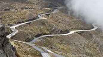
Driving the paved road to Collado del Condor in the Andes
Collado del Cóndor is a high mountain pass at an elevation of 4.050m (13,287ft) above sea level located in the Merida region, of Venezuela. It's one of the highest roads of the country.
A narrow scenic road to the summit of La Cumbre Choroni
La Cumbre Choroni is a high mountain pass at an elevation of 1.611m (5,285ft) above sea level, located in the state of Aragua, in Venezuela.

Crossing the defiant Cuyuni River bridge
Located in eastern Venezuela, the Cuyuni River bridge is said to be designed by the famous Gustave Eiffel. It’s one of the most spectacular bridges in the world.
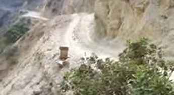
Driving the Dangerous Unpaved Road to Los Nevados in Merida
Los Nevados is a beautiful mountain village at an elevation of 2,711m (8,894ft) above sea level, located in the State of Mérida, in Venezuela.
How to get by car to Apartaderos, one of the highest towns of Venezuela
Located in Mérida State, in Venezuela, Apartaderos is one of the highest towns in the country, at an elevation of 3,505 m (11,499 ft) above sea level. It’s also one of the highest towns accessible by car on Earth.
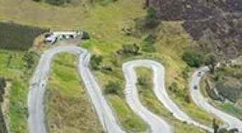
Trans-Andean Highway, a drive you'll never forget
Carretera Trasandina is a true adventure in the heart of the Venezuelan Andes. It’s one of the most delightful drives in South America.
How to drive the 20% ramps to Cerro Ávila in Caracas?
Cerro Ávila is a high mountain peak at an elevation of 2.156m (7,073ft) above sea level, located in the Capital District of Venezuela. The average gradient is 14.61%.
How to drive the haunted paved road to Páramo La Negra?
Páramo La Negra is a high mountain paramo, at an elevation of 3.065m (10,055ft) above sea level, located in Venezuela.
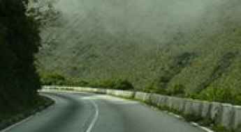
A delightful yet challenging road to Páramo el Zumbador
Páramo el Zumbador is a picturesque hamlet at an elevation of 2.571m (8,435ft) above the sea level, located in the Venezuelan state of Táchira.
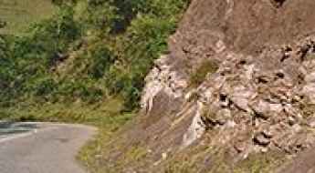
Alto de Mifafi: this road is not for timid drivers
Alto de Mifafi is a high mountain pass at an elevation of 4.414m (14,481ft) above the sea level, located in Sierra de La Culata range, in Mérida State, Venezuela. It's one of the highest roads of the country.
How to drive the high-altitude track to Pico Miranda?
Pico Miranda is a high mountain peak at an elevation of 4,162m (13,654ft) above sea level, located in the Mérida region of Venezuela. Situated within the Sierra de la Culata National Park, it ranks as one of the highest driveable points in the Venezuelan Andes. The route is a technical spur that demands high-altitude experience and a vehicle prepared for sustained steep gradients in thin air.
Road trip guide: Conquering Las Pailas peak
Pico Las Pailas is a high mountain peak at an elevation of 4.579m (15,022ft) above the sea level, located in Sierra de La Culata range, in Mérida State, Venezuela. It’s said to be the highest road in the country.
Highway 10: The Transatlantic Cocaine Corridor Bridging South America and Africa
The 10th Parallel marine and aerial routes, known historically for facilitating trade between South America and West Africa, have taken on a new and sinister role in modern times. These routes, spanning a distance of approximately 2,500 kilometers between Venezuela and the western coast of Africa, have earned the ominous moniker "Highway 10" among law enforcement due to their use by Latin American drug cartels for shipping vast quantities of cocaine to the ever-expanding European market.
What are the highest roads in Venezuela?
Situated on the northern coast of South America, Venezuela takes the shape of an inverted triangle. It shares its borders with the Caribbean Sea and the Atlantic Ocean to the north, Guyana to the east, Brazil to the south, and Colombia to the west. This former Spanish colony is slightly smaller than twice the size of California.
An awe-inspiring road to Mirador El Domo de La Culata
Mirador El Domo de La Culata is a natural viewpoint at an elevation of 4.291m (1,4078ft) above the sea level, located in Mérida State, Venezuela. It's one of the highest roads of the country.
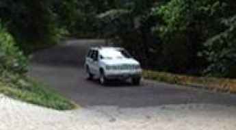
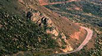
Driving the Maracay-Ocumare de la Costa Road: A Scenic Route to Venezuela's Caribbean Coast
The Maracay-Ocumare de la Costa road (also known as local highway 7) spans 51.6 km (32 miles) and is the only land route connecting Maracay to the Ocumare de la Costa de Oro municipality. This road links Venezuela's central region with Henri Pittier National Park and the Caribbean Sea. Characterized by numerous sharp curves, it travels through the tropical jungle of Henri Pittier National Park, running from Maracay, the capital city of Aragua state, to the small coastal town of Ocumare de la Costa.