How dangerous is the Carretera Cincha–Huanca to Abra de Rumualdo?
Abra de Rumualdo is a high mountain pass reaching an elevation of 3,434 meters (11,266 ft) above sea level in the Caylloma Province of Peru. The journey over the summit runs along the Carretera Cincha–Huanca, a remote route where the road surface disintegrates completely as you climb higher, turning from a basic road into a narrow mountain ledge.
| Road facts: Abra de Rumualdo | |
|---|---|
| Location | Caylloma Province, Peru |
| Elevation | 3,434 m (11,266 ft) |
| Length | 63 km (39 miles) from Taya to Cincha |
| Surface | Asphalt to unpaved gravel and dirt track |
| Main Hazards | Over 200 turns, landslides, and deep drop-offs |
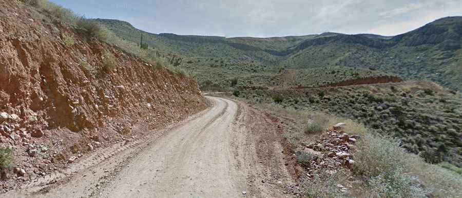
Is the Carretera Cincha–Huanca paved or unpaved?
The 63-kilometer mountain route is a mix of broken surfaces. It starts with a brief section of smooth asphalt near Cincha, but as the elevation rises, the lanes narrow significantly into a single unpaved track. The upper kilometers turn into a rough gravel path littered with loose stones. The track is carved straight into the rock face of the mountain, offering zero steel guardrails or stone walls to protect tires from the steep cliff drops into the canyon below.
How many hairpin turns are on the road to Abra de Rumualdo?
The drive forces you through more than 200 turns, including dozens of tight, blind hairpins. These switchbacks are exceptionally narrow, forcing drivers to sound their horn constantly on the single-lane curves to warn oncoming vehicles. Driving these bends is demanding; the loose gravel offers very little tire grip, causing the rear wheels to slide toward the cliff edges if you go too fast. The constant exposure to deep drops makes it tough for anyone prone to vertigo.
Why are landslides a major danger at 3,434m?
The slopes in the Caylloma region are highly unstable. Minor earth tremors or a brief mountain rain shower can trigger rockfalls that dump boulders directly onto the driving lane. Because the gravel track is so narrow, even a small slide can block the path completely, leaving drivers trapped for days. There are no towns, fuel stations, or cell phone towers up here, making it impossible to call for mechanical assistance if you get stuck behind a rockfall.
Can you drive through the pass during bad weather?
Attempting the 63 km crossing during rain or snow is extremely risky. Sudden snowstorms and blinding blizzards frequently hit the 3,434-meter summit while the lower valleys are completely clear. During these storms, driving visibility drops to zero, and the dirt track turns into a thick, slick slurry of mud and slush. The upper unpaved ramps become impassable for normal cars, and even high-clearance 4x4 vehicles will slide sideways on the steep, unprotected ledges. If clouds cover the peaks near Taya or Cincha, turn around and wait.