The Mysterious Plane in the Andes: A Google Earth Mystery
Google Earth often displays unusual sights during virtual exploration. In the Andes of Peru, the silhouette of a large aircraft appears in a remote high-altitude location, creating interest among virtual travelers.
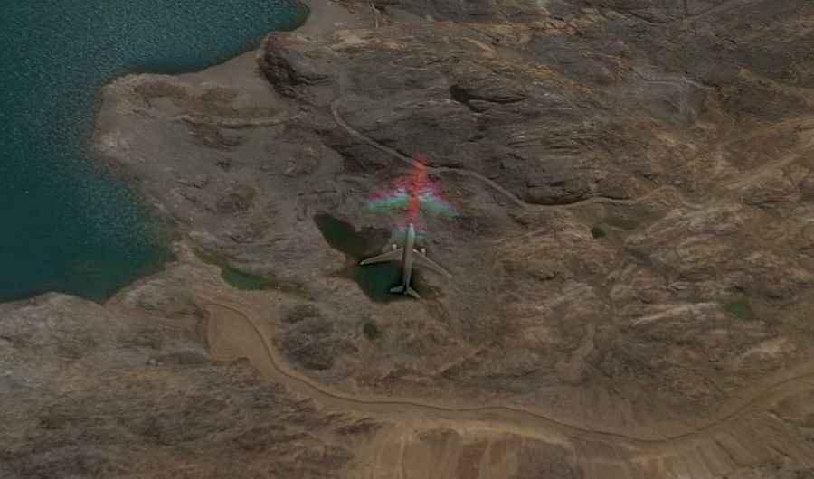
Where is the mysterious plane in the Andes?
The plane is located in Lauricocha Province, within the Huánuco Region of central Peru. The coordinates place the site in a desolate area of the Andes, situated between high mountain peaks and near the Laguna Ninococha.
🔍 Google Earth Mystery: Andes Plane
| Max Elevation | 5,016m (16,456ft) |
| Location | Lauricocha, Peru |
| Destination | Laguna Ninococha |
| Site Type | High-altitude Mine Track |
Is there a road to the mysterious plane in the Andes?
A gravel minor road leads towards the area where the plane is visible. This is a private mine track that serves high-altitude mining operations in the region. It is one of the highest roads in the country, climbing up to an elevation of 5.016m (16,456ft) above sea level before ending at Laguna Ninococha.
Is the mysterious plane in the Andes a real crash site?
The image visible on Google Earth is likely a motion blur artifact or a satellite capture of a commercial aircraft in mid-flight. The transparency and "ghostly" appearance suggest it was flying thousands of feet above the ground when the satellite image was taken, rather than being a parked or crashed airplane on a mountain parking lot.
What are the driving conditions to Laguna Ninococha?
The road to the lake and the "plane" site is an unpaved, high-altitude mine track. Due to the elevation exceeding 5,000 meters, oxygen levels are low and the weather is unpredictable. The track is steep and intended for mining vehicles, requiring a high-clearance 4x4. Heavy snow and freezing temperatures make the road impassable for most of the year.