Don Mario and Punta Pumacocha: The grueling 42km 4x4 crossing in Peru
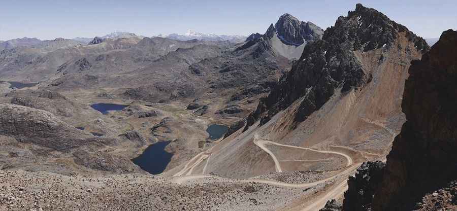
Crossing the rugged border between the Lima and Junin regions in central Peru is a task for the most experienced off-roaders. This 42km high-altitude traverse takes you over two massive passes: Don Mario Pass and Punta Pumacocha. Reaching nearly 5,000 meters, this is a remote mining corridor where the thin air and extreme gradients create one of the most demanding driving environments in the Andes.
| Road facts: Don Mario & Punta Pumacocha | |
|---|---|
| Route | Huancapallca to JU-110 Road |
| Length | 42.1 km (26.1 miles) |
| Highest Point | 4,990 m (16,371 ft) |
| Max Gradient | 10.5% (Final section) |
| Vehicle Required | Strictly 4x4 High Clearance |
Where does the road to Don Mario and Punta Pumacocha start and end?
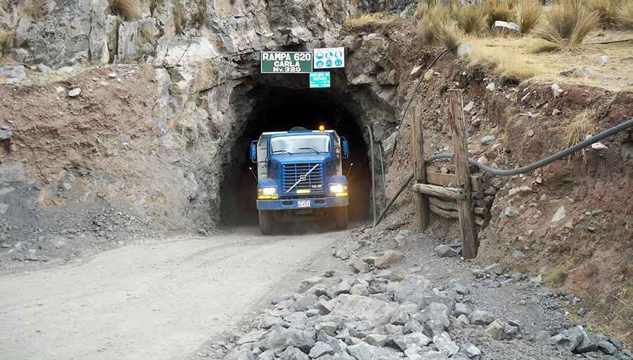
The road spans 42.1 km (26.15 miles), running in a west-east direction from Huancapallca in the Laraos District (Yauyos) to the JU-110 Road in the Junin region. This high-mountain track serves as a lifeline for local mining operations, particularly the Don Mario mine. The geography is dominated by the typical stark beauty of the Peruvian Altiplano: jagged peaks, desolate plateaus, and deep mineral-rich valleys that are as treacherous as they are spectacular.
How challenging is the drive to Don Mario Pass?
The first major obstacle is Paso Don Mario, sitting at 4,739m (15,547ft). Starting from the mine area, the road is totally unpaved and climbs steeply on a very difficult surface. This section is known for being muddy and slippery, especially when wet, making traction a constant struggle. Once you clear the immediate vicinity of the mine, the road reaches a high plateau where the climb becomes gentler for a few kilometers. However, the notorious lack of oxygen at this altitude will already be testing your vehicle's engine combustion and your own physical endurance.
Pic: http://agminsacsilver.blogspot.com/2012/09/mina-don-mario.html
What makes the ascent to Punta Pumacocha extreme?
After crossing the Don Mario plateau, the route reaches its most brutal phase: the climb to Punta Pumacocha at 4,990m (16,371ft). The final few kilometers of this pass are nothing short of extreme. The road is gravel and incredibly steep, featuring an average gradient of 10.5% in the last section. At nearly 5,000 meters, this incline is "simply terrible" for any vehicle. The thin air means your engine will be gasping for breath, and low-range gearing is a must to keep moving. If you are scared of heights, the vertical drops and narrow track will be a major psychological test.
Is the road over these passes open year-round?
While the mining industry tries to keep the route active, the weather at these elevations is "harsh and highly unpredictable." Even a single rainfall can turn the track into a challenging mud trap. Avalanches, heavy snowfalls, and landslides are common and can block sections of the road without warning. During the winter, frequent patches of ice make the 10.5% slopes extremely dangerous. High-altitude sickness (soroche) is a serious risk for anyone not properly acclimatized, as the summit has significantly less oxygen than sea level. Proper preparation—including extra fuel, oxygen, and emergency thermal gear—is essential before leaving Huancapallca behind.
Pic: http://www.portlandtopenguins.com/journal/2017/7/17/peru-iii