Road 34H: Conquering Abra Sandia and Laguna Saytococha in Peru
Deep in the Sandia Province of the Puno Region, Road 34H stands as one of the most formidable and dizzying routes in the Peruvian Andes. Stretching for 61 km (38 miles) from Quiscupunco to the town of Sandia, this high-mountain corridor crosses the legendary Abra Sandia pass and skirts the shores of Laguna Saytococha, offering a journey that tests the nerves of even the most seasoned expedition drivers.
| Road facts: Abra Sandia & Road 34H | |
|---|---|
| Route | Quiscupunco to Sandia (Puno) |
| Abra Sandia Elevation | 4,495 m (14,747 ft) |
| Laguna Saytococha Elevation | 4,459 m (14,629 ft) |
| Length | 61 km (38 miles) |
| Surface | Partial Asphalt / Loose Gravel |
Where does Road 34H lead?
The road runs in a south-north direction, plunging from the high Altiplano into the deep, humid valleys of the Amazon basin. The most critical section occurs between the summit of Abra Sandia (also known as Abra Apacheta) at 4,495m and the high-altitude Laguna Saytococha, which sits just below the pass at 4,459m. This is a frontier zone near the Bolivian border, where the geography is dominated by sheer verticality, narrow canyons, and rivers that frequently wash out the roadbed.
Is the road to Abra Sandia paved?
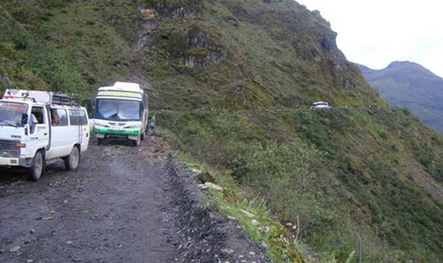
While large sections of Road 34H are asphalted, the surface is often deceptive. The pavement is narrow and worn, snaking through a desolate, treeless landscape where the mountainside seems to crumble onto the track. Frequent floods, avalanches, and landslides mean that many parts are reduced to raw gravel and mud without warning. The road is extremely narrow, in many places scarcely wide enough for two vehicles to pass. If you encounter an oncoming truck on a blind bend, one driver may have to reverse for several kilometers along a winding precipice to find a turnout wide enough to pass. This is a route where high-clearance vehicles are a must, and driving in the wet or dark is a genuine nightmare.
What are the main hazards on the road to Sandia?
The primary danger on Road 34H is the extreme exposure. The road cuts a lonely path through the high Puna, with the pavement often running right along the edge of massive slopes unprotected by guardrails. Looking over the shoulder, there is nothing but a steep drop into the valleys thousands of feet below. Additionally, the region is prone to heavy mist and sudden low visibility, making it easy to lose track of the road's edge. The sheer number of hairpin turns is enough to make any passenger dizzy, and the rapid descent puts a massive strain on a vehicle's braking system.
How to prepare for the altitude and terrain?
At nearly 4,500 meters, the lack of oxygen is a serious factor. It is not uncommon for drivers and passengers to experience altitude sickness (soroche), including nausea and dizziness. It is advisable not to "stuff your belly" before the climb, as the circuitous nature of the road can easily trigger vomiting. Beyond physical health, your mechanical skills must be sharp. You must be confident in your ability to reverse on narrow, crumbling shoulders and manage low gears on steep descents. Help is non-existent in this part of Puno, and any mechanical failure or driving error could result in a free fall into the valleys below. Always carry emergency supplies, extra fuel, and ensure your tires are suited for both wet asphalt and jagged gravel.