How to drive the unpaved AN-844 to Laguna Aguascocha?
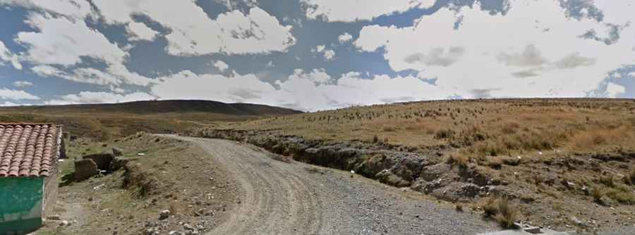
Laguna Aguascocha is a high-altitude Andean lagoon situated at an elevation of 4,370m (14,337ft) above sea level in the Cordillera Blanca of northwestern central Peru. Located within the Huascarán National Park, the access route is via the AN-844 (also referenced as AN-1295 in sections), a 18.7 km unpaved corridor. This road serves as a vital logistical link between the paved Highway 3-N and the Mina Tuco mining site, crossing extreme terrain and passing secondary water bodies such as Laguna Yanacocha.
| Road facts: Laguna Aguascocha (AN-844) | |
|---|---|
| Location | Ancash, Peru (Huascarán National Park) |
| Elevation | 4,370 m (14,337 ft) |
| Length | 18.7 km (11.6 miles) |
| Surface | Unpaved / Loose Gravel |
| Route | Highway 3-N to Mina Tuco |
What are the technical driving challenges on the AN-844 to Laguna Aguascocha?
The 18.7 km transit to Laguna Aguascocha is technically demanding due to the sustained high-altitude environment and the nature of the unpaved substrate. Logistically, the road is a typical Andean "puna" track, characterized by loose gravel and fine dust that significantly reduces traction during the dry season. Technically, a 4x4 vehicle is mandatory to manage the steep gradients and the washboard surfaces (calamina) caused by heavy mining machinery. Drivers must account for a nearly 40% reduction in engine oxygen intake at 4,370m, requiring precise gear management to maintain torque without overheating the cooling system.
How does mining traffic affect the logistics of the Laguna Aguascocha road?
The AN-844 is a dual-purpose route, serving both the Huascarán National Park and the logistical needs of Mina Tuco. Technically, this results in a high frequency of heavy multi-axle trucks that dominate the center of the narrow track. Logistically, the presence of these vehicles creates deep ruts and pushes loose rocks to the shoulders. Drivers must follow a strict defensive driving protocol, prioritizing the uphill-moving heavy vehicles and maintaining a safe distance to avoid the thick dust plumes that can reduce visibility to zero. The track passes near Laguna Yanacocha, where the roadbed is particularly narrow and lacks any form of lateral stabilization.
What are the seasonal hazards in the Cordillera Blanca for the AN-844?
At 4,370 meters, the weather conditions around Laguna Aguascocha are volatile. Logistically, the road can become impassable during the Andean rainy season (December to March) as the unpaved surface turns into deep, unmanaged mud. Technically, the lack of engineered drainage systems on the AN-844 leads to localized washouts and landslides. During the dry season, the primary technical hazard is the "soroche" (altitude sickness) affecting the driver's reaction time. It is a mandatory logistical protocol to carry emergency oxygen, a full-size spare tire, and extra fuel, as there are zero mechanical or supply services between Highway 3-N and the mining terminus.
What are the safety protocols for the high-altitude transit to Mina Tuco?
Navigating the 18.7 km stretch to Mina Tuco requires an experienced operator familiar with high-altitude off-pavement logistics. Technically, the descent from the 4,370m plateau towards the paved 3-N requires a disciplined engine braking protocol to prevent brake fluid boiling on the sustained inclines. Logistically, the area is highly isolated; any mechanical failure at Laguna Aguascocha requires a complex recovery operation from Huaraz or Recuay. Drivers should monitor the weather for sudden snowfalls, which are common even in summer, and ensure that the vehicle's battery and electrical systems are verified, as cold-start failures are frequent at these elevations.