Road to the Junín Lakes: Driving to Alcacocha, Tarusmachay, and Oshgomachay
Located in the heart of the Central Andes of Peru, the journey through the glacial lakes of the Junín region is a high-altitude experience that tests both driver and machine. This remote track connects three stunning Andean mirrors: Laguna Alcacocha, Laguna Tarusmachay, and Laguna Oshgomachay, offering a unique traverse through the desolate beauty of the Meseta de Bombón.
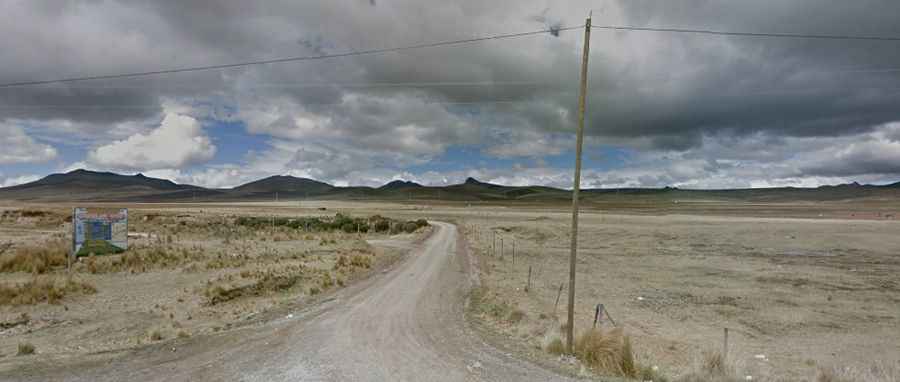
The route is a classic high-mountain "trocha" (gravel road). As seen in recent satellite and street imagery, the track is a well-defined but unpaved ribbon of white gravel that cuts through a vast, treeless plateau. The landscape is dominated by ichu (high-altitude grass) and distant peaks, where the lack of obstacles means the road is completely exposed to the fierce Andean winds and sudden weather shifts.
| Road facts: Junín Lakes Route | |
|---|---|
| Location | North of Junín (Town), Junín Region, Peru |
| Starting Point | Paved 3N Road |
| Length | 14.9 km (9.2 miles) |
| Elevation Gain | 426 m |
| Average Gradient | 2.85% |
| Max Elevation | 4,443 m (Laguna Tarusmachay) |
How long is the road to the Junín Lakes?
The adventure begins just north of the town of Junín, where you leave the safety of the paved 3N Road. From this junction, the gravel road stretches for 14.9 km until it reaches the final lake. While the average gradient of 2.85% might seem manageable on paper, the true challenge lies in the altitude and the cumulative elevation gain of 426 meters in such a thin atmosphere.
The road follows a logical sequence through the mountains. The first body of water you will encounter is Laguna Alcacocha (4,366m). Continuing the climb, the road reaches the highest point of the circuit at Laguna Tarusmachay (4,443m), before finally descending slightly or leveling out to end at Laguna Oshgomachay (4,430m). The entire drive is a slow-burn ascent where the engine's power loss becomes noticeable as you cross the 4,000-meter mark.
What are the driving conditions like in Junín?
The surface is primarily loose gravel and compacted earth. Under dry conditions, the road is straightforward but dusty. However, do not let the relatively flat appearance of the plateau fool you; this is extreme high-altitude driving. Oxygen is in short supply, and most drivers will feel the effects of altitude sickness (soroche) if they haven't acclimated properly in Junín or nearby towns.
Safety is a major concern during the rainy season (November to April). Heavy snowfalls and sudden landslides can turn this transit into a trap. There are no services, no gas stations, and very little traffic on this specific branch. It is highly recommended to use a 4x4 vehicle with good tires, as the gravel can become slippery when wet, and the steep sections require consistent traction to avoid spinning out.
Practical tips for the route
Before leaving the 3N highway, ensure your vehicle is in top mechanical condition. Check your tire pressure and cooling system, as the thin air forces engines to work harder. The "notorious lack of oxygen" at these heights affects your reflexes and decision-making; if you feel a headache or dizziness, it is best to stop or descend immediately. This route is an incredible way to see the "real" Peruvian puna, far from the tourist crowds, where the only companions are likely to be herds of alpacas and the silent, cold waters of the lagoons.