HU-110: Driving the high-altitude lake route in the Peruvian Andes
The HU-110 is a remote high mountain road located in the heart of the Peruvian Andes. This unpaved route is famous for its dramatic scenery, connecting the town of Antacolpa with the border of the Lima region while passing through a spectacular chain of glacial lakes at extreme altitudes.
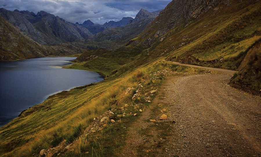
The road is 42.7 km (26.5 miles) long and runs north-south through a desolate but impressive landscape. The surface is entirely unpaved, consisting of dirt and gravel that can become very difficult to navigate during the rainy season. Due to the nature of the terrain, a high-clearance vehicle is highly recommended for this journey.
| Road facts: HU-110 (Antacolpa to Lima Border) | |
|---|---|
| Length | 42.7 km (26.5 miles) |
| Max Elevation | 4,685m (15,370ft) |
| Surface | Totally Unpaved / Dirt |
| Location | Huánuco to Lima border (Peru) |
How is the drive on the HU-110 road?
Starting from Antacolpa, the HU-110 climbs steadily into the high sierra. The road is notoriously narrow, often making it impossible for two vehicles to pass each other at the same time. Drivers must be prepared for steep sections and sharp turns without guardrails. Because it reaches elevations near 4,700 meters, altitude sickness and reduced engine performance are significant factors to consider before starting the drive.
What lakes can you visit along the HU-110?
The highlight of the HU-110 is the series of high-altitude lagoons it passes. Traveling from north to south, these are the main lakes visible from the road:
- Laguna Lauricocha: 4,041m (13,257ft)
- Laguna Taulicocha: 3,966m (13,011ft)
- Lagunas Anaspampa: 3,961m (12,995ft)
- Laguna Patarqucha: 4,130m (13,549ft)
- Laguna Chuspi: 4,201m (13,782ft)
- Laguna Tinquicocha: 4,365m (14,320ft)
- Laguna Caballococha: 4,669m (15,318ft)
- Laguna Puywanqucha: 4,685m (15,370ft)
Each of these lakes is situated in a raw, glacial environment where the road often skirts the water's edge. The highest point of this lake chain is reached near Laguna Puywanqucha, just before the road hits the border of the Lima region.
What are the main hazards on the HU-110 in Peru?
The primary hazards are the extreme altitude and unpredictable weather. Heavy rain, snow, or thick fog can occur at any time, turning the dirt surface into mud. There are no services, fuel stations, or emergency facilities along the 42.7 km stretch. It is essential to be fully self-sufficient and to check local conditions, as the road may become impassable after major storms.
Pic&more info: https://www.brianlucido.com/bikepacking-peru-yungay-to-oyon-via-coordillera-huayhuash/