Laguna Pallarcocha: Driving the remote AR-107 to 4,740m in Peru
Laguna Pallarcocha (also known as Laguna de Payarcocha) is a high-altitude lake at elevation of 4,740m (15,550ft) above sea level, hidden in the Condesuyos Province of the Arequipa Region. Situated in the southern Peruvian Andes, the journey to this remote body of water is a grueling test of endurance, crossing a barren and windswept landscape.
| Road facts: Laguna Pallarcocha | |
|---|---|
| Location | Arequipa Region, Peru (Condesuyos Province) |
| Elevation | 4,740 m (15,550 ft) |
| Road Number | AR-107 / AR-105 |
| Length | 52 km (32.3 miles) |
| Vehicle Required | 4x4 High Clearance Only |
Where is the road to Laguna Pallarcocha?
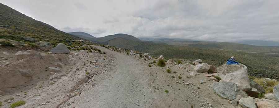
The road spans 52 km (32.3 miles), running in a north-south direction from Arma to Pampacolca. This high-mountain drive, designated as AR-107 and AR-105, cuts through the massive slopes of the Cordillera Ampato. It is dominated by volcanic rocks, sparse puna vegetation, and vast, desolate plateaus. It is a vital but primitive link for the small communities of the Arequipa highlands, far removed from any major urban centers.
Is the road to Laguna Pallarcocha unpaved?
The road is entirely gravel and dirt, carved directly into the mountain soil. It is a primitive track that shows clear signs of erosion and "washboards" due to the extreme climate. Because of the loose surface and the steep sections found along the route, 4x4 vehicles with high clearance are strictly required. Attempting this road in a standard car is a guaranteed way to get stranded. The track follows the natural contours of the ridges, and drivers must pick their lines carefully to avoid the larger stones and deep ruts that form after the rainy season.
What are the weather hazards at Laguna Pallarcocha?
At an elevation of 4,740 meters, the weather is the ultimate judge of whether the road is passable. Do not travel this road in severe weather conditions, as sudden snowfalls or heavy rain can turn the gravel into an impassable muddy slide in minutes. High winds are a permanent feature of this altitude, often causing dust storms that reduce visibility to zero. During the winter months, the road is frequently blocked by snowdrifts, and temperatures can plummet well below -15°C. Altitude sickness (soroche) is also a major factor; at over 15,000 feet, your concentration will lapse and your vehicle's engine will struggle significantly with the lack of oxygen.
Why is the drive to the lake challenging?
The challenge of the AR-107 is its isolation and sustained high altitude. For 52 kilometers, you are exposed to the elements with no services, no cell coverage, and very little traffic. The road requires constant focus to navigate the narrow bends and the bumpy surface. Reaching the lake itself is a silent experience, as the water reflects the barren volcanic peaks of the Arequipa region. Just remember that what goes in must come out: ensure you have enough fuel for the return trip and carry emergency oxygen and thermal gear, as the weather at Pallarcocha can change from bright sun to a technical blizzard without warning.