Is the road to Punta Caudalosa Chica in Peru difficult?
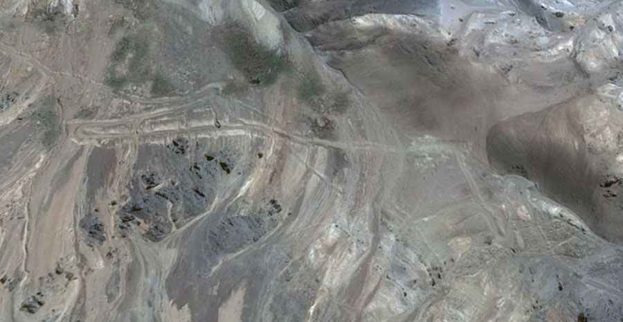
Punta Caudalosa Chica is a high-altitude mountain pass located in the Huancavelica region of Peru. Situated in the Angaraes province, this unpaved mining track climbs through the Andes range to reach a maximum elevation of 4,990 meters (16,371 ft) above sea level.
| Road facts: Punta Caudalosa Chica | |
|---|---|
| Location | Huancavelica (Peru) |
| Elevation | 4,990 m (16,371 ft) |
| Surface | Unpaved (Gravel, dirt, loose rock) |
| Length | 12.1 km (7.5 miles) |
| Hairpins | 13 sharp turns |
How long is the road to the summit of Punta Caudalosa Chica?
The unpaved climb covers a distance of 12.1 kilometers (7.5 miles) starting from the mining settlement of Caudalosa Chica. The route involves a vertical elevation gain of 532 meters with an average gradient of 4.39%. The ascent requires driving through 13 sharp hairpin turns where the dirt track narrows significantly alongside unprotected mountain drop-offs.
What is the road surface like on the road to the summit of Punta Caudalosa Chica?
The track surface consists of a variable mix of loose volcanic gravel, crushed rock, and fine mountain silt. Rain turns the dirt floor into a slippery mud layer that cuts tire traction on the switchbacks. The roadbed is exposed to landslides and rockfalls from the upper slopes, leaving stone debris on the lanes and causing partial washouts that require high ground clearance to avoid hitting the vehicle chassis.
How does the 4,990-meter elevation affect vehicles?
At an altitude of nearly 5,000 meters above sea level, low atmospheric pressure reduces internal combustion engine power by approximately 50%. The steep segments and hairpins force drivers to stay in low gears to maintain engine torque against the incline. This continuous high-rpm operation in thin air increases the vehicle's fuel consumption rate throughout the 12.1-kilometer mountain ascent.
What are the main hazards in this Peruvian mining area?
The high-altitude track faces sudden weather changes, including high-elevation snowfalls that cover the driving ruts and erase the path outline. The pass is located in an isolated mining zone far to the east of the main road connecting Santa Inés and Huancavelica, completely devoid of roadside services, mechanical repair workshops, or cellular mobile coverage.