Jatunchacua: Driving the high Paso Retrochero in the Peruvian Andes
Located on the high-altitude boundary between the Lima and Pasco regions in Peru, the Jatunchacua Pass (locally known as Paso Jatunchacua) is a formidable mountain crossing. Reaching a staggering elevation of 4,833m (15,856ft) above sea level, it stands as one of the highest driveable points in the area, situated just south of the imposing Nevado Retrochero.
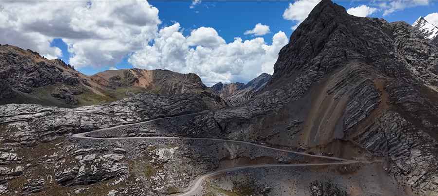
The pass is often referred to in maps as Paso Retrochero, likely due to its proximity to the nearby peak. However, local road signage clearly identifies the spot as Jatunchacua. The route is part of the Cordillera Negra, a stretch of mountains south of the Huascarán National Park known for its desolate beauty, extreme weather, and unpredictable terrain. As seen in the aerial footage, the track is a masterclass in Andean engineering, clinging to the side of jagged, mineral-rich slopes.
| Road facts: Jatunchacua (Paso Retrochero) | |
|---|---|
| Location | Boundary of Lima & Pasco, Peru |
| Elevation | 4,833 m (15,856 ft) |
| Length | 26 km (16.1 miles) |
| Route | Pampahuay to Bañadería |
| Max Gradient | 14% |
| Surface | Unpaved (4x4 required) |
How long is the road through Jatunchacua Pass?
The route through Jatunchacua Pass stretches for 26 km (16.1 miles), running north-south from Pampahuay to Bañadería. It is a slow, technical drive where the average speed is dictated by the rough surface and the notorious lack of oxygen at nearly 5,000 meters. The journey provides stunning views of high-altitude mountain lagoons, which reflect the dramatic slate and rock formations of this "unknown" part of the Andes.
The road is totally unpaved and consists of loose scree and compacted earth. Due to its isolation and the technical nature of the climb, a 4x4 vehicle with a low-range gearbox is mandatory. This is not a place for stock vehicles or inexperienced drivers, as the weather can shift from intense sun to a blinding snowstorm in a matter of minutes, turning the gravel track into a slippery hazard.
How challenging is the climb to Jatunchacua (Paso Retrochero)?
The climb to Jatunchacua is exceptionally steep, featuring ramps with a maximum gradient of 14%. The most technical section is found near the summit, where the road negotiates 10 tight hairpin turns carved into the steep mountainside. These switchbacks require precise maneuvering, as the drops are significant and there are no safety barriers or guardrails along the edge.
The confusion regarding the name adds to the mystery of the place. While most maps label it as Paso Retrochero, travelers will find the green official sign identifying it as Jatunchacua. Regardless of the name, the challenge remains the same: a grueling ascent through the thin air of the Cordillera Negra. High-altitude sickness (soroche) is a real risk for all occupants, and the extreme elevation puts a massive strain on the vehicle's cooling system and engine power. Preparation, extra fuel, and respect for the mountain's traditions are essential for anyone attempting to conquer this Andean giant.
Road suggested by: Hugh Wilson
Pic&video: SLOW ROAMERS