Road to Laguna Yanco: 100 Hairpin Turns in the Ancash Region
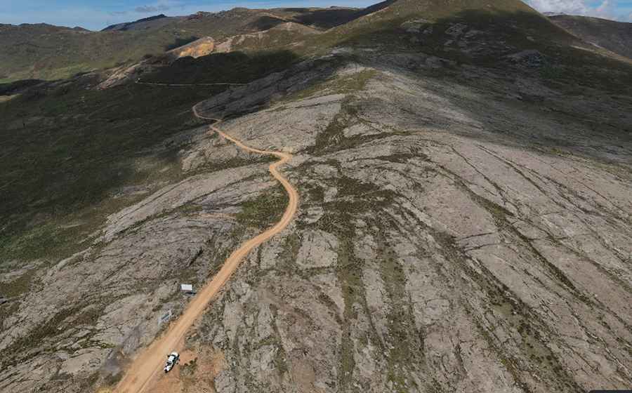
Located in the Aija Province of the Ancash Region in Peru, the road to Laguna Yanco is a high-altitude mountain track reaching an elevation of 4,444m (14,580ft) above sea level. This unpaved route is one of the most technically demanding corridors in the Peruvian Andes due to its extreme vertical gain and complex geometry.
| Road facts: Laguna Yanco | |
|---|---|
| Location | Aija Province, Ancash, Peru |
| Elevation | 4,444 m (14,580 ft) |
| Length | 66.7 km (41.4 miles) |
| Surface | Unpaved / Gravel and Dirt |
| Hairpin Turns | 100+ |
How long is the road to Laguna Yanco?
The road to the lagoon is 66.7 km (41.4 miles) long, running north-south from Punta Callán to Coris. The entire route is unpaved, consisting of a mix of loose gravel and compacted dirt. This high-altitude sector requires a high-clearance 4x4 vehicle, as the surface is subject to constant erosion and lacks formal maintenance in several sections. The route provides critical access to the remote Cordillera Negra range.
How many hairpin turns are on the road to Laguna Yanco?
The defining technical feature of the drive to Laguna Yanco is its extreme winding nature. The road features more than 100 hairpin turns, many of which are arranged in rapid successions without straight sections for several kilometers. These switchbacks are often very narrow, requiring high-precision steering and, in some cases, multi-point turns for longer vehicles. The lack of safety barriers and the presence of unprotected vertical drops make this a high-risk route during periods of low visibility or heavy rain.
What are the mechanical hazards on the road to Laguna Yanco?
At an elevation of 4,444 meters, the primary logistical challenge is engine oxygen starvation, which significantly reduces torque and horsepower. Driving this track requires constant use of low gears to maintain momentum on the steep inclines and to manage speed via engine braking during the descent. The road surface becomes extremely slippery and unstable after rainfall, with a high risk of localized mudslides that can block the narrow path. There are no services, fuel stations, or emergency assistance points along the 66 km stretch between Punta Callán and Coris.
Weather and Seasonal Access
The Cordillera Negra experiences volatile weather patterns. While the road is technically open year-round, the rainy season (December to March) increases the difficulty exponentially. During this time, deep ruts and washouts are common. High-altitude fog is a frequent hazard, obscuring the tight turns and making navigation difficult. Drivers must be self-sufficient, carrying recovery gear and adequate supplies, as the area is sparsely populated and mobile signal is non-existent throughout the high mountain plateau surrounding Laguna Yanco.
Pic: Arq.Carlos Vivanco