Driving the extreme 4x4 mining road to Lastarria Volcano in the Andes
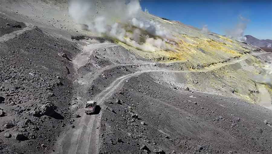
Volcán Lastarria, also known as Azufre, is a massive stratovolcano standing on the border between the Antofagasta region in Chile and the Catamarca Province in Argentina. A precarious mining road south of the summit reaches a staggering elevation of 5,324m (17,467ft) above sea level, ranking it among the highest roads in the country.
Why is it called Lastarria Volcano?
The volcano owes its name to José Victorino Lastarria (1817–1888), one of Chile's most influential intellectuals and politicians. Lastarria was a key figure in describing the hidden riches of the Atacama Desert during the 19th century. In his works, he documented the presence of the "Azufre" (Sulfur) volcano, following the scientific observations of the naturalist Rodulfo Amando Philippi. This historical connection adds a layer of cultural depth to the mountain, linking the era of great Andean explorations with the modern-day quest for high-altitude adventure.
The peak is situated in one of the most desolate and remote environments on Earth, within the northern end of the Lazufre volcanic region. This area is about 93 miles (150 km) from the nearest inhabited place, making any expedition here a high-stakes undertaking. The mountain is famous for its intense yellow sulfur deposits and its constant, powerful fumarolic activity, which has been active for over 70 years along the summit and the northwestern slopes.
| Road facts: Volcán Lastarria | |
|---|---|
| Location | Chile - Argentina border (Central Andes) |
| Elevation | 5,324 m (17,467 ft) |
| History | Named after José Victorino Lastarria |
| Hazard Level | Extreme (Altitude & Toxic Gases) |
| Surface | Unmarked Mining Tracks / Volcanic Ash |
How do you navigate the mining roads to Lastarria?
Accessing the high-altitude tracks of Volcán Lastarria is a formidable technical challenge. The primary route approaches from the Chilean side, utilizing unmarked mining roads that wind through abandoned sulfur extraction sites near the southwestern base. These trails were originally carved out for industrial purposes but have long been neglected, leaving a surface of loose volcanic ash, sharp obsidian rocks, and deep sand drifts. Because these routes are not marked on standard maps, drivers must rely on high-resolution satellite imagery and specialized navigation software.
The terrain is highly unpredictable. High-altitude winds frequently reshape the landscape, burying the track under fresh drifts of sand. In winter and early spring, the road can be blocked by penitentes—sharp spikes of hardened snow and ice that can reach several feet in height. A high-clearance 4x4 vehicle with heavy-duty tires is a basic requirement for survival in this terrain.
Why is the Volcán Lastarria drive considered dangerous?
The dangers go far beyond the technical difficulty of the road. At 5,324 meters, the air contains only about half the oxygen available at sea level, leading to extreme hypoxia. Internal combustion engines lose significant power at this elevation, often struggling to maintain torque on steep, sandy slopes. Furthermore, the air near the summit can become saturated with toxic volcanic gases from the active fumaroles, which can be harmful to breathe and corrosive to equipment.
There is absolutely zero infrastructure or emergency support within a 150 km radius. A mechanical failure or medical emergency here means being stranded in a freezing environment where rescue could be days away. Total self-sufficiency, including supplemental oxygen, industrial-grade masks for sulfur gases, extra fuel, and satellite communication, is mandatory for any expedition to this Andean giant.
Road suggested by: Hugh Wilson
Pic&video: YUKOPILOT