How to drive the unpaved Ruta Lapislázuli to Paso la Chapetona?
Paso la Chapetona, also known as Paso del Azufre Norte, is a high mountain pass at an elevation of 3,654m (11,988ft) above sea level, situated on the border between Chile and Argentina. For drivers, this is a dead-end mining track known as Ruta Lapislázuli, which climbs the Andes from the Chilean side toward the mineral deposits of the Coquimbo Region.
| Road facts: Paso la Chapetona | |
|---|---|
| Location | Coquimbo (Chile) - San Juan (Argentina) border |
| Elevation | 3,654 m (11,988 ft) |
| Length | 25 km (from Monte Patria side) |
| Vehicle Required | High-clearance 4x4 mandatory |
Can you drive across the border at Paso la Chapetona?
Motorized access is only possible on the Chilean side. The 25-kilometer track from Monte Patria serves the Los Azules and Los Altares mines. At the summit of Paso la Chapetona, the vehicle track ends. On the Argentinian side, toward Calingasta, the path becomes a primitive mule trail, making it impossible for cars or 4x4s to cross the border. The route must be driven as an out-and-back journey.
What is the road condition of Ruta Lapislázuli to Paso la Chapetona?
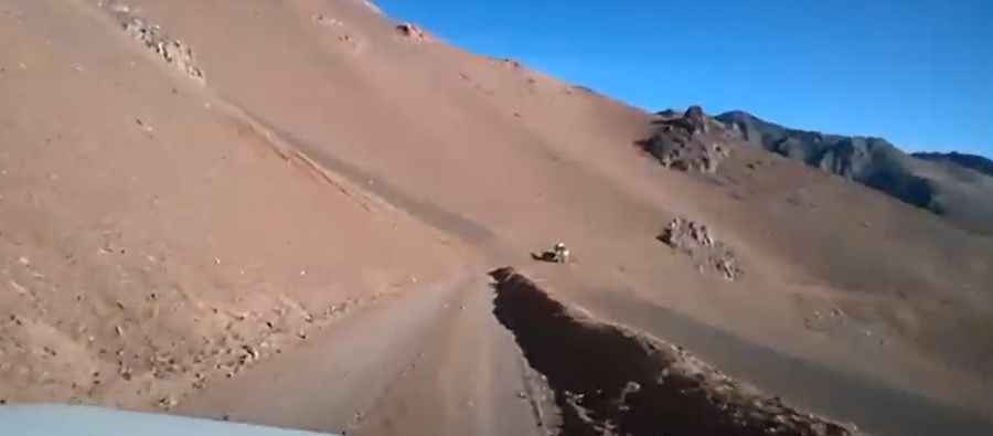
The road is an unpaved mining track consisting of loose rock, scree, and deep dust. The path is narrow and carved into steep slopes with no safety barriers or guardrails. Snowmelt causes heavy erosion, leaving deep ruts and washouts that require high ground clearance. Traction is poor on the limestone debris, making a 4x4 with low-range gearing required to clear the steepest ramps before reaching Paso la Chapetona.
Is the road to Paso la Chapetona open in winter?
Paso la Chapetona is blocked by snow from June to October. At nearly 3,700 meters, high-velocity winds and freezing temperatures are common even in summer. The track is not maintained for civilian use; its condition depends entirely on active mining operations. Without regular maintenance, rockfalls and landslides quickly block the narrowest sections.
What are the mechanical risks of the climb to Paso la Chapetona?
Engine power drops significantly above 3,000 meters on the way to Paso la Chapetona, which can cause overheating on the steep gradients. Drivers must carry extra fuel and at least two full-size spare tires, as the sharp volcanic rocks frequently slice sidewalls. On the 25-kilometer descent back to Chile, engine braking in low gear is required to prevent boiling the brake fluid on the loose gravel switchbacks of the Ruta Lapislázuli.
What should you expect at the summit of Paso la Chapetona?
Reaching the summit of Paso la Chapetona offers total isolation with no facilities, water, or mobile signal. The landscape is a barren high-altitude desert. Meeting oncoming mining machinery on the narrow ledge is a major risk, often forcing a dangerous reversing maneuver on the cliff edge. Any driver must have a clear turnaround plan before the track disappears at the border line of Paso la Chapetona.
Road suggested by: Jorge Manuel Gómez Sánchez
Pic&video: Diario El Sol De Calingasta