Cerro Juquel: Driving the steep 9.5% climb in Potosí, Bolivia
Located in the remote Potosí Department of southwestern Bolivia, Cerro Juquel is a high mountain peak reaching an elevation of 4,612m (15,131ft) above sea level. This peak is a landmark in the desolate Andean landscape, known for its technical access road that serves a communication tower at the summit and offers some of the most dramatic views of the surrounding salt flats and volcanic terrain.
| Road facts: Cerro Juquel | |
|---|---|
| Location | Potosí Department, Bolivia |
| Elevation | 4,612 m (15,131 ft) |
| Length | 9.01 km (5.60 miles) |
| Elevation Gain | 856 m |
| Average Gradient | 9.5% |
Where is the road to Cerro Juquel?
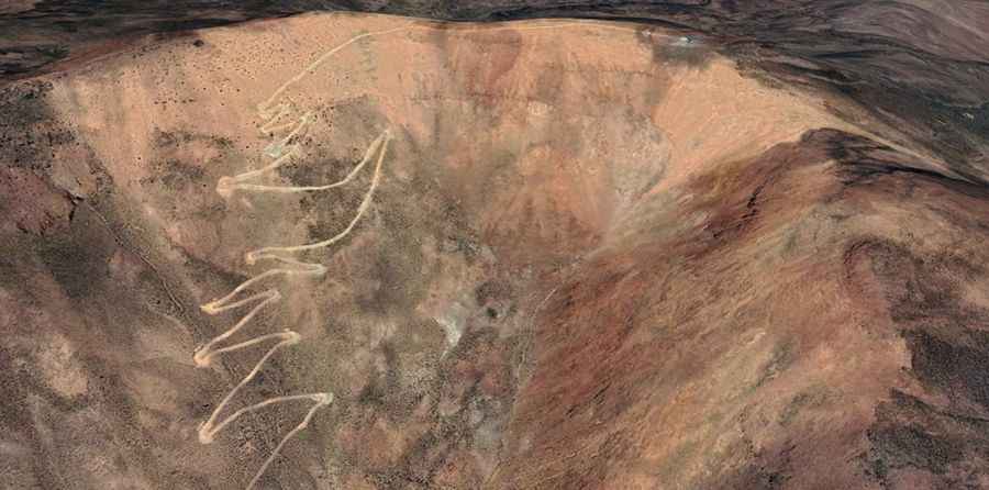
The road starts from the vicinity of the Hostal De Sal La Escondida, a typical salt-constructed lodging in the Altiplano. From there, the track strikes upward into the dry, rocky mountainside of the Potosí region. This is a land of extreme isolation where the geography is defined by volcanic minerals and thin air. The ascent is 9.01 km (5.60 miles) long, and as you climb, the ground becomes increasingly loose and technical. This is definitely not a place to explore if unpaved mountain roads aren't your strong point.
Is the road to Cerro Juquel unpaved?
Yes, the road to the summit is totally unpaved and consists of a narrow, rocky track that demands a 4x4 vehicle. The trail is pretty steep and features 19 sharp hairpin turns that snake up the mountain’s flank. These switchbacks are tight and often have significant drop-offs, so stay away if you're scared of heights. The surface is composed of high-altitude gravel and volcanic soil which can lose its grip easily, especially on the ramps where the 9.5% gradient forces the engine to work at its limit while fighting for traction.
How challenging is the climb to Cerro Juquel?
The challenge of Cerro Juquel lies in the combination of steepness and altitude. Over the 9 km course, you will tackle an elevation gain of 856 meters, resulting in a relentless average gradient of 9.5%. At over 4,600 meters, your vehicle's engine will struggle with the lack of oxygen, potentially losing a significant portion of its power. Low-range gearing is essential to maintain a steady pace through the hairpins. The communication tower at the top serves as a final waypoint, but the true reward is the panoramic view of the desolate Potosí wilderness that few travelers ever get to see.
What are the weather hazards at Cerro Juquel?
The weather in the Bolivian southwest is harsh and unpredictable. Even in the dry season, high winds are a constant factor at the summit, which can make steering a high-profile vehicle tricky on the exposed hairpins. Temperature drops are rapid as soon as the sun goes down, often falling well below freezing. If you encounter any moisture, the volcanic dust can turn into a slippery paste, making the 9.5% grade a dangerous slide. Always check local conditions and ensure you are carrying recovery gear, extra fuel, and warm clothing before leaving the salt plains behind.