Death Road in Bolivia is the world's most famous gravel track
Carretera de los Yungas is probably the most famous road in the world. This gravel dirt track covers a 36.4km (22.61 miles) stretch between La Paz and Coroico, in the Yungas area of the Bolivian department of La Paz. Known globally as the "Death Road," it is a place where engineering limits meet raw human fear.
How long is the Death Road in Bolivia?
The road is 36.4km (22.61 miles) long, the main route from La Paz to Coroico. To be fair, it’s technically not considered the “World’s Most Dangerous Road” anymore due to the construction of a new highway (Ruta Nacional 3) close by, which directs most traffic away from its path. The thin road climbs jungle-clad mountains to a height of 3,151m (10,337ft) above sea level, winding and turning all the while with nauseatingly deep canyons below. If you get dizzy, be sure to avoid this road at all costs.
Has anyone died on Death Road in Bolivia?
This road was legendary for its extreme danger, with an estimated 200 to 300 people traveling on it dying each year. Dozens of vehicles went off the road annually, and with vertical drops of up to 1000m over the edge, annual fatalities reached into the hundreds. The road connects the Amazon rainforest region of northern Bolivia, or Yungas, to its capital city, including macabre crosses marking many spots where vehicles have fallen. Some of the most important accidents happened on 24 July 1983 when a bus veered off the Yungas Road and into a canyon, killing more than 100 passengers, in what is said to be Bolivia's worst road accident. In December 1999, 8 Israeli travelers were killed in a jeep accident on that road.
Do they drive on the left in Bolivia?
While the rest of Bolivia drives on the right side, here vehicles drive on the left. This unique rule is a survival tactic: a driver on the left has a better view of the edge of the road, allowing them to stare right into the 1,000-meter drop to ensure their tires aren't slipping into the abyss. Descending vehicles never have the right of way and must move to the outer edge of the road. This forces fast vehicles to stop so that passing can be negotiated safely on a rocky path that is often swathed in cloud and waterfalls. It was the "black widow" of roads, notorious for being the most treacherous stretch in the world.
What is the actual name of the Death Road?
The former world’s most dangerous highway is alternatively known as Death Road, Grove's Road, Coroico Road, Camino de las Yungas, El Camino de la Muerte, Road of Death, or Unduavi-Yolosa Highway. Over the years, countless vehicles (particularly buses) have gone tumbling down the 3,000-foot cliffs that line the road due to minor miscalculations.
How dangerous is Death Road?
Based on the ratio of death per mile, on average, 26 vehicles plummet over the edge each year, claiming more than 100 lives. In 1995, the Inter-American Development Bank christened this highway "The Most Dangerous Road in the World.” It’s barely the width of one vehicle, with no guardrail to protect you from falls of up to 2,000 feet. Rain can make the road muddy and slippery, and rain or fog can reduce a driver to feeling blindfolded. Unlike the Million Dollar Highway in Colorado where you have asphalt, here you are fighting loose gravel and mud on a 3-meter wide track.
The Ultimate Comparison: Which one is truly the deadliest?
To understand the scale of the Death Road, we must compare it with the other "titans" of dangerous driving. Here is how it stands against the legendary Million Dollar Highway and the treacherous D915.
| Feature | Death Road (Bolivia) | Million Dollar Hwy (USA) | D915 (Turkey) |
|---|---|---|---|
| Fear Factor | The "Abyss" (No barriers) | Sweaty Palms (Altitude) | The "Stairway to Hell" |
| Main Hazard | Fog & Vertical drops | Avalanches & Black Ice | 29 Hairpin turns |
| Surface | Unpaved (Gravel/Mud) | Fully Paved (Asphalt) | Unpaved (Loose rock) |
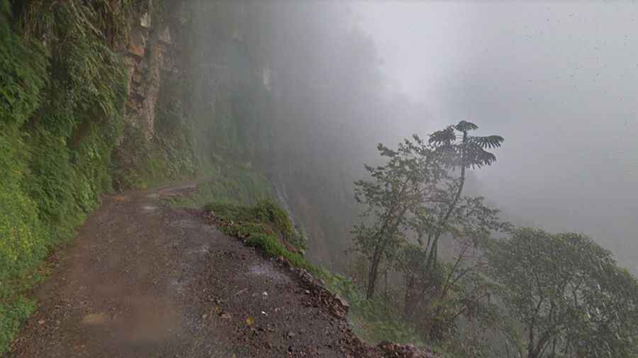
Why is Yungas Road so dangerous?
The road is especially dangerous because it is only 3 meters wide and was navigated by trucks and buses, because its constant sheer drops of at least 600m without any barriers or guardrails. The extreme dust clouds in summer and fog all year round often reduce visibility to almost zero. To make matters worse, waterfalls crash down onto its surface in places, and drivers will likely encounter groups of cyclists during the treacherous journey.
Can you still drive the Death Road?
Starting in the 1990s, the road is now a popular tourist destination drawing some 25,000 thrill-seekers. But the road has no mercy; at least 20 cyclists have died on the ride since 1998. Meeting a truck on a 3-meter wide track with a 600-meter drop is a game of chicken where someone has to reverse on loose dirt.
Located to the south, the South Yungas Road (called Chulumani Road), is considered to be nearly as dangerous as the North Road and links Nuestra Señora de La Paz and Chulumani. This ridiculously tight road includes 600 meters (1,830 feet) drops and is full of hairpins.
How to drive the Death Road? (Tips for Survivors)
- Follow the edge: If you go down, always stay on the outer edge (the left) — that is a rule that locals follow.
- Do not rent a car in Bolivia: Most local rental vehicles are not maintained for these extreme conditions.
- Weather is key: Avoid visiting after heavy rain, as the unpaved surface becomes treacherous.
- Local Expertise: We highly recommend exploring this route with local experts who know every inch of the cliffside.
Death Road or D915 Road in Turkey?
While the Death Road holds the crown for notoriety, many extreme drivers now point to the Turkish coast as the ultimate challenge. As seen in our comparison above, the D915 from Bayburt to Of lacks the tourist infrastructure found in Bolivia. It remains a raw, local mountain pass where the 29 hairpin turns are not an attraction, but a daily life-or-death struggle. If you think you've conquered the Yungas, the loose rocks of the Trabzon region are waiting for you.