How to get by car to the communication tower at Cerro Juquel in Potosí?
Cerro Juquel is a high mountain peak at an elevation of 4,612m (15,131ft) above sea level, located in the Potosí Department of Bolivia.
Where is Cerro Juquel?
The peak is located north of San Juan, in the southwestern part of the country.
Why is there a road to Cerro Juquel?
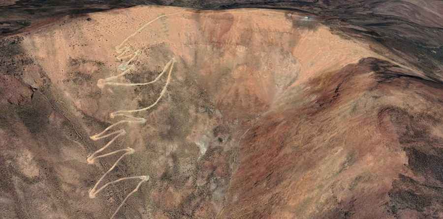
The road was built to reach a communication tower at the top. This is a dead-end route that serves only the equipment at the summit. A 4x4 vehicle with low-range gearing is required.
Is the road to Cerro Juquel unpaved?
The road to the summit is totally unpaved running through dry, volcanic slopes. It is a narrow ledge won from the rock, with constant exposure to the wind and steep drops. The surface consists of loose volcanic ash, crushed rock, and fine dust. The drive is pretty challenging, with 24 hairpin turns.
How long is the road to Cerro Juquel?
Starting from Bella Vista, the road to the summit is 9.3 km long. Over this distance, the elevation gain is 882 m and the average gradient is 9.48%.
How remote is the drive to Cerro Juquel?
Situated in the harsh Altiplano environment, the area is completely isolated, with no mechanical support, water, or mobile coverage. Mechanical self-sufficiency is mandatory; you should carry a full-size spare tire, extra fuel, and basic recovery tools, as a breakdown here means a long and dangerous wait in extreme Altiplano conditions.