How to drive the unpaved Paso Osipal in the Apolobamba Range?
Paso Osipal is a high mountain pass at an elevation of 4,887m (16,033ft) above sea level, located in the Department of La Paz, Bolivia. Also known as Abra de Sorapata, this remote track crosses the Apolobamba mountain range and sits within the Ulla Ulla National Fauna Reserve, making it one of the most secluded and high-altitude drives in the Andes.
| Road facts: Paso Osipal | |
|---|---|
| Location | La Paz Department, Bolivia |
| Elevation | 4,887 m (16,033 ft) |
| Length | 23.3 km (14.4 miles) |
| Surface | Unpaved / Dirt and Rock |
| Permit | Mandatory (SERNAP office) |
Where is the road to Paso Osipal?
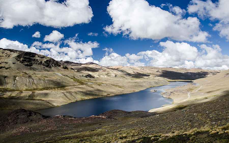
The track connects the settlements of Hilo Hilo and Puyo Puyo, winding through deep valleys and past glacial lakes. This is a protected natural area, so you cannot just show up and drive; you need a permit from the SERNAP office in La Paz. Park rangers watch over the area to ensure the wild nature is respected, and they are your only hope for help if you get stuck. The scenery is dominated by the snowy peaks of the Ullakaya and Condorini massifs, but don't let the views distract you—the ground is treacherous.
Is the road to Paso Osipal unpaved?
Yes, the road is entirely unpaved and looks like many of the old mining tracks in the region that have been reclaimed by nature. In the photo, the road is barely visible as a thin line hugging the right side of the lake. A high-clearance 4x4 vehicle is not just recommended; it is mandatory. You will face sections of loose dirt, sharp stones, and even swampy glens known as "bofedales". These humid highlands can be a trap for heavy vehicles; if you don't find the firmest path, you’ll end up with your tires buried in the mud.
How long is the drive through Paso Osipal?
The journey between Hilo Hilo and Puyo Puyo is 23.3 km (14.4 miles) long. While the distance seems short, the elevation gain is nearly 1,000 meters, reaching the pass at 4,887m. The climb is long but gradual, yet the thin air will make your engine lose power significantly. After the main pass, the track continues to climb toward a higher plateau at 5,110 meters before a long, sandy descent towards Lake Pujo Pujo. It is a slow-motion grind where you have to monitor your vehicle's temperature and traction constantly.
What are the driving hazards at Paso Osipal?
The biggest risk here is the isolation and the changing terrain. The "road" is often used as a trekking route because of its poor condition. You will encounter sandy areas and rocky outcrops that can easily damage your undercarriage. Because it’s a glacial area, meltwater can wash away parts of the track or turn the dirt into a slippery mess without warning. There are no services, no cell signal, and very few people. If you decide to drive through this hidden gem, make sure you are fully self-sufficient and prepared for a high-altitude mechanical struggle.
Road suggested by: jorge manuel gómez sánchez
Pic&more info: https://www.travels-bolivia.com/travel-bolivia/andean-treks/trekking-in-the-apolobamba-cordillera/#gallery-4