How difficult is the high-altitude road to Paso Salar Capina in Bolivia?
Paso Salar Capina is a high mountain pass reaching an elevation of 4,654m (15,269ft) above sea level, located in the Potosí department of southwestern Bolivia. Situated in the heart of the Andes near the Chilean border, the road to the summit is a raw, unpaved track that crosses one of the most desolate landscapes on Earth. This is a journey through the Altiplano, where the extreme altitude and the shifting sands of the volcanic soil turn a 26-kilometer drive into a grueling test for both the vehicle's cooling system and the driver's endurance.
| Road facts: Paso Salar Capina | |
|---|---|
| Location | Potosí, Bolivia (near Chile) |
| Elevation | 4,654 m (15,269 ft) |
| Length | 26.4 km (16.4 miles) |
| Surface | Unpaved / Volcanic sand / Corrugated dirt |
| Hazard Level | High (Isolation & Thin air) |
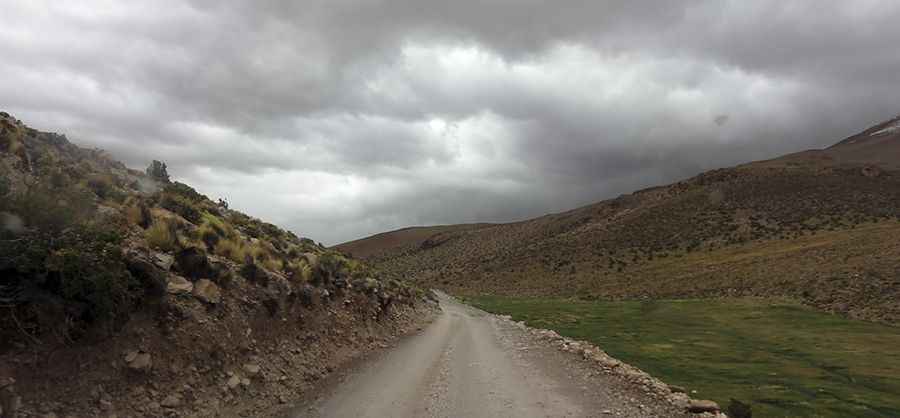
How is the drive on the 26 km track to Salar Capina?
The road through the pass is 26.4 km (16.4 miles) long, running north-south from Villa Mar toward Laguna Capina. The climb involves a significant elevation gain of over 700 meters, mostly over a surface of loose volcanic sand and heavy "calamina" (washboard) ripples. As seen in the Potosí highlands, the track is often just a set of parallel ruts in the dirt, where the wind constantly erases the path. A high-clearance 4x4 is mandatory; standard vehicles will struggle to find traction in the soft patches and the violent vibrations from the corrugated surface can easily snap suspension components in the middle of nowhere.
What are the main hazards of driving in southwestern Bolivia?
The primary hazard at Paso Salar Capina is the absolute isolation. You are driving in a high-altitude desert where help is non-existent and mobile coverage is a dream. The weather is unpredictable; while it is usually bone-dry, sudden temperature drops can freeze your diesel, and the intense UV radiation makes the track surface brittle and sharp. The wind on the Altiplano is another major factor; it can kick up blinding dust storms in seconds, hiding the deep ruts and rocky outcrops that line the route. There are no safety barriers or road signs; you must drive with a full-size spare tire and enough water to survive a breakdown at 4,600 meters.
Why is the 4,654m altitude a danger at Paso Salar Capina?
Driving at 4,654 meters is a brutal experience for any engine. Naturally aspirated vehicles lose nearly 40% of their power, making the steep ramps of the climb feel like a desperate struggle for momentum. The cooling system is also under massive stress because water boils at a much lower temperature in the thin air, increasing the risk of the radiator blowing over despite the cold outside. For the driver, altitude sickness is a constant threat; the lack of oxygen leads to fatigue and slower decision-making, which is lethal when navigating a track where losing your line means getting stuck in deep sand or hitting a volcanic rock.
When is the best time to cross the Salar Capina pass?
The best window for the drive is the dry season, from May to October. During the Bolivian "winter" (the rainy season), the area around Laguna Capina can turn into a treacherous slurry of mud and salt, making the unpaved road completely impassable even for heavy-duty 4x4s. Even in the dry season, nighttime temperatures at the 4,654m summit regularly drop well below -10°C. This is a journey that requires total self-sufficiency: carry extra fuel in jerricans, a satellite phone if possible, and thermal gear. If your vehicle fails here, you are facing a life-threatening situation in one of the most beautiful but unforgiving corners of the Andes.
Pic: don Senen