Lippincott Mine Road in California is for experienced 4WD drivers and vehicles only
Lippincott Mine Road is a very challenging drive located in Inyo County, in the U.S. state of California. It’s a faster route to the park than others, but you might be clenching your jaw the whole way, trying not to fall hundreds of feet to oblivion, and it’s not for the casual driver or the casual car. It’s one of the challenging Backcountry roads in Death Valley National Park.
Where is Lippincott Mine Road?
The road is located halfway between Lone Pine and Stovepipe Wells in the eastern central part of California, within Death Valley National Park.
How long is Lippincott Mine Road in Death Valley National Park?
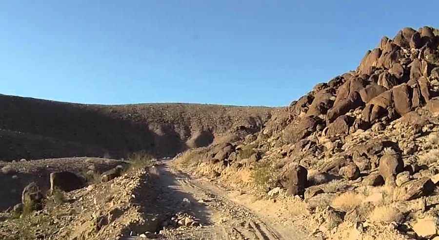
The road is totally unpaved. It’s 11.26 km (7.0 miles) long, running east-west from Racetrack Valley Road to Saline Valley Road.
Is Lippincott Mine Road open to passenger vehicles?
The road is for experienced drivers using 4×4 high clearance vehicles only. You'll need a good map, as the routes are not marked and there are no signs. Maintained only to 4WD standards. The signs posted at each end of the road say it all by warning: "CAUTION - ROUTE AHEAD NOT MAINTAINED - WASH OUTS AND CUT BANKS AHEAD - ROUTE NOT RECOMMENDED FOR VEHICLE TRAVEL - EXPERIENCED DRIVERS USING 4X4 HIGH CLEARANCE VEHICLES ONLY." This is a dangerous mining area. There are lots of scary holes in the ground that are fun to look at, but not safe to enter.
Is Lippincott Mine Road in Death Valley National Park difficult?
The road is very challenging. There are no guardrails, and there is a constant threat of a steep fall if you’re not careful — at times, there’s just a foot or two of gravelly space to navigate. The road is very steep, narrow, and winding with cliff edge washouts. You’ll be driving around or over some large rocks that could break your vehicle, and if that doesn’t do it, the park’s intense heat could if you’re making the climb into Death Valley during the hotter months. There’s no towing service, no water source, no road signs, and no cell reception. The climb gets very serious; this is slow, low-range work. There are washouts, most of which have been repaired with rocks, and in places you'll only have a foot or so between your outside tire and a disaster. The drop gets hairy, too --hundreds of feet, not straight down, but not enough of a slope to matter-- a mistake would be fatal. There's an additional problem: if there's a breeze in the canyon, it will be coming from behind you, which, coupled with the low-range hard climb, can cause overheating.
When was Lippincott Mine Road in Death Valley National Park built?
The road was built in 1906 to give access to Lippincott Mine. Uphill traffic has the right of way. The lower part has a very narrow section that is difficult for wide vehicles. This road is insanely dangerous. Steep drop-offs on the driver's side the whole time make for quite the pucker factor. It seems like the road has started to wash out in many spots making for a very narrow ride. Unless you’re in a high clearance vehicle, stay away. And even then, don’t go. This road is very hard to negotiate except by 4 x 4. Bring a pickaxe, shovel, some boards for ramps, lots of water, spare tires, and survival gear. This is one of the most challenging and exciting 4WD roads in Death Valley.
Is Lippincott Mine Road in Death Valley National Park open?
The trail (on some maps, it is identified as Ubehebe Road) should be open most of the year with the elevation running from 3,876ft down to 2,256ft. The road tops out at a saddle. This isn't the summit, but it's a good stopping point, and the view is fantastic. Subject to closure after washouts from heavy rains. There's room to park with your grill in the wind to let things cool. Due to frequent flooding in the area, road conditions often vary throughout the park. For the most up-to-date information on road conditions, visit Death Valley’s website at nps.gov/deva.