Chute Canyon Road: Driving through the San Rafael Reef in Utah
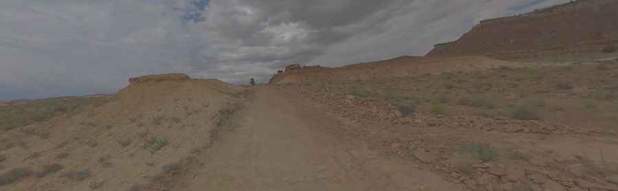
Located in the heart of Emery County, Utah, Chute Canyon Road is a stunning backcountry route that pierces through the dramatic limestone fins of the San Rafael Reef. Designated as CO 1016, this drive is a journey into the rugged isolation of the San Rafael Swell, offering a mix of geological wonders and historical remnants of Utah’s intense mining past.
| Road facts: Chute Canyon Road (CO 1016) | |
|---|---|
| Location | Emery County, Utah, USA |
| Max Elevation | 1,770 m (5,807 ft) |
| Length | 10.13 km (6.3 miles) |
| Surface | Unpaved / Sandy / Rocky |
| Vehicle Required | 4WD High Clearance |
Where is Chute Canyon Road?
The road is situated in central Utah, slicing through the jagged southern edge of the San Rafael Swell. This desert corridor is a visual spectacle, where the flat desert floor suddenly gives way to massive, tilted layers of rock. The track runs entirely above 1,660m, providing a high-altitude desert experience where the landscape is dominated by deep canyons, sheer cliffs, and the vast silence of the Bureau of Land Management (BLM) territories.
Is Chute Canyon Road unpaved?
The road is totally unpaved and varies significantly in condition. Depending on recent weather, the surface shifts from deep, soft sand to stretches of jagged rock and dry wash beds. The track is rough in many places, following the natural contours of the canyon floor. This is a route where high-clearance 4WD vehicles are not just recommended, but essential. Standard passenger cars will likely bottom out or lose traction in the sandy sections. During and after storms, the clay and sand can become a treacherous sludge, making the road impassable even for the most capable off-roaders.
How long is Chute Canyon Road?
The drive covers 10.13 km (6.3 miles), reaching its highest point at an elevation of 1,770m (5,807ft) above sea level. While it is a relatively short distance, the slow going over rocky terrain means you should allow plenty of time to navigate the technical sections. The road is incredibly remote, so never drive this trail alone. Self-sufficiency is mandatory; you need to be prepared with extra water, fuel, and a full-size spare tire, as there is zero cell service and help can be hours or days away.
What is the mining history of Chute Canyon?
Driving along CO 1016, you will encounter numerous remnants of the region's mining heritage. Prospecting began in these canyons in the late 1800s, but the area truly boomed during the uranium rush of the 1950s. The road itself was largely improved to allow heavy trucks to haul ore out of the desert. Today, you can still see old mine adits, rusted equipment, and tailing piles that tell the story of the miners who braved the extreme temperatures and isolation of the Swell in search of "yellowcake" uranium.
Is Chute Canyon Road dangerous in summer?
Summer travel brings two life-threatening risks: heat and water. Temperatures in Chute Canyon can easily rise well into the 100°F (38°C) territory, and the canyon walls provide little shade, reflecting the heat back onto the road. More importantly, this area has an extremely high flash flood danger. Because the road follows a natural drainage system, a storm miles away can send a wall of water and debris through the canyon in minutes. Always check the local weather report and avoid the canyon if any rain is forecasted for the San Rafael Swell area.
What gear do I need for the San Rafael Swell?
Beyond a capable 4x4, your vehicle should be equipped for extreme desert conditions. Carry at least one gallon of water per person per day. In the event of a breakdown, stay with your vehicle; wandering into the San Rafael Reef without a plan is a recipe for disaster. Additionally, ensure you have a shovel and traction boards (like Maxtrax), as getting bogged down in the sandy washes of Chute Canyon is a common occurrence for those who don't air down their tires.
Pic: Shannon Bushman