How high is the Hell's Backbone Bridge in Utah?
Hell's Backbone Bridge is a high-mountain concrete deck girder bridge spanning 33.2 meters (109 ft) across the deep Sandy Creek Gorge in Garfield County, southern Utah, USA. Suspended above a 460-meter (1,500 ft) vertical drop into rugged canyons, the bridge carries Hell's Backbone Road between Escalante and Boulder. It's one of the most spectacular bridges in the world along the Hell's Backbone Road.
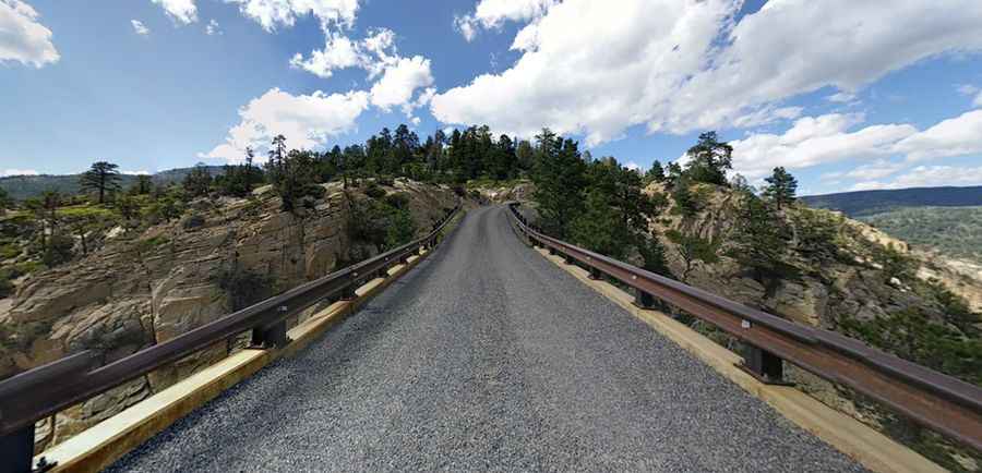
| Road facts: Hell's Backbone Bridge | |
|---|---|
| Location | Garfield County (Dixie National Forest), Utah (USA) |
| Route Designation | Hell's Backbone Road (Forest Road 153) |
| Length | 33.2 m (109 ft) |
| Width | 4.3 m (14 ft) single-lane width |
| Vertical Drop | 460 m (1,500 ft) sheer drop on both sides |
| Build Date / Replacement | Built 1933 (CCC timber bridge) / Replaced 2005 (Steel/concrete) |
| Surface | Concrete bridge deck, unpaved gravel road approaches |
| Access Status | Seasonal (Closed in winter after first major snowfall) |
Where is Hell's Backbone Bridge located?
The bridge is situated along Hell's Backbone Road in the Dixie National Forest, connecting the towns of Escalante and Boulder in southern Utah. The single-lane bridge rests on a narrow rocky ridge known as the Spine, with sheer gorge drops plunging 1,500 feet on both sides.
How was Hell's Backbone Bridge built?
The original wooden structure was built in 1933 by the Civilian Conservation Corps (CCC) to open a direct route through the Boulder Mountain area. After decades of heavy use, the timber framework creaked and deteriorated under vehicle traffic, prompting a complete reconstruction in 2005 into a modern steel-reinforced concrete deck girder bridge. Remnants of the original 1933 timber beams are still visible along the rock faces beside the road.
Is the road to Hell's Backbone Bridge paved?
No. Hell's Backbone Road is a rural gravel dirt track that is occasionally graded. While standard 2WD passenger vehicles can handle the unpaved surface during dry weather, heavy rain creates deep ruts, and winter snowstorms render the high-altitude pass completely impassable until spring snowmelt.
What are the driving conditions on Hell's Backbone Bridge?
The bridge itself measures just 14 feet wide, allowing only one vehicle to cross at a time. The narrow gravel road approaches run along a knife-edge cliff top where drivers encounter 1,500-foot vertical drops without guardrails along the access road, leaving zero margin for error during high winds or slick muddy conditions.
Pic: Isaac Gifford