Scotts Pass: Driving the defiant NF-029 in the Wasatch Crest Ridge
Scotts Pass is a high-altitude mountain gap situated at an elevation of 2,892m (9,488ft) above sea level in Salt Lake County, Utah. Located along the prominent Wasatch Crest Ridge, the road to the summit—the NF-029—is a demanding unpaved track that serves as a rugged link between the Big Cottonwood and Park City ridgelines. This is not a standard forest drive; it is a high-mountain transit where the technical integrity of the roadbed and the exposure to steep drops define every mile of the climb.
| Road facts: Scotts Pass | |
|---|---|
| Location | Wasatch Mountains, Utah (USA) |
| Max Elevation | 2,892m (9,488ft) |
| Length | 11.8 miles (19 km) |
| Surface | Unpaved / NF-029 Track |
How challenging is the 11.8-mile climb from UT-224 to Scotts Pass?
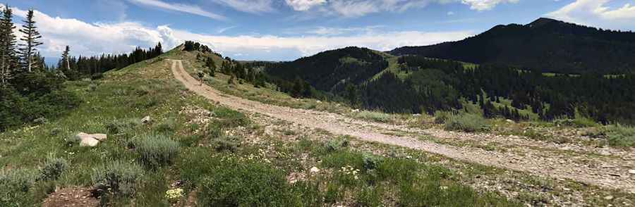
The journey to the summit starts from the paved UT-224 and spans 11.8 miles through the Wasatch Range. The challenge of this route is the surface condition; the NF-029 is a mix of gravel and hard-packed dirt that develops severe washboards in many sections. These ripples can rattle a vehicle’s suspension to its limits and reduce braking efficiency significantly. As the road approaches the pass, the terrain becomes increasingly steep with technical drop-offs that require a steady hand on the wheel. A high-clearance 4x4 vehicle is mandatory to clear the deep ruts and the occasional rockfall that litters the driving line near the Brighton Ski Resort area.
Why is the Wasatch Crest Ridge weather a major hazard?
At nearly 2,900 meters, Scotts Pass is fully exposed to the volatile mountain weather of Utah. The road is typically impassable from October to June due to heavy snow accumulation, but even in the summer, major storms can transform the track into a treacherous muddy slide in minutes. Flash floods frequently wash away the gravel, exposing sharp stones that can easily puncture a tire sidewall. Navigating the NF-029 during or after a storm requires advanced off-road skills, as the traction on the steeper unpaved ramps vanishes, leaving the vehicle vulnerable to sliding toward the unprotected edges of the ridge.
What are the hazards of the steep drops on the NF-029?
The geography of Scotts Pass is defined by its position on the southern end of the Wasatch Crest. This means the road often follows narrow ledges with significant vertical exposure. The lack of guardrails and the crumbly nature of the road shoulders mean that any steering error on the steep hairpins can have immediate consequences. When descending back toward the valley, managing your speed is vital; relying only on the foot brake will lead to overheating due to the sustained downhill gradients. Using low-range gears and engine braking is the only way to safely descend the 11.8 miles without risking brake fade on the technical gravel sections.
What mechanical preparation is needed for the Scotts Pass transit?
Driving to 2,892 meters is a journey that demands a full mechanical audit of your vehicle before leaving the asphalt. The constant vibration from the washboard sections can loosen bolts and stress the cooling system, which is already working harder due to the thin air of the Wasatch. You must carry essential recovery gear, including a full-sized spare tire and tools for trail-side repairs, as the pass is isolated from immediate emergency services. Before starting the 11.8-mile climb, ensure your tires are aired down slightly to improve traction on the loose gravel and that your cooling system is flushed to handle the high-rev, low-speed work required to clear the ridge hairpins.
Pic: Yevgeny Morozov