A wild road to Tomichi Pass in Colorado
Tomichi Pass is a high mountain pass at an elevation of 3.657m (11,998ft) above sea level, located in Chaffee County, in the U.S. state of Colorado. It's one of the highest roads in Colorado.
Is the road to Tomichi Pass unpaved?
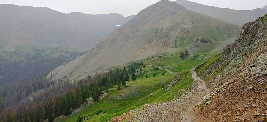
The road to the summit is totally unpaved. It’s called Forest Road 888 and runs north-south from Brittle Silver Basin to the mining town of Whitepine. It’s a steep and narrow shelf road, not recommended for novice drivers or anyone afraid of heights. The trail is suitable for stock, high-clearance SUVs with low-range gearing.
When was the road to Tomichi Pass built?
Located within the Gunnison National Forest, the first road traversing the summit was built in the 1870s.
Is the road to Tomichi Pass in Colorado open?
Set high in the Sawatch Range of the Rocky Mountains of Colorado, this road is usually impassable from late October through late June or early July. In June, the upper section is usually still closed by snow.
Is Tomichi Pass in Colorado steep?
The road to the summit is very steep. Starting at Forest Service Road 839, the ascent is 1.60 km (0.99 miles) long. Over this distance, the elevation gain is 155 meters. The average gradient is 9.68%.
Is the road to Tomichi Pass dangerous?
The road is dangerous based on the narrowness of the trail rather than the road surface. Passing is extremely difficult on the north side. You may have to back up a considerable distance if you meet another vehicle. There are no hard-core obstacles, but several places are moderately rocky. If you are ready to try a difficult trail that doesn’t involve serious rock crawling, this is your opportunity. Don’t start up the trail if someone is coming down even though uphill drivers have the right of way.
How is the road to Tomichi Pass?
The road is quite straightforward and only has two items to note: one being the noticeable shelf road carved on the mountain on the north side, and the other is the bridge that spans an eroded section of the road. The shelf road is not much narrower than many other roads. You won't be able to pass any other vehicles along this section, save for any quads or bikes you might encounter, so it pays to be watching closely for any traffic starting up or down the road. The aforementioned bridge is actually the toughest part of the trail! Sounds funny, but the bridge is in pretty poor shape. If wet, you could slide off and get pretty tippy in the muddy section at one end. The road is pretty smooth for the duration. The southern approach is just your typical forest road. The area is prone to rockslides.
Is the road to Tomichi Pass scenic?
The drive is very scenic and offers a great view of the west side of Hancock Pass and Middle Quartz Creek. Views going up are spectacular, but the driver won’t be able to enjoy them until he reaches the pass. The summit is only about one mile from the fork with Hancock Pass, which makes for a nice and short side trip if you're not wanting to go further south.
Pic: Ryan Hodo