The Most Scenic Drives in America
The United States' geography offers a diverse array of road environments, from low-altitude maritime causeways to high-elevation mountain spines. Beyond their aesthetic appeal, these "scenic" routes represent significant engineering feats, often traversing unstable coastal cliffs or dense Appalachian forests. For the expedition-focused driver, these four corridors are essential benchmarks of North American road design, requiring constant vigilance due to variable weather patterns and extreme environmental exposure.
| USA Scenic Corridors: Technical Data | |
|---|---|
| Primary Maritime Link | Overseas Highway (113 miles of causeways) |
| High-Exposure Coastal | Pacific Coast Highway (Big Sur Sector) |
| Topographical Spine | Blue Ridge Parkway (Appalachian Range) |
| Old-Growth Navigation | Olympic Peninsula Loop Drive |
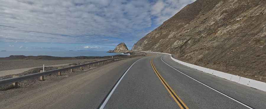
1. Pacific Coast Highway (California)
The Pacific Coast Highway (PCH) is a study in coastal erosion and vertical engineering. The Big Sur section, in particular, carves through unstable cliffs where the road is frequently subjected to landslides and closures. Navigating the iconic bridges and tight radius turns requires total focus, especially during "June Gloom" fog events that can reduce visibility to critical levels. A northbound detour via Highway 101 through the Redwoods adds the challenge of narrow, shaded corridors with extreme moisture levels on the asphalt.
2. Olympic Peninsula Loop Drive (Washington)
Surrounding the Olympic National Park, the Olympic Peninsula Loop Drive is a technical transit through some of the densest old-growth forests in North America. The route balances the low-elevation tranquility of the Hood Canal with the steep, rain-saturated gradients near Lake Crescent. Drivers must account for rapid micro-climate shifts, where snow-capped mountain passes can quickly transition into heavy coastal precipitation.
3. Overseas Highway (Florida)
Extending 113 miles from Miami to Key West, the Overseas Highway is a marvel of maritime infrastructure. Utilizing the bed of the former Overseas Railroad, the route consists of 42 bridges, including the massive Seven Mile Bridge. The primary risk factor here is high-velocity crosswinds and tropical storm surges. Operating on these narrow causeways high above the Atlantic and the Gulf of Mexico provides zero runoff zones, demanding high lane discipline during peak traffic cycles.
4. Blue Ridge Parkway (Virginia)
Running along the spine of the Appalachian Mountains, the Blue Ridge Parkway offers unencumbered views but presents technical challenges in the form of sustained mountain grades and sharp hairpin turns. Designed for low-speed scenic transit, the parkway lacks shoulders in many high-exposure areas. In winter, the high-altitude segments are prone to sudden icing and dense fog, turning this mesmerizing drive into a high-stakes navigational exercise.
Conclusion: The Strategy of Scenic Transit
These "scenic" drives are more than tourist routes; they are logistical corridors that test the endurance of both vehicle and driver. Whether you are managing the crosswinds of the Florida Keys or the coastal instability of Big Sur, success depends on respecting the environmental limits of the terrain. For the professional traveler, the reward is not just the view, but the successful navigation of America's most complex and exposed landscapes.