East Peak: Driving the 20% ski service ramps in the Sierra Nevada
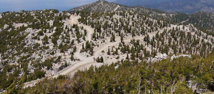
East Peak is a high-altitude mountain peak situated at an elevation of 2,893m (9,491ft) above sea level in El Dorado County, California. Located in the heart of the Sierra Nevada mountains, the road to the summit is a rugged service track used primarily for chairlift maintenance. This is one of the highest roads in California, representing a brutal mechanical challenge where the combination of loose stones and extreme verticality requires a high-clearance 4x4 and advanced off-road driving skills.
| Road facts: East Peak | |
|---|---|
| Location | El Dorado County, California (USA) |
| Max Elevation | 2,893m (9,491ft) |
| Length | 5.9 km (3.6 miles) |
| Max Gradient | 20% |
How technical is the 5.9km climb from Kingsbury to East Peak?
The journey to the summit begins near Kingsbury and covers 5.9 kilometers through the high ridges of the Sierra Nevada. Over this distance, the road gains 638 meters in elevation, making it a prominent entry in the list of Sierra Nevada road passes. The challenge here is the steepness; while the average gradient is 10.81%, several sections hit a punishing 20%. The surface is a mix of gravel and large, loose stones that shift under the tires, making it difficult to maintain traction on the upper hairpins. A high-clearance 4x4 with low-range gearing is mandatory to clear the rockiest parts without damaging the undercarriage.
Why is the summer window so narrow for the East Peak road?
Due to its high elevation and the heavy snowfall characteristic of the California mountains, the road to East Peak is only passable during a very narrow time-frame, typically at the end of August. For the rest of the year, the track is buried under deep snowbanks or blocked by mud from the spring thaw. Even in the height of summer, high winds are constant and sudden storms can bring freezing temperatures and snow to the 2,893m summit. This environmental volatility means that any transit must be planned with a close eye on the weather, as the track can become dangerously slick and impassable for wheeled vehicles in minutes.
What are the hazards of the 20% ramps on a ski service road?
The primary danger of the East Peak track is the sustained thermal load on the vehicle's transmission and cooling system. Climbing 20% ramps on a loose, rocky surface requires a slow, high-torque approach that can easily overheat an engine in the thin Sierra Nevada air. The upper part of the road becomes even steeper and more technical, with ruts from maintenance machinery making the driving line unpredictable. Navigating these sections requires precise throttle control to avoid spinning the tires on the scree, which could lead to an uncontrollable slide on the narrowest shelf sections of the mountain.
What mechanical preparation is needed for the East Peak summit?
Driving to 2,893 meters is a high-consequence task that demands full mechanical self-sufficiency. Because the road serves as a service track for ski-station infrastructure, it is not regularly maintained for public transit. You must carry essential recovery gear, including a full-sized spare tire and heavy-duty jack, as the sharp Sierra granite can easily tear through standard tire sidewalls. On the descent back toward Kingsbury, using low-range engine braking is the only way to manage the 20% gradients safely. Relying on the foot brake will lead to terminal brake fade before you are halfway down the 5.9km track.
Pic: Mark Peterson