Driving the legendary Independence Pass in Colorado
Independence Pass is a high mountain pass at an elevation of 3,692m (12,112ft) above sea level, located on the boundary between Pitkin and Lake counties in the U.S. state of Colorado. It's one of the highest roads in Colorado.
Where is Independence Pass?
The pass is located in the central part of Colorado, in the Sawatch Range of the Rocky Mountains, between Aspen and Leadville, within the White River National Forest.
How many miles is Independence Pass?
The road to the summit is totally paved. It’s called State Highway 82 (CO-82), the Top of the Rockies National Scenic Byway. The pass is about 51km (32 miles) long and connects the upper valley of the Roaring Fork River upstream from Aspen with the headwaters of the Arkansas River near Leadville. The road was not paved until 1967.
Is Independence Pass dangerous?
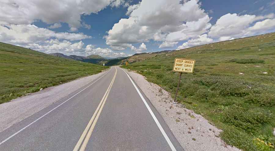
The road through the pass is not for those who fear heights. It is narrow and winding with steep inclines. It’s full of steep drop-offs, tight curves, and narrow stretches that can fit only one car at a time. Portions of the road are a bit tight for most RVs traveling through. And meeting one of these in a one-lane section is exciting. The road is steep with a 6.5% gradient, including tight switchbacks on each approach. Oversized and overweight vehicles are strictly prohibited. Absolutely no vehicles over 35 feet in length may use the road at any time; large RVs are allowed, however. Always keep your eyes on the road and drive slowly while remaining prepared to yield. The tight curves and single-lane segments of the highway require heightened attention by drivers.
Is Independence Pass open?
The pass, originally known as Hunter Pass, is always closed in winters, from the first heavy snowfall in autumn, often opening only in late May or early June. Anytime it can be closed when the access is not cleared of snow. The target reopening date each spring is the Thursday before the Memorial Day holiday weekend. Rockfall remains an issue on this road with occasional rocks in the roadway and even the infrequent road closure. At this elevation, it is said to be the highest paved crossing of the Continental Divide in North America, and the highest paved through road on Colorado's state highway network.
How long does it take to drive Independence Pass?
The drive through Independence Pass, running from Aspen to US 24, might take from 45 minutes to an hour-and-a-half with a few stops along the way to enjoy the scenic views.
Traveling from Vail to Aspen via Independence Pass
Independence Pass is a popular route for those traveling between the ski resort towns of Vail and Aspen. The drive from Vail to Aspen over the pass is a scenic alternative to staying on I-70, taking you through stunning mountain landscapes.
The most direct route is approximately 102 miles and takes around 2.5 hours without stops. However, with sightseeing and breaks, it can easily turn into a full day's adventure. Be sure to check the status of the pass before setting out, as it is closed during winter months.