Conquering the Canwell Glacier Trail, one of the highest roads in Alaska
Canwell Glacier Trail is a very exciting and demanding journey located in Valdez-Cordova Census Area, in the US state of Alaska. This fantastic mountain trail follows the lateral moraine of the Canwell Glacier. It’s one of the highest roads in Alaska.
Where is the Canwell Glacier Trail?
The trail is located north of Paxson, in the southeastern part of Alaska, within the Denali National Park and Preserve. The area was once used for military ski training operations.
Where does the Canwell Glacier Trail start and end?
The remote road is 12.66 km (7.87 mi) long. It’s one way. It leaves the Richardson Highway (63.352170, -145.728577) and terminates at (63.327536, -145.587279). The track eventually ends, and you can cross the glacier to the Canwell Hut, built by the Alaska Alpine Club in the 70s out of Fairbanks.
How demanding is the Canwell Glacier Trail?
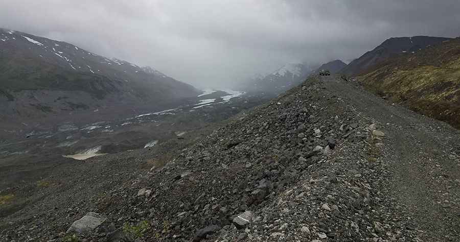
The surface of the trail ranges from gravel to watermelon-sized rocks. Parts of the moraine are eroding into the glacial valley, including part of the moraine that once held the trail. The road includes stream crossings, steep climbs, and amazing glacier views. It is suitable for experienced high-clearance 4x4 drivers only.
Is Canwell Glacier Trail one of the highest roads in Alaska?
Set high in the Delta Mountains of the Alaska Range, the area is subject to strong winds and rapid weather changes. The road sits on top of the southern moraine of the Canwell Glacier and tops out at 1,492m (4,895 ft) above sea level near its end. At this elevation, this road could be the highest road in Alaska, above Atigun Pass on the Dalton Highway at 1,470m (4,822 ft) above sea level.
Road suggested by: Robert Kemper
Pic: Robert Kemper