How to drive the challenging Fordyce Creek Trail in California?
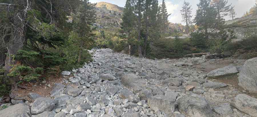
Fordyce Creek is an extremely tough 11.9-mile (19.1 km) off-road trail located in Nevada County, in the US state of California. Set within the Tahoe National Forest, this hard-core 4x4 track is widely recognized as one of the most technical rock-crawling routes in the United States, featuring massive boulder fields and deep water crossings.
| Road facts: Fordyce Creek Trail | |
|---|---|
| Location | Tahoe National Forest, Nevada County, California (USA) |
| Length | 11.9 miles (19.1 km) |
| Surface | 100% unpaved (large boulders, bedrock, deep dust, water) |
| Vehicle Requirements | Modified 4x4 only (Minimum 33" tires, lockers, winch) |
| Trail Features | 5 Winch Hills, 6 Major Water Crossings |
| Hazard Level | Extreme (High rollover risk, severe mechanical damage, flash floods) |
Where is the Fordyce Creek Trail located?
The trail is located in northern California, tucked inside the Tahoe National Forest within Nevada County. It runs through rugged Sierra Nevada terrain alongside Fordyce Creek.
How long is the Fordyce Creek Trail?
The trail spans 11.9 miles (19.1 km) from start to finish. Due to extreme technical obstacles, crawling the full length takes significant time and demanding driver focus.
Can I drive my stock vehicle on Fordyce Creek?
No. Stock vehicles are strictly incapable of clearing this route. Attempting the trail requires a heavily modified 4x4 with a absolute minimum of 33-inch tires and at least one axle locker. Two lockers combined with ultra-low transfer case gearing are strongly recommended. Vehicles with minimal equipment face guaranteed damage and mechanical breakdown.
How challenging is driving the Fordyce Creek Trail?
The route is rated as hard-core and is recommended exclusively for expert off-road drivers. The completely unpaved surface requires tight, technical maneuvering over large, steep, and awkwardly positioned boulders. Section hazards include heavy washboard surfaces, deep silt dust, and five notorious "Winch Hills" that demand maximum vehicle articulation and precise tire placement.
How dangerous is the Fordyce Creek Trail?
The risk factor on Fordyce Creek is severe. Rollovers occur frequently, and body or mechanical damage is a common reality. The trail features six deep water crossings where water levels fluctuate rapidly and without warning due to upstream dam releases and rainfall, rendering crossings completely impassable and stranding rigs between river banks.
When is the best time to drive the Fordyce Creek Trail?
The optimal window to attempt the route is late September until the first winter snowfall. During this autumn period, water flow rates in the creek are typically at their lowest, reducing the depth and current of the river crossings. Stay off the trail if rain is forecasted.
What safety rules apply to Fordyce Creek?
Never attempt Fordyce Creek alone. Travel in a vehicle group with at least one winch-equipped rig, at least one passenger per vehicle, and a full set of recovery gear, extra spare parts, and emergency survival supplies. Proper off-road driving training and thorough route prep are required before entering the trail.
Pic: Rusty Shackleford