How to drive the unpaved Forest Service Road 12 to Medicine Mountain?
Medicine Mountain is a high mountain peak at an elevation of 3,039m (9,970ft) above sea level, located in Big Horn County, Wyoming. Situated within the Bighorn National Forest, the access to the summit via Forest Service Road 12 is a technical high-altitude drive characterized by extreme weather exposure and sensitive logistical constraints.
| Road facts: Medicine Mountain (FS Road 12) | |
|---|---|
| Location | Big Horn County, Wyoming (USA) |
| Elevation | 3,039 m (9,970 ft) |
| Length | 4.02 km (2.5 miles) from US-14A |
| Average Gradient | 6.64% |
| Surface | Unpaved (Crushed limestone and dirt) |
Where is Medicine Mountain?
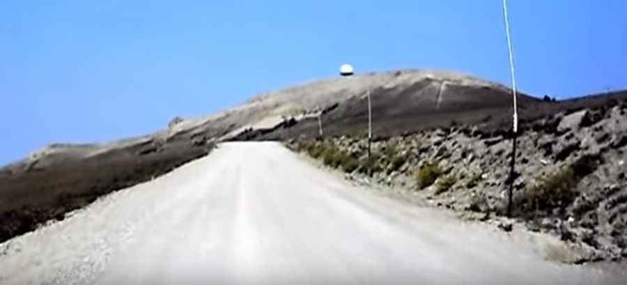
The peak is located east of Lovell, in the north-central part of Wyoming. It is easily recognized from a distance by the massive FAA radar dome on its summit. Logistically, the mountain provides a strategic vantage point over the Big Horn Basin and the Absaroka Mountain Range, making it a critical point for air traffic monitoring over Wyoming and Montana.
Why drive to Medicine Mountain?
The summit hosts the Medicine Wheel, a massive stone structure measuring 80 feet in diameter. Constructed from local white limestone, this sacred site consists of 28 alignments and attracts thousands of visitors. However, for drivers, the primary interest is the technical ascent through the Bighorn National Forest, where the roadbed sits directly upon the limestone bedrock, creating a unique high-altitude surface.
Is the road to Medicine Mountain unpaved?
Yes, the road to the summit is totally unpaved and officially designated as Forest Service Road 12. Technically, a high-clearance 4x4 vehicle is required to manage the irregular rocky surface. Driving this 4.02 km track requires steady traction management, as the limestone debris can become slippery and unstable under certain atmospheric conditions at 3,039m.
How long is the road to Medicine Mountain?
Starting from the paved U.S. Highway 14A, the drive to the summit is 4.02 km (2.5 miles) long. Over this short distance, the elevation gain is a significant 267m (879 ft), resulting in a sustained average gradient of 6.64%. This verticality puts a notable thermal load on the vehicle's engine due to the reduced oxygen density at nearly 10,000 feet.
How challenging is the road to Medicine Mountain?
Technically, the FS Road 12 is a narrow corridor where the main challenges are the altitude and the unprotected edges. While the 6.64% gradient is manageable, the thin air affects engine torque. Logistically, drivers must account for the high pedestrian traffic near the Medicine Wheel, requiring slow speeds and high situational awareness on the unpaved ramps leading to the FAA dome.
Is the road to Medicine Mountain open in winter?
No. Set high on the western edge of the northern Big Horn Range, the road is impassable from October to June. It is often closed due to heavy snow accumulation until mid-late June. Technically, the 4.02 km descent requires the use of engine braking to manage speed safely, as the unpaved surface and steep drop-offs offer no margin for braking failure or tire slip.