Driving the brutal South Colony Road to Broken Hand Peak in Colorado
Broken Hand Peak is a high mountain peak at an elevation of 3,483m (11,427ft) above sea level, located in Saguache County, in the US state of Colorado.
| Road facts: Broken Hand Peak | |
|---|---|
| Location | Saguache County, Colorado (USA) |
| Road Name | South Colony Road (FR 120) |
| Length | 12.07 km (7.5 miles) |
| Max Elevation | 3,483 m (11,427 ft) |
| Surface | Very Rocky / Unpaved |
| Vehicle Required | High-Clearance 4x4 |
Where does the road to Broken Hand Peak start?
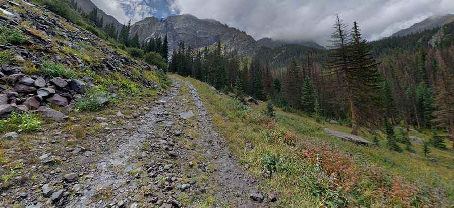
The road to the summit is called South Colony Road (Forest Road 120). It starts from Colfax Lane, located south of Westcliffe. The road runs along the South Colony Creek, climbing deep into the Sangre de Cristo range. The total length of the track from the start to the peak area is 12.07 km (7.5 miles).
Is South Colony Road open to the summit?
The final part of the road is closed to motorized vehicles. The gate is located 2.6 miles past the lower trailhead/parking lot, at an elevation of 3,017m (9,898ft) above sea level. Beyond this point, the road is only accessible to hikers, meaning you can no longer drive to the very top of the pass.
How difficult is the road to Broken Hand Peak?
The part of the road that remains open is considered "atrocious" by many drivers. It is a rocky, tippy, and bumpy trail. The surface is covered in large stones and deep ruts, making it extremely difficult to navigate in the dark or during wet, muddy conditions. Drivers should not be scared of heights, as there are narrow sections with significant drop-offs.
Is a 4x4 vehicle required for Broken Hand Peak?
A high-clearance 4x4 vehicle is required. While the first mile to the lower parking lot is manageable, anything beyond that requires specialized off-road capabilities. Standard cars or low-clearance vehicles will face severe difficulty and high risk of damage on the steep and rocky ramps.
When is the best time to drive to Broken Hand Peak?
Situated in the heart of the Sangre de Cristo Mountains, the road is impassable during the winter due to heavy snow and ice. The best time to visit is during the summer months and early fall. Even in summer, the trail is steep and can be challenging if it has rained recently, as the mud makes the rocky sections even more slippery.
Pic: Peter Khor