How to get by car to the summit of Mount Lewis in Nevada?
Mount Lewis is a high mountain peak situated in Lander County, in the U.S. state of Nevada. The summit, located in the Shoshone Range in the north-central part of the state, reaches an elevation of 2,933 meters (9,622 ft) above sea level. It is considered one of the highest roads in Nevada.
How long is the road to Mount Lewis?
The road to the summit is characterized by a challenging, sustained climb with a significant average gradient.
- Length: The road runs for 18 kilometers (11.7 miles).
- Elevation Gain: Over this distance, the road achieves an elevation gain of 1,446 meters (4,744 feet), starting from the surrounding flats.
- Average Gradient: This results in an average gradient of 7.69%, maintaining steepness throughout the entire ascent.
Is the road to Mount Lewis unpaved?
The road to Mount Lewis is totally unpaved and is generally rugged. While it is wide enough and well-graded in many sections, the sheer drop-offs can be unnerving. The surface is gravel and can be rocky and bumpy at times.
- Vehicle Requirement: A 4x4 vehicle is required for the drive.
- Safety Check: Due to the sustained gradients, drivers must ensure their brakes and tires are in good shape before attempting the route.
When is the road to Mount Lewis open?
The road is generally open year round, but heavy northern Nevada snowfall means it is best enjoyed during the spring, summer, and fall months.
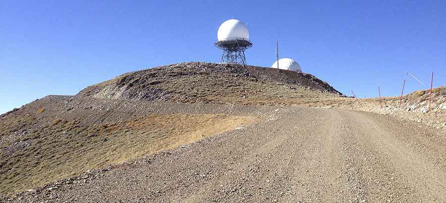
What to see at the Summit of Mount Lewis and along the way?
At the summit, visitors are rewarded with expansive 360-degree views of Battle Mountain, Crescent Valley, and the distant mountains.
- Summit Significance: An FAA Long Range Air Route Surveillance Radar station is located just west of the summit.
- Wildlife and History: The Shoshone Mountains are home to native wildlife, including desert bighorn sheep, mule deer, and raptors. Along the route, historic mining ruins, including old mill sites and relics, can be observed.
Essential Precautions for Travel to Mount Lewis
Given the rugged and remote nature of the Shoshone Range, travelers must be entirely self-sufficient:
- Tires and Tools: Carry a full-size spare tire and the tools necessary to change it.
- Navigation: Carry a paper map in addition to electronic devices.
- Supplies: Carry more food and water than you anticipate needing.
- Communication: Always let someone know where you are headed and when you plan to return.
Pic: By Famartin [CC BY-SA 4.0 (https://creativecommons.org/licenses/by-sa/4.0)], from Wikimedia Commons