Blue Nose: Driving the technical Forest Service Road 310
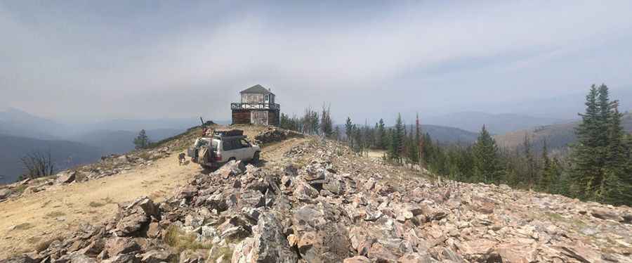
Blue Nose is a high-altitude mountain summit reaching 2,641m (8,664ft) above sea level on the border between Montana and Idaho. Located within the Salmon National Forest, the road to the summit is the Forest Service Road 310. This is a technical unpaved track that leads to a historic fire lookout tower built in 1934. It is a demanding drive where the combination of loose rock, narrow sections, and the lack of maintenance on the high-altitude roadbed requires a high-clearance 4x4 and advanced skills in mountain transit.
| Road facts: Blue Nose | |
|---|---|
| Location | Montana-Idaho border (Salmon National Forest) |
| Max Elevation | 2,641m (8,664ft) |
| Length | 1.2 miles (1.93 km) |
| Average Gradient | 7.77% |
How challenging is the 1.2-mile climb on Forest Service Road 310 to Blue Nose?
The journey to the summit begins at the junction with the NF-044 road and covers 1.2 miles of intense mountain terrain. Over this short distance, the road gains 492 feet in elevation, resulting in an average gradient of 7.77%. The ferro of this route is the surface stability; the FR 310 is notoriously rocky, bumpy, and "tippy" in several sections where the track narrows significantly. Driving this stretch requires a vehicle with a high-clearance undercarriage to avoid damage from the large stones and ruts that characterize the ascent. If you are not used to handling a 4x4 on steep, unpaved ledges, the vertical exposure on the final approach to the 2,641m mark will be a major psychological hurdle.
Why is the Blue Nose fire lookout area dangerous for vehicles?
Reaching the summit of Blue Nose puts you in a high-consequence environment where the infrastructure is in a state of decay. The fire lookout tower, while open to the public, is unreliable and surrounded by debris like broken glass and loose door frames. For a driver, the main risk at the summit is the lack of a proper turning circle; the ground is often spongy and the wooden deck boards of the tower are rotten, making it difficult to find a stable spot to park or turn the vehicle around. The high winds that frequent the peak can also make handling a high-profile vehicle unpredictable on the narrowest parts of the ridge.
What are the risks of driving the Salmon National Forest high-altitude tracks?
The road to Blue Nose is subject to the volatile weather of the Montana-Idaho border. During wet periods, the clay-heavy soil of the Salmon National Forest turns into a thick, slippery mud that fills the ruts of the FR 310. In these conditions, maintaining a driving line becomes a high-stakes task as the tires lose lateral grip on the unpaved surface. The average gradient of 7.77% can feel much steeper when you are fighting for traction on a muddy roadbed. Self-sufficiency is the rule here; you must carry recovery gear and a full-sized spare tire, as a breakdown at 2,641 meters in such a remote area means waiting for help that is miles away from any paved highway.
How does the mountain weather affect the road to Blue Nose?
At an elevation of 8,664ft, Blue Nose is buried under heavy snow for most of the year, making the road impassable from late autumn through early summer. Even in the height of the driving season, sudden storms can drop temperatures to freezing levels and wash debris onto the track. The harsh elements have already claimed much of the summit infrastructure, and the same forces work to erode the road surface, creating deep washouts that can trap a vehicle without the necessary suspension travel. Before starting the 1.2-mile climb from NF-044, checking the mechanical state of your brakes and tires is vital, as the descent back down the technical gravel ramps requires perfect control to avoid sliding toward the unprotected edges of the mountain.
Pic: Wes Craiglow