How to get by car to Verdi Peak in the Sierra Nevada Mountains?
Verdi Peak is a high mountain peak at an elevation of 2,562m (8,405ft) above sea level, located in Sierra County, in the US state of California. Make sure you have high clearance.
Where is Verdi Peak?
The peak is located west of Reno, in the northeastern part of California, near the Nevada border.
What’s at the summit of Verdi Peak?
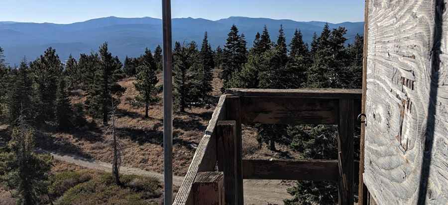
At the summit, there’s a fire lookout, now abandoned. Built in the early 1930s, the original structure was replaced by the current cabin in 1983. It provides awesome views of the Reno Valley and the surrounding landscape north of Truckee.
How challenging is the road to Verdi Peak?
The fire road to the summit is totally unpaved. It’s called Verdi Peak Road. 4WD required. The road is very rocky, with medium-sized, round stones about the size of a doll’s head. These rocks can make the road rough and hard to drive on, especially if you're not in a 4x4 or a vehicle with high clearance. It’s the kind of surface that can be slippery or bumpy, and you might need to drive slowly to avoid damaging your car. It’s a narrow and increasingly difficult dirt road in the last few miles to the peak.
How long is the road to Verdi Peak?
The road is steep, hitting a maximum gradient of 11.7% through some of the ramps. Starting at County Road S860, the ascent is 10.78km (6.7 miles) long. Over this distance, the elevation gain is 569 meters. The average gradient is 5.27%.
Is the road to Verdi Peak open in winter?
Set high in the Verdi Range of the northern Sierra Nevada Mountains, the road can remain covered in snow and mud late into the season due to its steep, shady setting. It is typically snow-covered from late November through late April or mid-May.
Pic: Marc Belanger