How to get to the lookout at Sardine Peak in California?
Sardine Peak is a high mountain peak at an elevation of 2,482m (8,143ft) above sea level, located in Sierra County, in the U.S. state of California.
Where is Sardine Peak?
The peak is located approximately 20 miles north from Truckee, in the northeastern part of California, within the Tahoe National Forest.
Why is it called Sardine Peak?
The peak was named after Sardine Canyon, which sits below and west.
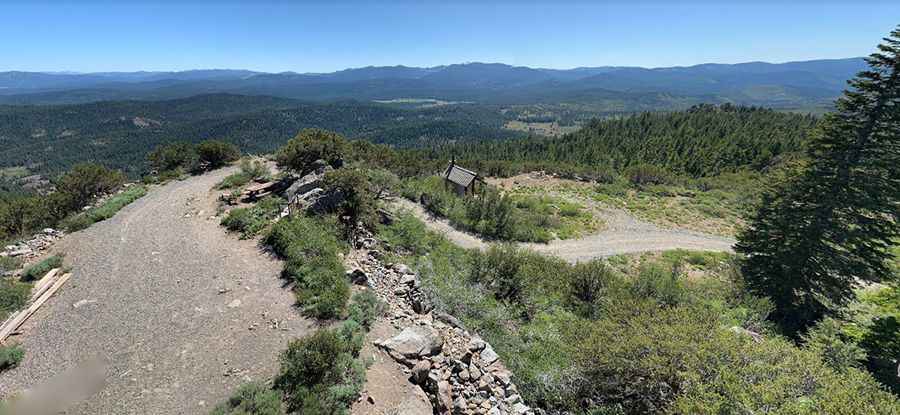
What’s at the summit of Sardine Peak?
Tucked away on the eastern slopes of the Northern Wasatch Mountains, at the summit there’s a forest fire lookout tower that was constructed in 1935 by the Civilian Conservation Corps. It is a three-story enclosed tower with external stairs. The summit offers spectacular views of Stampede Reservoir, Boca Reservoir, Sardine Valley, Independence Lake, the top of the Sierra Buttes and western Nevada.
Is the road to Sardine Peak unpaved?
The unimproved Forest Service Road to the summit is totally unpaved. It’s a wide and rutted four-wheel drive road. It’s a bit rough at places. You do not need a 4WD, high-clearance vehicle, although it’s preferential. Passenger cars are not recommended.
How long is the road to Sardine Peak?
Starting at the paved CA-89, the road to the summit is 16.41km (10.2 miles) long.
Is the road to Sardine Peak open in winter?
Set high in the Eastern Sierra Nevada Mountains, the road to the summit is usually impassable in winters, from November through May.
Pic: doug smith