How to get by car to the lookout at Thompson Peak in California?
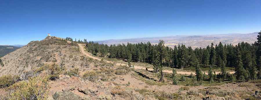
Thompson Peak is a high mountain peak at an elevation of 2,366m (7,762ft) above sea level, located in the northeastern part of California, USA. Situated within the Plumas National Forest, the summit offers an extensive view of the surrounding Sierra Nevada range and the high desert of the Great Basin.
| Road facts: Thompson Peak | |
|---|---|
| Elevation | 2,366m (7,762ft) |
| Coordinates | 40.2319, -120.5705 |
| Road Name | NFS Road 28N02A |
| Surface | Unpaved / Rough |
| Average Gradient | 6.96% |
| Length | 15.9 km (9.9 miles) |
Where is Thompson Peak located?
The peak is located south of Johnstonville, on the boundary between Lassen and Plumas counties. It sits near the Nevada border in the Diamond Mountains subrange. The area is remote and managed by the Plumas National Forest, characterized by rugged terrain and dense timber at lower elevations.
What is the history of the Thompson Peak fire lookout?
The summit has a rich history of strategic and defensive use:
- Fire Lookout: Built between 1931 and 1932, the lookout was used during World War II as an observation post for enemy aircraft spotting. It remains seasonally staffed today for fire detection.
- Gap-Filler Radar: Below the lookout stands an abandoned building from the Cold War era (1960–1967). This was a Gap-Filler Radar station designed to detect low-flying aircraft that were invisible to long-range radar networks.
- Etymology: The mountain was named after Manly Thompson, an early pioneer who constructed one of the first cabins in the region in 1875 near the base of the mountain.
Is the road to Thompson Peak unpaved?
The route to the summit is strictly an off-road challenge. It follows the National Forest System (NFS) Road 28N02A. The track is entirely unpaved, narrow in several sections, and features steep sustained gradients.
- Vehicle Requirements: A high-clearance vehicle is the minimum requirement; however, a 4x4 or off-road vehicle is strongly recommended due to the loose surface and potential for deep ruts.
- Technical Specs: Starting from the paved US Highway 395 near Janesville, the road climbs 1,107m over a distance of 15.9 km, with an average gradient of 6.96%.
Is the road to Thompson Peak open in winter?
Set high in the Diamond Mountains, a subrange of the Sierra Nevada, the road is impassable during winter months due to heavy snow accumulation. The access typically opens in late spring or early summer. Drivers should be prepared for sudden weather changes and carry essential supplies, as there are no services available on the mountain.
Pic: Sierra Falkowski