How to drive the unpaved road to Buena Vista Peak in Colorado?
Buena Vista Peak is a high mountain peak at an elevation of 2,614m (8,575ft) above sea level located in Moffat County, in the US state Colorado.
| Road facts: Buena Vista Peak | |
|---|---|
| Location | Moffat County, Colorado (USA) |
| Elevation | 2,614 m (8,575 ft) |
| Length | 9.6 km (5.96 miles) |
| Surface | Unpaved / Bentonite Clay |
Where is Buena Vista Peak?
The peak is located south of Zenobia Peak, in the northwestern part of Colorado, near the Utah border, within the Dinosaur National Monument.
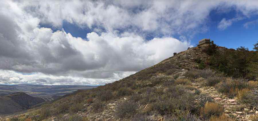
Why is there a road to Buena Vista Peak?
At the summit there’s a fire lookout tower (built in 1964). It provides views of Redwood Canyon, Sierra Crest summits, and Kings Canyon high country.
How long is the road to Buena Vista Peak?
Starting from the paved Harpers Corner Road, the road to the summit is 9.6 km (5.96 miles) long. A 4x4 vehicle with low-range is required.
Is the road to Buena Vista Peak unpaved?
Running through the Douglas Mountain plateau across conifer forest and wildflowers, the road is totally unpaved with loose gravel and deep rut. It is a classic shelf road with vertical drops and no guardrails. The track is narrow, often limited to the width of a single truck, meaning you might have to reverse along a cliff edge if you meet oncoming traffic. The road surface contains high concentrations of bentonite clay, known as "gumbo."
Is the road to Buena Vista Peak open year-round?
The road is usually impassable in winters. Check the weather forecast before leaving Harpers Corner Road. If it starts to rain while you are at the top, descend immediately before the road turns into an ice rink of clay.
Pic: J H