Discovering the Beauty of Old Fall River Road: A Journey Through Colorado's Wilderness
Old Fall River Road is the name of a narrow one-lane dirt road with perilous heights located in Larimer County, in the U.S. state of Colorado. It’s one of the highest roads in Colorado.
How long is the Old Fall River Road?
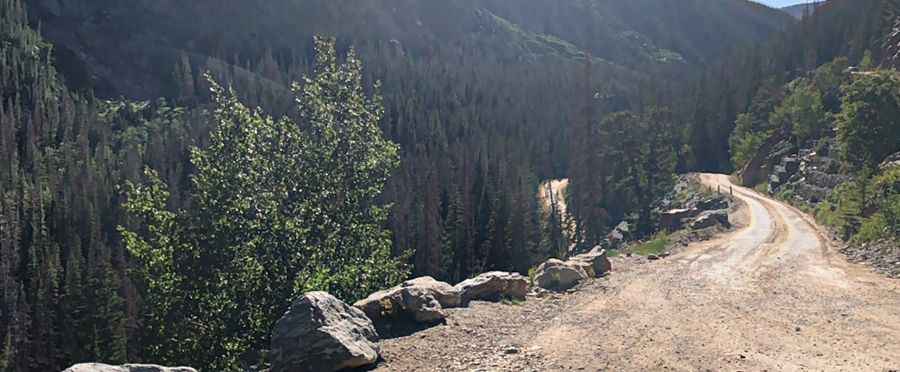
The road is 17.21 km (10.7 miles) long, running east-west from Fall River Road to Fall River Pass on the Trail Ridge Road. It’s totally unpaved but navigable by all passenger vehicles. You do not need a four-wheel-drive vehicle in dry weather.
Is the Old Fall River Road open?
Set high in Rocky Mountain National Park, a national park in the north-central region of the U.S. state of Colorado, Old Fall River Road climbs almost to the same height as Trail Ridge but does so via an unpaved road. The road ends at 3,602 m (11,817 ft) above sea level. Typically, the road is open by the Fourth of July weekend and closes for the season in October.
How long does Old Fall River Road take to drive?
The old scenic road quietly leads travelers through the park's wilderness. It takes approximately 40 minutes to drive, but plan for a 2-hour round trip. The journey to the alpine world at the top of the drive is relaxing. The experience is one to be savored. It’s an ideal drive for visitors seeking to become intimate with nature. In places, the trees of the montane and subalpine forests are so close that motorists can touch them.
How scary is Old Fall River Road?
It is an unforgettable drive with perilous heights. There are no guardrails along this road. This road can be driven in any normal passenger vehicle when dry (RVs are prohibited). Primarily gravel, it’s a one-way uphill road with many switchbacks. The posted speed limit is 15 miles per hour, a clear indication that a journey up the road is not for the impatient. It’s a good thing because there are no guardrails, and the road is narrow and curved. Yet the road is safe, and there are many pull-offs. In places, the trees of the montane and subalpine forests are so close that motorists can touch them. If you don't like driving up the mountain on a dirt road with hairpin turns, better avoid it. The road width rarely exceeds 14', too narrow for cars to pass safely. Passing turnouts were provided, but these were few and far between. Before you take this drive, stop by one of the Rocky Visitors Centers and pick up a copy of the $1 guide called "Old Fall River Road". When you do take the ride, stop frequently and often, as every "pull-off" or parking area has much to offer.
When was Old Fall River Road built?
The trail was opened in 1920 and earned the distinction of being the first auto route in Rocky Mountain National Park offering access to the park's high country. Starting by Larimer and Grant counties in 1913 before the establishment of Rocky Mountain National Park, the early construction was carried out by state prison inmates. The convicts made little progress, and contractors completed the road in 1920. In 1968, the National Park Service restored the road, paving the lower third. The road climbed to Fall River Pass on steep grades, sometimes reaching 16%. Some early automobiles had to climb in reverse due to their weak engines and gravity-fed fuel system. Surface materials washed off quickly. Motorists had to negotiate sixteen switchbacks with radii as tight as 20'. Some vehicles had to turn back and forth repeatedly to make the curves. The road follows a route traveled long ago by Indian hunters. The roadway was largely built out from the hillside. In the steepest places, multiple switchbacks were stacked one above the other. Few pullouts were provided to allow motorists to stop; some were located on switchbacks, making the curves even more difficult.
Pic: Ashish Sharma