A memorable road trip to Smith Mountain in Adams County
Smith Mountain is a high mountain peak at an elevation of 2,442 m (8,011 ft) above sea level located in Adams County, in the US state of Idaho.
Where is Smith Mountain?
The peak is located in the western part of Idaho, near the Oregon border, within the Payette National Forest. Don't go there during a thunderstorm – lightning. Cell phone service is generally not accessible on this route.
What’s at the summit of Smith Mountain?
The summit hosts a lookout called Smith Mountain Lookout. Established with a camp in 1908, a cupola cabin was built in 1920. This was replaced by an L-4 cab in 1932. The present 10' concrete base with a 16x16' cab, built in 1963, is available for emergencies.
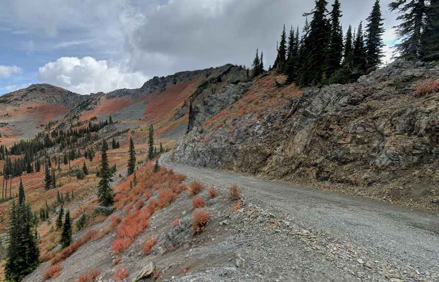
Is the road to Smith Mountain unpaved?
The road to the summit is totally unpaved. It’s called Black Lake Road. The route is extremely picturesque, offering broad panoramic views of the Cabinet and Purcell Mountains.
How challenging is the road to Smith Mountain?
It’s a steep and rough road with some rocks in it. It’s not recommended for RVs, trailers, or low clearance vehicles. Not suitable for passenger cars, a vehicle with high clearance is required. The road has a “no trailers” sign posted at the 5.1-mile mark, and attempting to continue with one beyond that point would be extremely difficult due to limited space for turning around. In spring, runoff often brings water onto or alongside the roadway. The route is not heavily traveled, there are no Forest Service vault toilets, and fallen trees may sometimes need to be cleared from the path. Some maintenance was completed in 2023, leaving the trail in fairly good condition, with little to no vegetation encroaching. However, both trail and weather conditions can shift quickly, so preparation is essential. The final two miles are the most demanding, becoming steeper, rougher, and occasionally off-camber, with sections of ruts adding to the challenge.
How long is the road to Smith Mountain?
The road to the summit is steep. Starting at NF-105 (gravel road suitable for passenger cars), the ascent is 10 km (6.21 miles) long. Over this distance, the elevation gain is 698 meters. The average gradient is 6.98%.
Pic: Jackson Davis